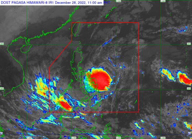
Davao Provinces brace for heavy rains, flooding as LPA looms

https://www.facebook.com/PAGASA.DOST.GOV.PH/posts/pfbid0CV35s38Xw5uyMmpaTLWqZBNQ2K1MPezPMorxyhZxg7A4moYatfU65Ju6RVQTxVbZl
MANILA, Philippines — The Davao provinces risk flooding on Wednesday as a low-pressure area (LPA) moves closer to the country’s landmass, the state weather agency warned.
According to the latest weather advisory from the Philippine Atmospheric, Geophysical and Astronomical Services Administration (Pagasa), the LPA was spotted some 260 kilometers east-northeast of Hinatuan, Surigao del Sur.
The forecast doesn’t rule out its strengthening into a tropical depression, which could devastate parts of Mindanao.
“The LPA will bring moderate to heavy with at times intense rains over Eastern Visayas. Moderate to at times heavy rains are expected over Caraga, Northern Mindanao, Davao region, Zamboanga Peninsula, the rest of Visayas, Bicol region and Palawan,” Pagasa said in its mid-day advisory.
Pagasa also warned of possible flooding and rain-induced landslides.
Article continues after this advertisementDavao flood alert
State meteorologists have also released a flood advisory for areas near and around rivers and tributaries in Davao Oriental, Davao De Oro, Davao Del Norte, Davao Del Sur and Davao Occidental.
Those living on these areas’ mountain slopes and riversides are advised to take precautionary measures.
“The public and disaster risk reduction and management offices concerned are advised to take all necessary measures to protect life and property,” Pagasa added.
Rough seas
Due to strong winds caused by the northeast monsoon winds, Pagasa has also released a new set of gale warnings as of 11:00 a.m.
Fishermen and crewmen of small vessels in affected areas listed below are advised against setting sail due to rough sea conditions.
- Batanes
- Cagayan including Babuyan Islands
- Isabela
- Aurora
- Ilocos Norte
- Ilocos Sur
- La Union
- Pangasinan
- Zambales
- Quezon (General Nakar, Mauban, Sariaya, Lucena City, Pagbilao, Atimonan, Padre Burgos, Agdangan, Unisan, Pitogo, Macalelon, General Luna, Catanauan, Mulanay, San Francisco, San Andres, Buenavista, San Narciso, Guinayangan, Tagkawayan, Gumaca, Plaridel, Lopez, Calauag, Quezon, Alabat, And Perez) including the Northern and eastern coasts Of Polillo Islands (the northern Coast Of Panukulan, Burdeos, The Eastern Coast Of Polillo, Patnanungan, And Jomalig)
- Romblon
- Marinduque
- Camarines Norte
- Northern and eastern coasts of Camarines Sur
- Catanduanes
- Eastern coast of Albay
- Eastern and southern coasts of Sorsogon
- Batangas
- Oriental Mindoro
- Occidental Mindoro including Lubang Island
- Cuyo Islands
- Northern Samar
- Eastern Samar
- Southern Leyte
- Antique
- Aklan
- Dinagat Islands
- Surigao Del Norte including Siargao
- Bucas Grande Islands
RELATED STORIES:
Pagasa: Wet Wednesday in parts of PH as LPA looms
LPA hovers east of Mindanao; becoming a cyclone a possibility says Pagasa
gsg/abc