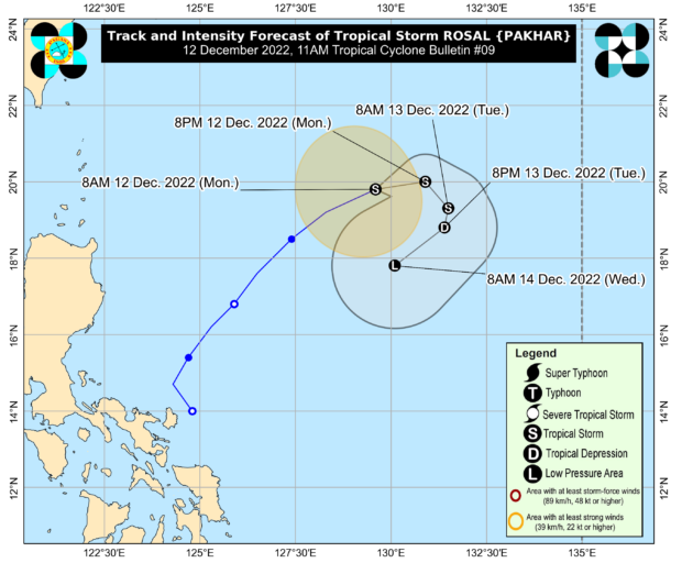
Track of Tropical Storm Rosal (international name: Pakhar). Photo from Pagasa’s website
MANILA, Philippines — Tropical Storm Rosal (international name: Pakhar) is maintaining its strength as it accelerates east-northeastward of the country, the Philippine Atmospheric, Geophysical, and Astronomical Services Administration (Pagasa) said in its 11 a.m. weather bulletin.
“Rosal is less likely to directly bring heavy rains in the country throughout the forecast period,” the state weather bureau, however, said.
Pagasa also said that no Tropical Cyclone Wind Signal was raised in any part of the country due to Rosal. But it noted that the combined effects of the surge of the northeast monsoon (locally termed amihan) and the tropical storm might bring occasional gusts reaching gale force over Batanes and a strong breeze to near-gale strength over Babuyan Islands, the coastal and upland areas of Ilocos Norte, northern and eastern Cagayan, and eastern Isabela.
A marine gale warning, it added, remains in effect over the seaboards of Northern Luzon.
Weather satellite image. Photo from Pagasa’s website
Based on the state weather service’s latest monitoring, Rosal’s center was located 860 kilometers east of extreme northern Luzon. The tropical storm was moving 25 kilometers per hour (kph) with maximum sustained winds of 85 kph and gustiness of up to 105 kph.
Rosal is expected to move east-northeastward within the next six hours before generally moving eastward for the remainder of Monday. Pagasa said Rosal is seen to weaken by Monday evening.
“Rosal is forecast to become a remnant low [pressure area] tomorrow late evening or on Wednesday early morning before dissipating shortly thereafter,” it reported in its 11 a.m. weather bulletin.
RELATED STORY:
Tropical storm Rosal intensifies while moving away from PH