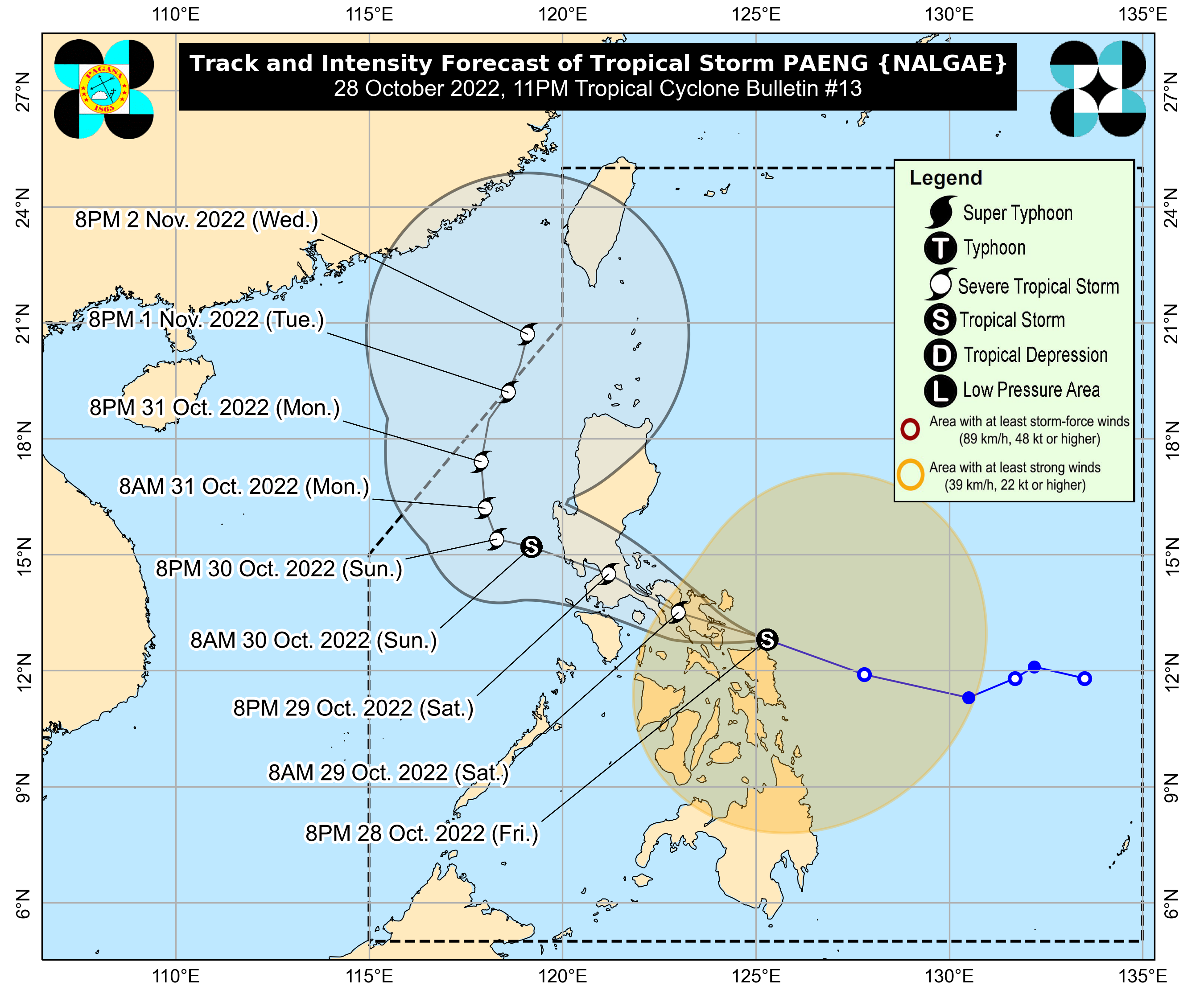
MANILA, Philippines — Tropical Storm Paeng was able to maintain strength as it moves closer to the waters near Albay and Camarines Sur provinces, reports from the Philippine Atmospheric, Geophysical and Astronomical Services Administration (Pagasa) on Friday night showed.
Pagasa in its latest update said it expects Paeng to make landfall in either Albay, Camarines Sur, or Catanduanes anytime between late Friday night or early Saturday morning.
Paeng still packs maximum sustained winds of 85 kilometers per hour (kph) near the center and gustiness of up to 105 kph.
Its center was last seen over the coastal waters of Ragay, Albay, and it is currently moving west-northwest at a speed of 25 kph.
As of posting, state meteorologists expect Paeng to intensify into a severe tropical storm as it crosses the Bicol Region, but it is also not ruling out that the cyclone would remain a tropical storm by the time it hits Metro Manila.
The latest forecast track still puts Paeng on track to hit Metro Manila by Saturday night, before emerging over Manila Bay en route to the western provinces of Central Luzon. Paeng would then turn north, and may be out of the Philippine area of responsibility by Tuesday night or Wednesday morning.
As of now, the following areas are under Tropical Cyclone Wind Signal No. 2:
Luzon
- Bicol Region: Catanduanes, Albay, Sorsogon, Masbate including Ticao and Burias Islands, Camarines Sur, Camarines Norte
- Calabarzon: Quezon including Pollilo Islands, Laguna, Batangas, Cavite, Rizal
- Metro Manila
- Mimaropa: Marinduque, the northern and central portions of Oriental Mindoro (Puerto Galera, San Teodoro, Baco, City of Calapan, Naujan, Victoria, Pola, Socorro, Pinamalayan, Gloria, Bansud, Bongabong, Roxas), the northern and central portions of Occidental Mindoro (Sablayan, Santa Cruz, Mamburao, Abra de Ilog, Paluan) including Lubang Islands, and Romblon
- Central Luzon: Bulacan, the southern portion of Aurora (San Luis, Baler, Dingalan, Maria Aurora), the central and southern portions of Nueva Ecija (City of Gapan, San Leonardo, Santo Domingo, Rizal, San Isidro, Laur, Zaragoza, Llanera, Aliaga, Palayan City, Gabaldon, General Mamerto Natividad, Cabanatuan City, Quezon, San Antonio, General Tinio, Santa Rosa, Pe, Jaen, Licab, Bongabon, Cabiao, Talavera), the central and southern portions of Tarlac (La Paz, City of Tarlac, San Jose, Gerona, Mayantoc, Pura, Bamban, Capas, Santa Ignacia, Victoria, Concepcion), Pampanga, Bataan, the central and southern portions of Zambales (Masinloc, Palauig, Iba, Botolan, Cabangan, San Marcelino, Subic, Olongapo City, Castillejos, San Antonio, San Narciso, San Felipe)
Visayas
- Northern Samar, Eastern Samar, Samar
- Biliran and the northern portion of Leyte (San Isidro, Calubian, Tabango, Leyte, Capoocan, Carigara, Barugo, San Miguel, Babatngon, Tacloban City, Alangalang, Santa Fe, Palo, Tanauan, Dagami, Pastrana, Jaro, Kananga, Villaba, Tunga, Tabontabon, Tolosa)
The following areas are under Tropical Cyclone Wind Signal No. 1:
Luzon
- Cagayan Valley: The central and southern portions of Isabela (San Agustin, Jones, City of Santiago, Cordon, Echague, Dinapigue, San Mariano, San Guillermo, Angadanan, City of Cauayan, Benito Soliven, Ramon, San Isidro, Alicia, San Mateo, Cabatuan, Luna, Reina Mercedes, Naguilian, Palanan, Aurora, Burgos, San Manuel, Gamu, Ilagan City, Divilacan, Roxas, Quirino, Mallig), Nueva Vizcaya, Quirino
- Cordillera: Benguet, Ifugao, Mountain Province
- Ilocos Region: the southern portion of Ilocos Sur (Sugpon, Cervantes, Alilem, Suyo, Tagudin, Santa Cruz, Sigay, Quirino, Gregorio del Pilar, Salcedo, Santa Lucia), La Union, Pangasinan
- Central Luzon: the rest of Aurora, the rest of Nueva Ecija, the rest of Zambales, the rest of Tarlac
- Southern Luzon: the rest of Oriental Mindoro, the rest of Occidental Mindoro, and the northern portion of Palawan (El Nido, Taytay) including Calamian and Cuyo Islands
Visayas
- Western Visayas: Southern Leyte, rest of Leyte
- Central Visayas: Cebu including Bantayan and Camotes Islands, Bohol, Negros Occidental, Siquijor
- Eastern Visayas: Negros Oriental, Guimaras, Aklan, Antique, Capiz, Iloilo
Mindanao
- Dinagat Islands
- Surigao del Norte including Siargao and Bucas Grande Islands, the northern portion of Surigao del Sur (Carrascal, Cantilan, Madrid, Carmen, Lanuza, Cortes, City of Tandag, Bayabas, Cagwait, San Miguel, Tago, Marihatag, San Agustin, Lianga, Barobo)
- Agusan del Norte, the northeastern portion of Agusan del Sur (Sibagat, Esperanza, City of Bayugan, Prosperidad)
- Camiguin
- Misamis Oriental
READ: Over 33,000 Bicol residents evacuate due to Paeng