
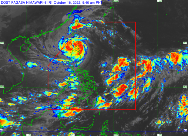
MANILA, Philippines — Tropical Cyclone Wind Signal No. 3 is up over two areas in northern Luzon as Severe Tropical Storm Neneng (international name: Nesat) maintained its strength and made landfall in Cagayan Sunday morning, according to the Philippine Atmospheric Geophysical and Astronomical Services Administration (Pagasa).
Pagasa weather specialist Benison Estraja said Neneng made landfall in Calayan, Cagayan at 3:50 a.m. on Sunday
Neneng is packing a maximum wind speed of 95 kilometers per hour (kph) near the center and gustiness of up to 130 kph.
“Lalabas ito ng Philippine area of responsibility (PAR) base sa ating latest track either mamayang gabi o bukas ng madaling araw,” said Estareja.
(Neneng will exit PAR based on Pagasa’s latest track either tonight or tomorrow morning.)
Rainfall alert
Heavy to intense and at times torrential rains are expected Apayao, Ilocos Norte, and northern Cagayan including Babuyan Islands from Sunday morning until noon, while moderate to heavy and at times intense rains are forecast in Abra, Kalinga, northern part of Ilocos Sur, and the rest of Cagayan.
Light to moderate and at times heavy rains, meanwhile, are expected in Batanes, Mountain Province, rest of Ilocos Sur, and northern Isabela, while moderate to heavy rains will prevail in Ilocos Norte.
Rough seas warning
The state weather bureau also raised a gale warning over the seaboards of Batanes, Cagayan, Isabela, Ilocos Norte, Ilocos Sur, La Union and Pangasinan where large waves from 2.8 meters to 5.5 meters are possible.
Signal No. 3 (storm-force winds prevailing or expected in at least 18 hours) is up over the following areas:
- The southern portion of Batanes (Basco, Mahatao, Uyugan, Ivana, Sabtang) and Babuyan Islands
Signal No. 2 (gale-force winds prevailing or expected within the next 24 hours) is up over the following areas:
- the rest of Batanes
- the rest of Cagayan
- Apayao
- the northern portion of Abra (Tineg, Lacub, Lagayan)
- Ilocos Norte
Signal No. 1 (strong winds prevailing or expected within the next 36 hours) was raised over the following areas:
- the northern and central portions of Isabela (Santa Maria, San Pablo, Maconacon, Divilacan, Palanan, Ilagan City, Tumauini, Cabagan, Santo Tomas, Quezon, Delfin Albano, Mallig, Quirino, Gamu, Roxas, San Mariano, Benito Soliven, Naguilian, Burgos, Reina Mercedes, San Manuel, Aurora, Luna, Cabatuan, San Mateo, Dinapigue, City of Cauayan)
- Kalinga
- the rest of Abra
- Mountain Province
- the northern portion of Ifugao (Aguinaldo, Alfonso Lista, Mayoyao, Hungduan, Banaue),
- the northern and central portions of Ilocos Sur (Sinait, Cabugao, San Juan, Magsingal, Santo Domingo, San Ildefonso, San Vicente, Santa Catalina, Bantay, City of Vigan, Santa, Caoayan, Narvacan, Nagbukel, Santa Maria, San Esteban, Santiago, Burgos, Banayoyo, Lidlidda, San Emilio, Quirino, Gregorio del Pilar, Galimuyod, City of Candon, Santa Lucia, Salcedo, Cervantes, Suyo, Sigay, Santa Cruz)
gsg