
MANILA, Philippines —Tropical cyclone wind signal (TCWS) number 1 remains in effect as of Saturday morning in five areas as tropical depression Neneng swirls toward northern Luzon, according to the Philippine Atmospheric, Geophysical and Astronomical Services Administration (Pagasa).
TCWS number 1 is still up over Batanes, Cagayan, northern and eastern part of Apayao (Lunao, Santa Marcela, Flora, Pudtol, Calansanan), extreme northern part of Isabela (Santa Maria, San Pablo, Maconacon) and northern part of Ilocos Norte (Pagudpud, Bangui, Burgos, Pasuquin, Vintar, Dumalneg, Adams)
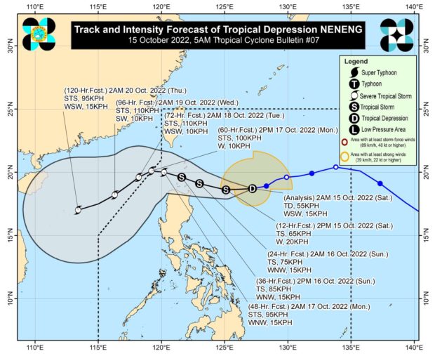
In its early morning update, Pagasa said Neneng was spotted some 576 kilometers east of Calayan, Cagayan, with maximum sustained winds of 55 kilometers per hour (kph) near the center and gustiness of up to 70 kph.
“At sa mga susunod na oras, asahan pa natin na mas maraming lugar pa dito sa northern Luzon ang magkakaroon pa ng ulan at mga pagbugso ng hangin,” said Pagasa weather forecaster Benison Estreja.
(In the coming hours, rain and windy conditions are expected in more areas in northern Luzon.)
Storm alert; rough seas up North
Estreja added that Neneng is likely to further intensify into a tropical storm as early as Saturday afternoon, and that TCWS No. 2 may be raised in areas currently under TCWS No. 1
Pagasa also warned of possible flash floods and landslides as we as rough sea conditions off Batanes, Cagayan, Isabela, Ilocos Norte and Ilocos Sur.
Cloudy weekend with rain showers
Rain showers and thunderstorms due to Neneng’s trough or extension are likewise expected in the Bicol region, Mimaropa (Mindoro, Marinduque, Romblon, Palawan), and Western Visayas.
Meanwhile, Metro Manila and the rest of the country can expect partly cloudy to cloudy skies with isolated rain showers due to localized thunderstorms or Neneng’s trough.