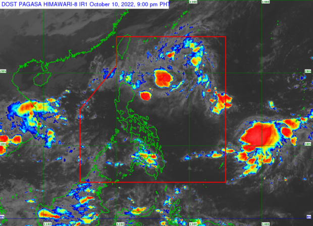

MANILA, Philippines — Tuesday will bring cloudy skies and heavy rain due to a low-pressure area (LPA) and shear line in northern Luzon, according to the state weather bureau, which also warned of increased chances of flooding and landslides in these areas.
According to Philippine Atmospheric, Geophysical and Astronomical Services Administration (Pagasa) weather specialist Grace Castañeda, the said LPA was last spotted 405 kilometers east of Casiguran, Aurora.
“Ito ay may posibilidad na magdevelop at maging tropical depression within 48 hours habang ito ay kumikilos pakanluran patungo sa ilang bahagi ng Northern Luzon kung saan magdudulot ng pagulan bukas at sa mga susunod na araw,” she said.
(It has the possibility of developing into a tropical depression within 48 hours as it moves westward toward some parts of northern Luzon where it will bring rain tomorrow and the following days.)
She added that the shear line is also affecting parts of extreme northern Luzon, which will also bring rain over these areas.
“Para lagay ng panahon bukas, maulan na kalaangitan at pagulan na mararanasanan sa bahagi ng Batanes, Cagayan, Isabela and also sa bahagi ng Ilocos Norte, Apayao, Abra Kalinga at Mountain Province,” said Castañeda.
(For tomorrow’s weather, rainy skies will be experienced in parts of Batanes, Cagayan, Isabela and also in parts of Ilocos Norte, Apayao, Abra Kalinga and Mountain Province.)
“Maging alerto at magingat dahil magiging mataas ang pagbanta ng pagbaha at pagguho ng lupa dahil makakaranas po tayo ng malalakas na pagulan na dulot ng LPA at shearline,” she added.
(Be alert and be careful because the threat of flooding and landslides will be high because we will experience heavy rains caused by the LPA and shearline.)
Meanwhile, the rest of Luzon, including Metro Manila, will have generally fair weather with chances of rain.
On the other hand, slightly cloudy to overcast skies are forecast over Visayas and Mindanao along with chances of rain due to isolated thunderstorms.
Another LPA is also currently being monitored by Pagasa outside PAR, which Castañeda said is currently located 1,770 kilometers east of Visayas.
It is expected to enter the Philippine area of responsibility within the next three days and has so far no direct effects on the country.
Currently, a gale warning is raised over the northern seaboards of northern Luzon, including Batanes, Cagayan, Ilocos Norte, and Ilocos Sur. This means small vessels and fishing boats are not allowed to sail in these areas.
The state weather service said the temperature range in key cities/areas across the country for Tuesday would be:
- Metro Manila: 24 to 33 degrees Celsius
- Baguio City: 15 to 23 degrees Celsius
- Laoag City: 23 to 29 degrees Celsius
- Tuguegarao: 23 to 30 degrees Celsius
- Legazpi City: 25 to 32 degrees Celsius
- Puerto Princesa City: 26 to 33 degrees Celsius
- Tagaytay: 22 to 31 degrees Celsius
- Kalayaan Islands: 26 to 33 degrees Celsius
- Iloilo City: 26 to 32 degrees Celsius
- Cebu: 25 to 32 degrees Celsius
- Tacloban City: 25 to 33 degrees Celsius
- Cagayan De Oro City: 24 to 31 degrees Celsius
- Zamboanga City: 24 to 33 degrees Celsius
- Davao City: 26 to 33 degrees Celsius
RELATED STORY:
Pagasa forecast: 2 to 4 tropical cyclones in October