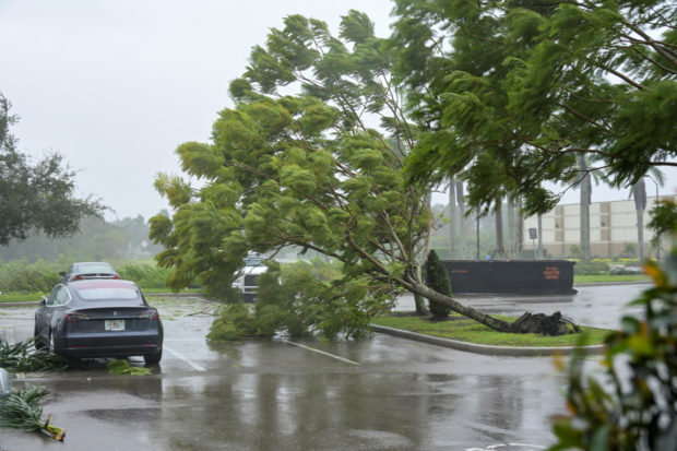
Hurricane Ian crashes ashore in Florida with Category 4 fury

Gusts from Hurricane Ian begin to knock down small trees and palm fronds in a hotel parking lot in Sarasota, Florida, U.S. September 28, 2022. (REUTERS)
VENICE, Fla. – Hurricane Ian plowed into Florida’s Gulf Coast with catastrophic force on Wednesday, unleashing howling winds, torrential rains and a treacherous surge of ocean surf that made it one of the most powerful U.S. storms in recent years.
Ian made landfall at 3:05 p.m. EDT (1905 GMT) near Cayo Costa, a barrier island just west of Fort Myers, as a Category 4 hurricane, with sustained winds of up to 150 miles per hour (241 km per hour), the U.S. National Hurricane Center (NHC) reported.
The storm’s wind speeds put it just shy of a Category 5 designation on the Saffir-Simpson scale, the most severe classification for storms with maximum sustained winds of at least 157 mph.
About 90 minutes later, the NHC reported Ian had moved ashore the Florida mainland just south of the harborside town of Punta Gorda, with slightly diminished sustained winds topping out at 145 mph.
Governor Ron DeSantis said Ian had generated life-threatening storm surges – waves of wind-driven seawater flooding along the coast – of up to 12 feet (3.7 meters) in some places. Forecasters also warned of intense thunderstorms and possible tornadoes, with up to 2 feet of rain expected in parts of central Florida as the storm moved further inland.
Article continues after this advertisement“This is a storm that we will talk about for many years to come, an historic event,” said Ken Graham, director of the National Weather Service.
Article continues after this advertisementThe region around the landfall is home to miles of sandy beaches, scores of resort hotels and numerous mobile home parks, a favorite with retirees and vacationers alike. But the storm soon transformed idyllic coastal towns into disaster zones.
SCENES OF DEVASTATION
An hour after landfall, video posted on social media and local TV stations showed water fueled by storm surge rushing through several communities, nearly reaching rooftops.
The town of Fort Myers Beach was almost submerged by floodwaters, and the ruins of homes could be seen floating downstream, along with cars.
A view of Sanibel Island posted on Twitter showed the ocean rushing over a seawall and gushing into a resort hotel’s swimming pool. Other video from the island showed roads inundated by the storm surge, rising to the tops of street signs, with palm trees bent sideways amid a torrent of near blinding rain and wind as waves crashed up a beach onto a road.
In terms of its sustained wind speeds, which peaked at 155 mph before landfall, Ian ranks as one of the most ferocious hurricanes to strike the U.S. mainland in recent years. By comparison, Hurricane Michael came ashore in Florida’s panhandle in 2018 with steady winds of 155 mph, while Ida last year packed sustained winds of 150 mph when it landed in Louisiana.
The Weather Channel reported that Ian made landfall in the exact same point on Cayo Costa where Hurricane Charley came ashore in 2004 as a Category 4 storm. Both hurricanes packed winds of 150 mph at landfall.
Ian knocked out power to at least 1.1 million homes and businesses so far, local utilities reported.
Cuba was still struggling to restore power a day after Ian hit the island, with most of the Caribbean nation’s 11 million residents still in the dark.
The NHC said hurricane-force winds would extend outward up to 45 miles (75 km) from Ian’s center, with tropical storm-force winds reaching as far away as 175 miles (280 km).
TO STAY OR GO
Even as Ian lashed Florida’s Gulf Coast with fierce winds and drenching rains in the final hours before it swept ashore, authorities warned residents it was too late for anyone who had yet to evacuate to safely do so.
Earlier this week, authorities told more than 2.5 million residents to evacuate. Doug Coe of Venice was one of those residents who chose to ignore warnings and stay put. As he walked through rainfall on Wednesday morning, Coe admitted to never experiencing a storm of such magnitude, but he seemed unfazed by the impending threat.
“You have to be vigilant because you never know what’s going to happen with it,” he said. “I’m staying vigilant, but trying not to worry.”
The region is dotted with mobile home parks, which most residents had abandoned, taking refuge in local schools and other facilities converted to emergency shelters. The area’s numerous assisted-living facilities were mostly evacuated, too.
Heartis Venice, an assisted-living home north of Venice, was an exception. Of its 107 residents, 98 decided to stay put with staff and some family members, general manager Michelle Barger said. The facility, opened two years ago, had stocked up in advance with food, water, medication and other provisions and was built to withstand a Category 5 storm, Barger said.
“Our community is locked down. We’re secure and we’re prepared for this,” she said.
Climate change is making hurricanes wetter, windier and more intense. There is also evidence that it is causing storms to travel more slowly, meaning they can dump more water in one place, scientists say.
“Hurricane Ian’s rapid intensification could prove to be another example of how a warming planet is changing hurricanes,” said Kait Parker, meteorologist and climate scientist at IBM’s weather.com. “Research shows we are seeing this far more often than we did in decades past.”