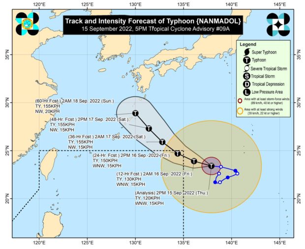
Track of Severe Tropical Storm Namnadol
Updated 11:28 PM
MANILA, Philippines — Severe tropical storm “Nanmadol” intensified into a typhoon on Thursday afternoon, the Philippine Atmospheric Geophysical and Astronomical Services Administration (Pagasa) said in its latest advisory.
Pagasa said Nanmadol reached the typhoon category at around 2:00 pm.
The center of the Nanmadol was estimated at 1,665 km east northeast of extreme Northern Luzon, packing maximum sustained winds of 120 kilometers per hour (kph) with gustiness of up to 150 kph.
Once it enters, the severe tropical storm will be called “Josie.”
Pagasa further said that Nanmadol may enter the Philippine Area of Responsibility (PAR) region on Thursday night or Friday morning.
“On the track forecast, it may enter the [PAR] region tonight or tomorrow morning,” the state weather service said. “Nanmadol is forecast to reach typhoon category within 12 to 24 hours.”
Nanmadol is far from the country’s landmass, Pagasa said, but it will enhance the southwest monsoon – locally termed “habagat” – thus, rain may be anticipated over several parts of the country.
“This severe tropical storm is forecast to remain far from the Philippine landmass and not directly affect the weather condition in the country. However, the Southwest Monsoon enhanced by Nanmadol will bring monsoon rains over the western sections of Southern Luzon, Visayas, and Mindanao,” Pagasa said.
Further, Pagasa explained that the enhancement of the southwest monsoon “may also bring gusty conditions reaching strong breeze to near-gale strength,”, especially in coastal and mountainous or upland areas of Visayas, Mimaropa, Bicol Region, and the northern and western portions of Mindanao.