


STS Inday intensifies, will be nearest to Batanes by Sunday — Pagasa
Track of STS Inday. Image from Pagasa
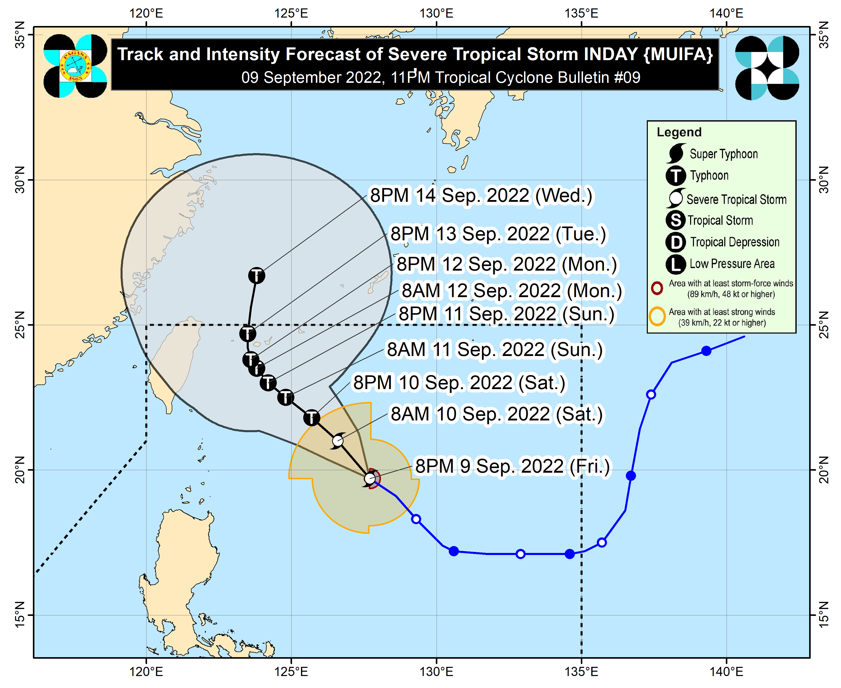
MANILA, Philippines — Severe Tropical Storm Inday intensified further as it moves closer to Batanes before making its way north, but the weather bureau said it is not expected to make landfall.
Updates from the Philippine Atmospheric, Geophysical and Astronomical Services Administration (Pagasa) on Friday night showed that Inday was last located 595 kilometers east of Basco, Batanes, packing maximum sustained winds of 110 kilometers per hour (kph) and gustiness of up to 135 kph. It is currently moving northwest at a speed of 10 kph.
Weather specialist Benison Estareja said a landfall scenario is not expected as its forecast track shows that even if the cyclone veers southwest, it would only hit waters north of Batanes.
However, its trough would still bring strong winds and occasional rains, and it would be nearest to Batanes on Sunday.
“Wala pa rin tayong nakikitang landfall scenario dito sa anumang panig ng Luzon or even direct effect. Kung mapapansin po natin ‘yong ating cone of uncertainty or probability ay nag-eextend dito lamang po sa North Philippine Sea at wala dito sa parteng Luzon,” Estareja said.
(We still have not seen any landfall scenario or even any direct effect for any part of Luzon. According to our cone of uncertainty or probability, the possible track only extends up to the North Philippine Sea at it would not touch the landmass of northern Luzon.)
“Pinakamalapit sa Batanes itong bagyo pagsapit po ng Linggo, at around 300 to 350 kilometers po northeast ng Batanes,” he added.
(It would be nearest to Batanes by Sunday, at around 300 to 350 kilometers northwest of Batanes.)
Still, Inday’s trough and the intensified southwest monsoon is expected to bring rains over parts of Luzon, especially as the cyclone is expected to intensify further into a typhoon before leaving the Philippine area of responsibility between Sunday night and Monday morning.
“Kita po dito sa ating satellite animation ‘yong mga pag-uulan dulot ng trough or ‘yong extension nitong si Bagyong Inday […] pero ‘yong indirect effect, itong mga pag-ulan na nararanasan natin ngayong gabi hanggang sa mga susunod pa na araw ay dahil po doon sa extension or trough nitong si Bagyong Inday,” Estareja said.
(We can see in our satellite animation that there are rains brought by the trough or extension of Severe Tropical Storm Inday […] but the indirect effect, the rains we are experiencing tonight and the coming days are brought by the extension or trough of Inday.)
“So inaasahan natin meron pa ring mga indirect effect ‘yong pag-enhance po ng habagat or ‘yong southwest monsoon,” he added.
(So we expect as an indirect effect the enhancement of the habagat or the southwest monsoon.)
No heavy and widespread rains are expected, but Inday may bring rough seas especially over the seaboards of Batanes and Babuyan Islands, with waves reaching heights of up to 2.0 meters to 4.0 meters in Batanes.
Pagasa warned that these conditions may make traveling over waters near the extreme Northern Luzon, especially for small boats, not possible.


