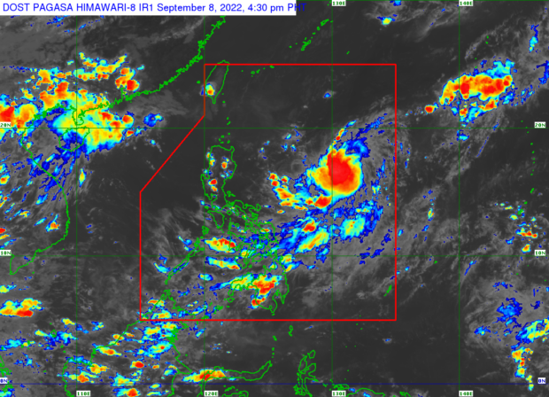
PHOTO FROM DOST-PAGASA
MANILA, Philippines — Tropical Storm Inday (international name: Muifa) will not directly affect the country’s weather condition, but its “extension” or trough will bring rain over Eastern Visayas, the state weather bureau said Thursday afternoon.
The Philippine Atmospheric, Geophysical and Astronomical Services Administration (Pagasa) said in a briefing that “Inday” was last located 1,055 kilometers east of Northern Luzon, packing maximum sustained winds of 75 kilometers per hour (kph) near the center and gustiness of up to 90 kph.
It is moving westward at 20 kph, Pagasa added.
State weather service specialist Raymond Ordinario also noted that Inday remains stationary east of the Philippine Sea and will not directly impact the country.
“Ang nakita lang natin ngayong hapon ay itong humahabang trough ng bagyong Inday ay nakakaapekto na ngayon sa Eastern Visayas kaya inaasahan natin diyan sa eastern Visayas na magkakaroon ng maulap na papawirin na may mga kalat-kalat na pag-ulan, pagkidlat at pagkulog,” he explained.
(What we saw this afternoon, however, is the expanding trough of Inday, which is now affecting Eastern Visayas. With this, we’re expecting overcast skies with scattered rain, lightning, and thunder in the area.)
On the other hand, fair weather with isolated rains will prevail over the rest of the country, including Metro Manila, Ordinario added.
Pagasa said Inday is seen to intensify into a severe tropical storm within the next 24 hours. It also said that the weather event is anticipated to leave the Philippine area of responsibility (PAR) by Sunday or Monday.
“Inaasahan natin na ang exit from PAR ay either Sunday o Monday pero nakikita natin na possible, by Monday na ito tuluyang lalabas ng PAR kung hindi pa rin magbabago iyong kanyang magiging galaw sa mga susunod na oras,” Ordinario further explained.
(We’re expecting it to exit the PAR either on Sunday or Monday, but it’s possible that by Monday, it will be completely outside the PAR unless its pattern of movement changes in the next few hours.)
Meanwhile, Pagasa issued temperature ranges for Friday in various cities and areas of the country:
- Metro Manila — 25 to 33 degrees Celsius
- Baguio — 17 to 23 degrees Celsius
- Laoag — 25 to 32 degrees Celsius
- Tuguegarao — 24 to 34 degrees Celsius
- Legazpi — 25 to 31 degrees Celsius
- Puerto Princesa — 25 to 32 degrees Celsius
- Tagaytay — 23 to 32 degrees Celsius
- Kalayaan Islands — 26 to 33 degrees Celsius
- Iloilo — 25 to 32 degrees Celsius
- Cebu — 25 to 32 degrees Celsius
- Tacloban — 25 to 31 degrees Celsius
- Cagayan de Oro — 23 to 31 degrees Celsius
- Zamboanga — 25 to 33 degrees Celsius
- Davao — 25 to 32 degrees Celsius
RELATED STORY
Tropical Storm enters PAR, now called ‘Inday’


