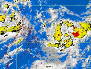
MANILA, Philippines – Tropical depression “Egay” continues to exhibit the trappings of a coy storm as it stays on track while moving away from the Philippines, but dumping heavy rains and winds in its wake, forcing the Philippine Atmospheric, Geophysical and Astronomical Services Administration (Pagasa) to keep storm signal 1 hoisted over many parts of a shivering northern Luzon.
In its latest weather advisory, Pagasa said that Egay was seen 250 kilometers Northwest of Aparri, Cagayan or 210 kilometers West of Basco, Batanes.
It has kept its strength with maximum sustained winds of 55 kilometers per hour near the center, and is forecast to move west northwestward at 17 kph.
Signal number 1 remains raised over Ilocos Norte, Calayan, Babuyan group of islands and Batanes group of islands, Pagasa said.
The good news is that storm signal warnings elsewhere have been lowered, the state-run weather bureau said.
But residents in low-lying and mountainous areas under signal number 1 are still reminded to be cautious, and be on alert for possible flash floods and landslides.
Those living in the western sections of Luzon and the Visayas will expect more rains as Egay swirls away from the country, no thanks to the enhanced southwest monsoon that trails it as it departs.
Meanwhile, another low pressure area was seen by Pagasa 1,020 kilometers east of Southern Visayas. This could develop into another wet experience for the Philippines in the coming days, and Pagasa says it will keep the country posted of future developments.
As for blushing Egay, it is expected to bring its wet and windy ways out of the country, some 400 kilometers to be exact, northwest of Aparri, Cagayan, or 370 kilometers west of Basco, Batanes, by Monday evening.
