


‘Florita’ now over coastal waters of Ilocos Norte, says Pagasa
Source: DOST / Pagasa
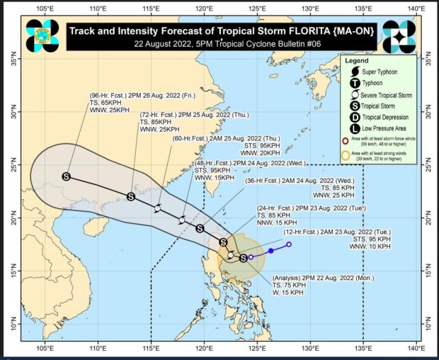
MANILA, Philippines — Severe Tropical Storm “Florita” (international name: Ma-on) is now over the coastal waters of Burgos, Ilocos Norte, as it maintains its strength, the state meteorologist said on Tuesday.
In its 8 p.m. update, the Philippine Atmospheric, Geophysical and Astronomical Services Administration (Pagasa) said Florita was last seen over the coastal waters of Burgos, Ilocos Norte, packing maximum sustained winds of 100 kilometers per hour (kph) near the center with gustiness of up to 165 kph.
Pagasa said Florita is forecast to move west-northwestward throughout the forecast period and may exit the Philippine area of responsibility on Wednesday morning, but is estimated to re-intensify and may reach typhoon category on Wednesday afternoon.
Pagasa said that due to Florita, winds may reach storm-force in strength in any of the areas where Tropical Cyclone Wind Signal (TCWS) No. 3 is hoisted; while winds may reach gale-force in strength in any of the areas where TCWS No. 2 is hoisted; while strong winds with strong breeze to near gale strength will be experienced within any of the areas where TCWS No. 1 is currently in effect.
Here are the areas under TCWS No. 3, where storm-force winds prevailing or expected within 18 hours, which could cause moderate to a significant threat to life and property:
- Northwestern portion of mainland Cagayan (Ballesteros, Pamplona, Abulug, Sanchez-Mira, Claveria, Santa Praxedes)
- Southwestern portion of Babuyan Islands (Camiguin Is., Dalupiri Is)
- Northern and central portions of Apayao (Calanasan, Kabugao, Luna, Pudtol, Flora, Santa Marcela)
- Ilocos Norte
Here are the areas under TCWS No. 2, where gale-force winds prevailing or expected within 24 hours that could cause minor to moderate threat to life and property:
Northern and central portions of Ilocos Sur (Quirino, Gregorio del Pilar, Salcedo, Santa Lucia, Galimuyod, City of Candon, San Emilio, Lidlidda, Banayoyo, Santiago, Burgos, San Esteban, Santa Maria, Nagbukel, Narvacan, Santa, Santa Catalina, San Vicente, Bantay, Santo Domingo, San Ildefonso, Caoayan, City of Vigan, Magsingal, San Juan, Cabugao, Sinait)
- Rest of Apayao,
- Kalinga
- Abra
- Northern portion of Mountain Province (Besao, Sagada, Bontoc, Sadanga, Barlig, Natonin, Paracelis)
- Rest of mainland Cagayan
- Rest of Babuyan Islands
- Northern portion of Isabela (Roxas, Quirino, Tumauini, Delfin Albano, Mallig, Quezon, Santo Tomas, Cabagan, Santa Maria, San Pablo, Maconacon)
Here are the areas under TCWS No. 1, where strong winds are prevailing or expected within 36 hours, which could only cause minimal to a minor threat to life and property:
- Batanes
- Rest of Isabela
- Nueva Vizcaya
- Quirino
- Rest of Mountain Province
- Ifugao
- Benguet
- La Union
- Rest of Ilocos Sur
- Northern and central portions of Aurora (Dipaculao, Dinalungan, Casiguran, Dilasag)
TROPICAL CYCLONE BULLETIN NO. 15Severe Tropical Storm “#FloritaPH” (MA-ON)Issued at 8:00 PM, 23 August 2022Valid for…
Posted by Dost_pagasa on Tuesday, August 23, 2022
RELATED STORY:
‘Florita’ slightly weakens, may exit PH on Wednesday – Pagasa


