More areas placed under Signal No. 3; ‘Florita’ makes landfall in Isabela

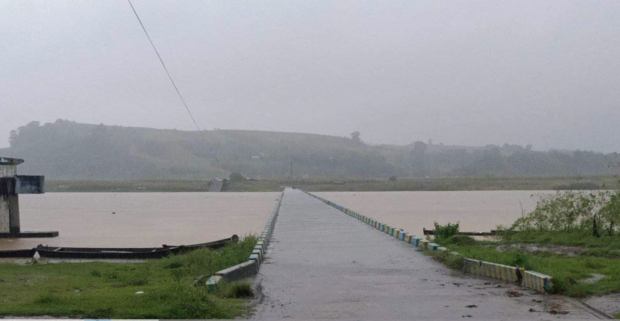
As of 6am, August 23, 2022, Baculud and Cabisera 8 overflow bridges remain passable to all vehicles, but all were advised to proceed with extreme CAUTION as there is a noticeable increase in water levels. Image from City of Ilagan DRRMO – Rescue 1124 / Facebook
MANILA, Philippines — More areas were placed under Tropical Cyclone Wind Signal No. 3 as Severe Tropical Storm Florita further intensified and made landfall over Maconacon, Isabela on Tuesday.
According to the Philippine Atmospheric, Geophysical and Astronomical Services Administration (Pagasa), Florita was spotted over the coastal waters of Maconacon, Isabela as of 10 a.m. and made landfall at 10:30 a.m.
READ: Signal No. 3 raised as ‘Florita’ intensifies into a severe tropical storm
Moving northwestward at 20 kilometers per hour (kph), Florita packs maximum sustained winds of 110 kph and gustiness of up to 150 kph.
Below are the areas where tropical cyclone wind signals are hoisted:
Signal No. 3
-northern portion of Ilocos Norte (Pagudpud, Dumalneg, Adams, Bangui, Burgos)
-Apayao
-southern portion of Babuyan Islands (Camiguin Island, Fuga Island, Dalupiri Island)
-mainland Cagayan
-northeastern portion of Isabela (Palanan, Divilacan, Maconacon, San Pablo, Tumauini, Cabagan, Santa Maria, Santo Tomas, Delfin Albano, Ilagan City, San Mariano)
Signal No. 2
-rest of Babuyan Islands
-rest of Isabela
-Quirino
-northern and eastern portion of Nueva Vizcaya (Quezon, Diadi, Bagabag, Villaverde, Solano, Kasibu)
-Abra
-Kalinga
-Mountain Province
-Ifugao
-northern portion of Benguet (Buguias, Bakun, Mankayan, Kibungan)
-rest of Ilocos Norte
-Ilocos Sur
-northern portion of Aurora (Dilasag, Casiguran, Dinalungan, Dipaculao)
Signal No. 1
-Batanes
-rest of Nueva Vizcaya
-rest of Benguet
-La Union
-eastern portion of Pangasinan (Santo Tomas, Villasis, Mapandan, Mangaldan, San Fabian, San Jacinto, Manaoag, City of Urdaneta, Rosales, Balungao, Umingan, San Quintin, Natividad, San Nicolas, Tayug, Santa Maria, Asingan, San Manuel, Binalonan, Sison, Pozzurrubio, Laoac, Dagupan City)
-northeastern portion of Tarlac (San Manuel, Anao)
-Nueva Ecija
-rest of Aurora
Heavy to intense with at times torrential rains are expected over Cagayan, Isabela, Cordillera Administrative Region, Ilocos Region, Zambales, and Bataan.
Meanwhile, moderate to heavy with at times intense rains may be experienced over the northern portion of Aurora, Tarlac, Pampanga, Bulacan, Metro Manila, Cavite, Rizal, and the rest of Cagayan Valley.
The rest of Central Luzon and Calabarzon (Cavite, Laguna, Batangas, Rizal, Quezon) will have light to moderate with at times heavy rains.
Florita is expected to leave the Philippine Area of Responsibility on Wednesday morning, Pagasa said.