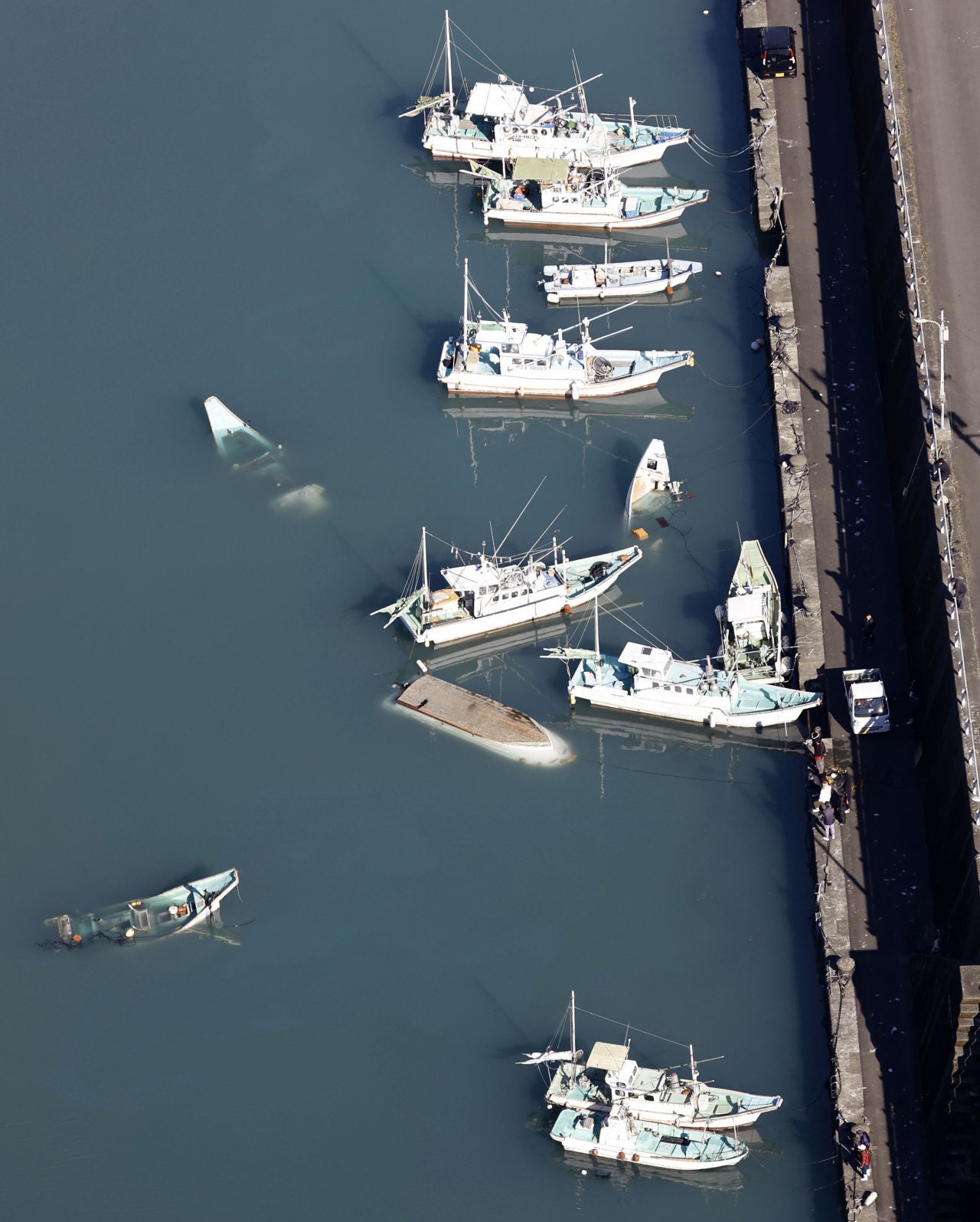
Boats capsized by a tsunami is seen on Sunday at a port in the city of Muroto, Kochi Prefecture. | PHOTO: Yonhap via The Korea Herald/Asia News Network
SEOUL — An underwater volcanic eruption in the South Pacific which triggered massive waves reaching as far as Japan and the West Coast of the US has left Koreans wondering one thing: Is the Korean Peninsula safe?
Experts say the possibility of the country’s coastal region being wiped out by a tsunami is relatively low, due to its geographic location.
The Korean Peninsula is shielded by Japan on the east. For any tsunami originating in the Pacific to reach Korea, it would have to go through the island nation first.
Of course, not all quakes happen in the faraway seas. If a strong quake occurs, say, on the west side of Japan, or in the sea between mainland China and Korea, Korea can be vulnerable.
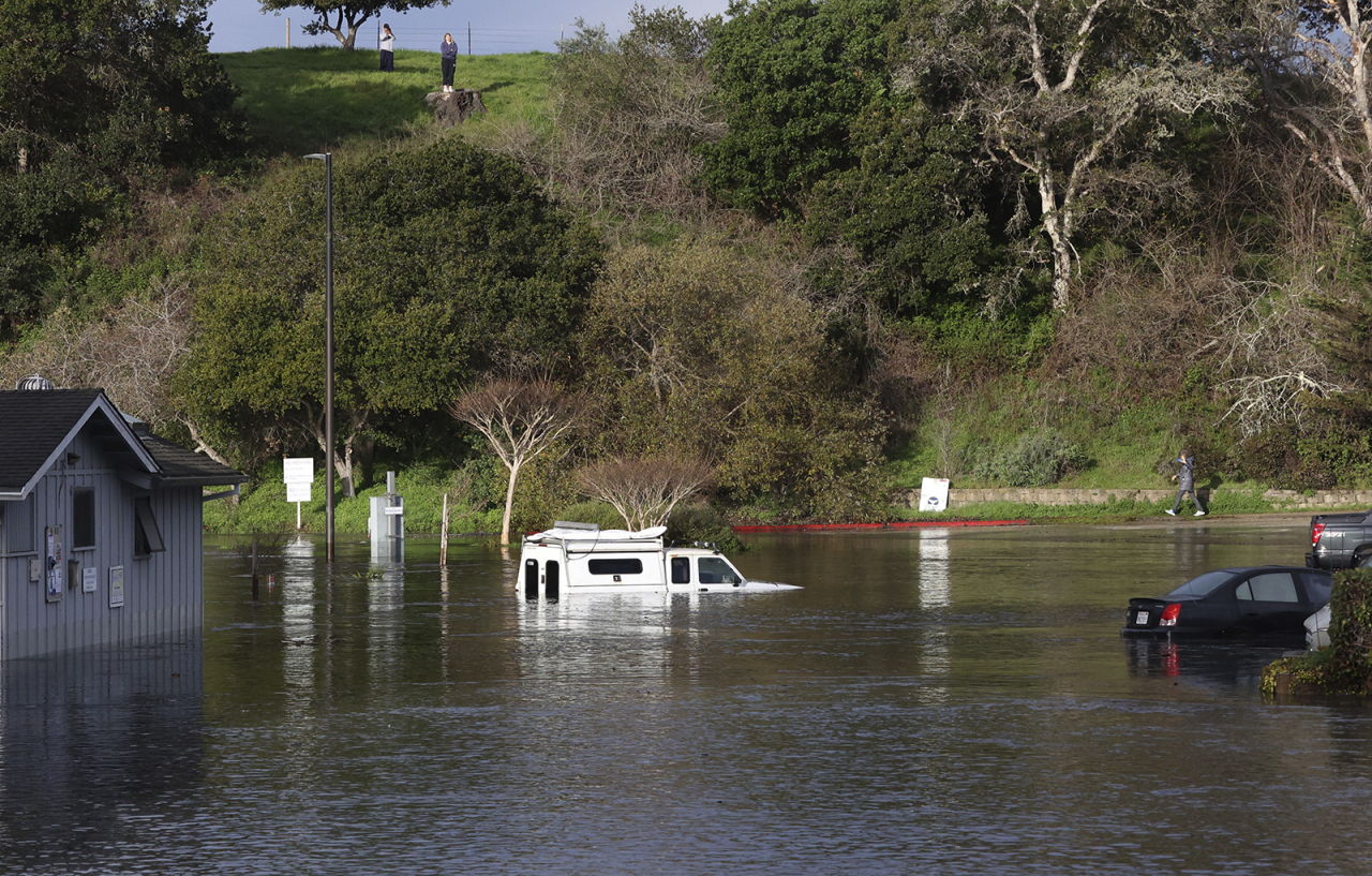
A tsunami surge inundates the parking lot at the top of the Upper Harbor in Santa Cruz, California on Saturday. | PHOTO: Yonhap via The Korea Herald/Asia News Network
Data shows this is not a mere theory.
Records of the Joseon Dynasty (1392-1910) show multiple cases of earthquake-induced waves in the 17th century, with one in July 31, 1668 in Pyeongan Province — now part of North Korea — being caused by the earthquake in China’s Shandong region.
Since 1900, there have been four recorded cases of tsunamis that originated in the East Sea, the body of water separating Korea and Japan, that caused substantial damage in Korea. The most recent one was caused by a magnitude 7.8 earthquake near the Japanese island of Hokkaido, which destroyed 53 fishing boats on the island of Ulleungdo and in coastal cities of Sokcho, Donghae and Pohang. The 1983 tsunami claimed three casualties and 400 million won ($335,000) in property damage, which would amount to 1.45 billion won in today’s money.
After a magnitude 9.1 megathrust earthquake hit Japan’s Tohoku region in 2011, Korean authorities commissioned several studies to assess how vulnerable Korea was to similar threats.
One of the results is a report published by the National Disaster Management Research Institute in 2013. The study, titled “Improvement of tsunami response system with the analysis of tsunami risk elements in Korea,” says while Korea’s location makes it less vulnerable to quakes and tsunamis, there exists a rare case scenario with potentially devastating impacts.
“The Korean Peninsula is located on the edge of the Eurasians Plate (the tectonic plate including most of Eurasia), and has been considered safer than Japan which is located between plates…But this (safety) is merely relative as research shows that the peninsula is not a safe zone from earthquakes,” researchers wrote, adding that Japan is located where the Eurasian Plate meets the Pacific Plate, making it susceptible to earthquakes and ensuing tsunami.
The NDMI report goes on to say that there have been 165 cases of underwater earthquakes from 1978 to 2012 with magnitudes of 3.0 or higher, accounting for 51 percent of all earthquakes near the Korean Peninsula. While most of these quakes are not strong enough to cause a tsunami, the report stressed the need for countermeasures since the epicenter for many of them were close to the coastal area.
In 2016, South Korea was rattled by a magnitude 5.0 underwater earthquake near Ulsan, in the country’s southeastern region, although it did not cause a tsunami.
An analysis by the Korea Meteorological Administration shows that an earthquake in excess of magnitude 6.5 that occurs in Korea’s east coastal area can trigger a tsunami that could cause substantial damage. A magnitude 6.6 quake can create a tidal wave that is half-a-meter in height.
It would take a much stronger quake — around 7.5 to 7.8 — in the shallower West Sea to cause a tsunami to affect the peninsula. The aforementioned 1993 tsunami was three meters high and was caused by a magnitude 7.8 earthquake.
While a large-scale earthquake is unlikely around the Korean Peninsula, the country is also vulnerable to the aftermath of the quakes that occur in Japan’s west coast, which is much more susceptible to tremors.
The National Fire Agency operates a Tsunami Disaster Response System that analyzes earthquakes that occur in the coastal regions, and predicts the ensuing tsunami’s height, the areas expected to be affected and the estimated time of arrival. It is based on a database from 43 populated areas mostly in the east coast, which had been hit the most with tidal waves and are the most vulnerable.
The KMA issues two-level warnings for tsunamis, one for tidal waves between 0.5 meters and 1 meter in height, and for one exceeding 1 meter.