Signal No. 3 up in 4 areas in Mindanao as a slower Typhoon Odette intensifies
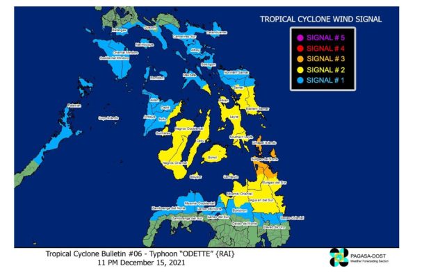
MANILA, Philippines — Four areas in Mindanao were put under Storm Signal No. 3 as Typhoon Odette (internationally known as Rai) slowed down but slightly intensified on Wednesday evening, according to the 11 p.m. bulletin issued by the Philippine Atmospheric Geophysical and Astronomical Services Administration’s (Pagasa).
The eye of the typhoon was last located 470 km east of Surigao City, Surigao Del Norte.
It was blowing maximum sustained winds of 140 kph with gusts reaching up to 170 kph, but it slowed down as it continued to move westward at 15 kph.
As of this writing, it neared making landfall in the vicinity of the northeastern part of Mindanao — Surigao del Norte, Surigao del Sur, and Dinagat Islands — or the southern part of Eastern Visayas on Thursday afternoon, Dec. 16.
Signal No. 3 has been raised in the following four areas in Mindanao, where the typhoon is expected to carry destructive winds within the next 18 hours:
• Dinagat Islands
• Surigao del Norte
• northern portion of Agusan del Norte — Tubay, Santiago, Jabonga, Kitcharao
• northern portion of Surigao del Sur — Carrascal, Cantilan, Madrid, Carmen, Lanuza, Cortes
Signal No. 2 has been raised in 19 areas, where damaging gale-to-storm-force winds are then expected within 24 hours:
Luzon
• southeastern portion of Masbate – Cataingan, Pio V. Corpuz, Esperanza, Placer
Visayas
• central and southern portions of Eastern Samar – Guiuan, Salcedo, Quinapondan, Giporlos, Balangiga, Lawaan, General Macarthur, Hernani, Llorente, Balangkayan, Maydolong, City of Borongan, San Julian, Sulat, Taft, CanAvid, Mercedes
• central and southern portions of Samar – Marabut, Basey, Santa Rita, Villareal, Pinabacdao, Calbiga, Hinabangan, Paranas, Motiong, Jiabong, City of Catbalogan, San Sebastian, Zumarraga, Daram, Talalora, San Jorge, Tarangnan, Pagsanghan, Santo Niño, Almagro, Tagapul-An
• Biliran
• Leyte
• Southern Leyte
• Cebu
• Bohol
• Negros Oriental
• Siquijor
• Negros Occidental
• Guimaras
• Eastern portion of Iloilo — Carles, Balasan, Batad, Estancia, San Dionisio, Concepcion, Sara, Ajuy, Lemery, San Rafael, Banate, Anilao, Barotac Viejo, Barotac Nuevo, Dumangas
Mindanao
• rest of Surigao del Sur
• rest of Agusan del Norte
• Agusan del Sur
• northern portion of Bukidnon — Malitbog, Impasug-Ong, Manolo Fortich
• eastern and central portions of Misamis Oriental — Tagoloan, Villanueva, Jasaan, Claveria, Balingasag, Lagonglong, Balingoan, Talisayan, Medina, Gingoog City, Magsaysay, Kinoguitan, Sugbongcogon, Binuangan, Salay, Cagayan de Oro City, Opol, City of El Salvador, Alubijid, Laguindingan, Gitagum, Libertad
• Camiguin
Signal No. 1 has been raised in the following areas, where strong winds are expected to prevail within the next 36 hours:
Luzon
• Catanduanes
• Camarines Sur
• Albay
• Sorsogon
• rest of Masbate including Ticao and Burias Islands
• Marinduque
• Romblon
• southern portion of Quezon — San Antonio, Tiaong, Candelaria, Sariaya, Dolores, Lucena City, Pagbilao, Padre Burgos, Atimonan, Agdangan, Unisan, Gumaca, Plaridel, Pitogo, Lopez, Guinayangan, Buenavista, Catanauan, General Luna, Macalelon, Mulanay, San Narciso, San Andres, San Francisco
• southern portion of Batangas – San Juan, Lobo, Taysan, Rosario, Padre Garcia, Ibaan, Batangas City, San Pascual, San Luis, Bauan, Mabini, Tingloy, Calatagan
• Oriental Mindoro
• Occidental Mindoro
northern and central portions of Palawan — San Vicente, Roxas, Taytay, Dumaran, Araceli, El Nido, Puerto Princesa City — including Calamian, Cagayancillo, and Cuyo Islands
Visayas
• Northern Samar
• rest of Eastern Samar
• rest of Samar
• Aklan
• Antique
• Capiz
• rest of Iloilo
Mindanao
• northern portion of Davao Oriental — Boston, Cateel
• northern portion of Davao de Oro — Monkayo, Compostela, Montevista, Laak
• northern portion of Davao del Norte — San Isidro, Kapalong
• Rest of Misamis Oriental
• Misamis Occidental
• central portion of Bukidnon — Talakag, Lantapan, City of Valencia, City of Malaybalay, San Fernando, Cabanglasan, Libona, Baungon, Sumilao
• northern portion of Lanao del Norte — Baroy, Tubod, Kolambugan, Magsaysay, Tangcal, Munai, Maigo, Bacolod, Kauswagan, Poona Piagapo, Pantao Ragat, Matungao, Baloi, Iligan City, Linamon, Tagoloan, Pantar
• northern portion of Lanao del Sur — Madalum, Bacolod-Kalawi, Tugaya, Balindong, Piagapo, Saguiaran, Marantao, Marawi City, Kapai, Tagoloan II, Bubong, Ditsaan-Ramain, Buadiposo-Buntong
• northern portion of Zamboanga del Norte — Labason, Kalawit, Tampilisan, Liloy, Salug, Godod, Bacungan, Sindangan, Siayan, Jose Dalman, Manukan, Pres. Manuel A. Roxas, Katipunan, Sergio Osmeña Sr., Dipolog City, Polanco, Piñan, Mutia, La Libertad, Dapitan City, Sibutad, Rizal, Gutalac, Baliguian
• northern portion of Zamboanga del Sur (Dumingag, Ramon Magsaysay, Midsalip, Sominot, Mahayag, Molave, Josefina, Tambulig
Pagasa warned the public to expect on Thursday heavy to intense with at times torrential rainfall over Central Visayas, Western Visayas, and Palawan including Calamian Islands, Cuyo, and Cagayancillo Islands.
Meanwhile, moderate to heavy with at times intense rainfall is expected over Bicol Region, Zamboanga Peninsula, Occidental Mindoro, Oriental Mindoro, Romblon, Lanao del Norte, Lanao del Sur, and the rest of the Visayas.
Light to moderate with at times heavy rainfall is expected over Caraga, Quezon, the southern portion of Aurora, and the rest of Northern Mindanao and Mimaropa.