Proof of life in Taal’s wasteland

DISCOVERY: Researchers from the University of the Philippines-National Institute of Geological Sciences (UP-NIGS) and FAITH (First Asia Institute of Technology and Humanities) Colleges discover a large base surge deposit exposed on a hill cut that suggests a historical eruption of a much larger scale than that of the January 2020 eruption of Taal Volcano in Batangas province. (Photo by RICHARD YBAÑEZ / UP-NIGS)
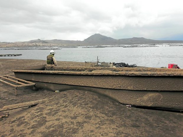
Riding in three single-hulled outriggers and challenging choppy waters, a dozen eager members of a scientific expedition team finally reached Kalawit’s beach of gray volcanic sand on the southeast flank of Taal Volcano Island past noon. The scientists were to climb anew to the edge of the crater just over a year after the volcano erupted on Jan. 12, 2020, on a mission of rediscovering land, life and growth after the fury.
Kalawit, once a thriving farming and fishing village and part of Balete, Batangas province, remained a scene of barren landscape and desolation. Ash coated the abandoned houses of concrete and wood, as deep as 2 meters in some. A school house that lost its roof had rooms full of volcanic sand, not pupils. On its outer walls was a pasty volcanic deposit the team identified and named “ludite,” a new term in volcanological literature. Toppled trees hunkered down outside the structures and had yet to show signs of foliation.
Taal’s eruption — the first of one of the country’s active volcanoes in 43 years — sent 540 families in the village, as well as 135,000 people in surrounding lakeside communities, fleeing to safe shelters and disrupting local life. One person was killed directly, and the blast left an expansive, eerie graveyard of livestock and vegetation in the immediate vicinity.
ALTERED LANDSCAPE The eruption of Taal Volcano in January last year has altered the landscape of the island, displacing the more than 5,000 people that for generations called it home. —MARIO AURELIO
Base surges
Kalawit was buried in what scientists call a “base surge deposit,” or rock and sand fragments, spewed from the mouth of Taal Volcano and swept by extremely hot water down its flanks at a speed faster than a car racing at more than 200 kilometers per hour. Surges often accompany a “phreatomagmatic” eruption, when water mixes with rising magma in the subsurface.
Farther up in Barangay Baluarte on the southern rim of the caldera, at least 100 meters above sea level, a hill cut exposed another base surge deposit thrice bigger than Kalawit’s. The vast preserved field was witness to an enormous explosion from a much larger volcanic edifice in the recent geologic past and will be vital in knowing when that violent upheaval occurred to get a better grasp of the eruptive history of the responsible volcano.
Article continues after this advertisementBase surges are among the deadliest and most destructive hazards of volcanic eruptions. So far, six of the 34 recorded Taal eruptions since 1572 had produced distinct base surges, claiming the lives of thousands in 1716, 1731, 1749, 1754, 1911 and 1965. No similar account on the seventh base surge from the 2020 explosion had been made until it was discovered accidentally by the ecological expedition team that climbed the volcano in December 2020.
Article continues after this advertisementThe finding “is a rare document of a complete, fresh and practically undisturbed base surge deposit, important in the study of dune deposits formed by volcanic and other processes on Earth and other planets,” according to the team’s report, “Hazardous base surges of Taal’s 2020 eruption” published in Nature’s Scientific Reports. Field data can describe “dune bedform characteristics, impact dynamic pressures and velocities of base surges,” the report said, pointing out that it may help better understand and evaluate the hazard’s consequences and risks.
Using satellite and drone technologies, the base surges were mapped, their thickness and volume determined by comparing data measured with light detection and ranging before the eruption and drone-derived digital terrain models after.
The latest base surges flowed at speeds of 50 to 60 meters per second (180 to 216 kph) near the crater and slowed down before reaching the coastal communities with dynamic pressures of at least 1.7 to 2.1 kilopascals, still strong enough to splinter bamboo, a plant which is otherwise pliant at normal pressures.
More than a thousand livestock were killed in the southeast of the volcano, and the base surges traveled another 600 m offshore.
“The dune field in the southeast sector offer a rare, largely undisturbed, and nearly complete picture of a base surge deposit field,” the report said. “Often, these deposits are studied as discontinuous outcrops years after an eruptive event, when erosion, deposition and vegetation have obliterated or concealed important features that hinder better understanding of flow emplacement and dynamics.”
Once unraveled, information about the Baluarte base surge can be useful in evaluating the hazards of a potential next eruption and will define the research team’s future undertakings. For now, the team surmised that if it emanated from approximately the same location of present-day Taal Island, the volcanic source could have been much more enormous that in case of an eruption in current times, surges may engulf many populous towns on the outer shores of Taal Lake.
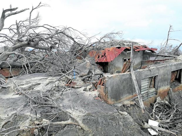
DESOLATION A house surrounded by dead trees is buried by base surge deposits in Barangay Kalawit on Taal Volcano Island. —MARIO AURELIO
Ashfall, ground fissures
The 2020 eruption also expelled ash plumes reaching 17 to 21 km up in the air and blown by “high-elevation winds” northward to as far as about 100 km away to build deposits in the City of Meycauayan in Bulacan province, Tanay in Rizal province, and other areas. Also known as jet streams, the winds of exceedingly high speeds exist in narrow bands in the atmosphere at altitudes of at least 3.7 to 7.5 km (20,000 to 40,000 feet).
While ashfall, the most widespread and frequent volcanic hazard, may be much less disastrous than base surges, it can over time smother vegetation and render land and water bodies unproductive in areas closest to the volcano, like Agoncillo, Batangas. In Tagaytay City, it took time to clear ash-laden roofs in condominium complexes and residential enclaves.
Ash deposits were thicker in a relatively narrow field southwest of the volcano than in a much wider and farther area northeast, suggesting that prevailing winds would be an important factor in ashfall deposition and setting of mitigating measures in future eruptions.
When Taal erupted, kilometerslong fissures appeared in the towns of Calaca, Lemery, San Nicolas, Agoncillo and Talisay. Some of these continue to widen to this day, entombing entire houses along their traces. The second climb to the volcano was particularly aimed at flying drone missions over an area suspected to be the continuation of the ground fissures seen on the outer lakeshore towns, particularly on the island’s highest elevations, the twin peaks of Mt. Taal locally called “Dalawang Suso,” and Mt. Tabaro, where geology students on field classes usually took samples of recent lava flows.
Rapid ecological regrowth
Two life scientists, an entomologist and an ornithologist, who joined the team in February after begging off to climb up to the crater rim amid doubts of finding any forms of life yet there, were both surprised. Insects were already thriving, mostly two-winged diptera, or commonly called “flies,” that were attracted to the yellow security vests of the field men. A flight of insect-eating swallows hovered above, while egrets and other bird species were earlier spotted on the shores.
Several meters below the rim toward the crater lake, a few shrubs, a clump of weeds and a lone aroma shrub jutted out from the barren ground. This was a rare phenomenon, according to the life scientists, since plant species would need some time to regenerate after a volcanic episode, especially at the crater zone. Some of the regrowth, it turned out, came from survivors, or plants that did not completely burn during the eruption as suggested by a morinda tree, commonly known as “apatot,” where a lush of leaves sprouted from a broken twig of an otherwise burnt trunk.
The presence of plants and insects in the crater rim in so short a time was an encouraging sign of an earlier ecological recovery of the island. Unfortunately, the recovered ecosystem was, in an instant, obliterated anew by the more recent eruption of July 1, though low-scaled.
Choppy waters, gusty winds, suffocating ash, scorching heat—these are but some of the forces of nature that the research team had to contend with in exchange for scientific information. But these are nothing compared to the base surge deposits that rushed downhill on the southeastern flanks of Taal Volcano, burying Kalawit.
Scientific research improves our understanding of such forces, and volcanic eruption is one that Filipinos have to learn how to live with.
—CONTRIBUTED
(Editor’s Note: Mario A. Aurelio, Ph.D., who also writes for conserve.ph, is a professor from the University of the Philippines, or UP, and the director of the National Institute of Geological Sciences in UP Diliman. The scientific results of the Taal expeditions were published in Nature’s Scientific Reports and titled “Hazardous base surges of Taal’s 2020 eruption.” Assistance to the research expedition was extended by First Asia Institute of Technology and Humanities, or FAITH, Colleges, and Taal Volcano Island Conservancy.)