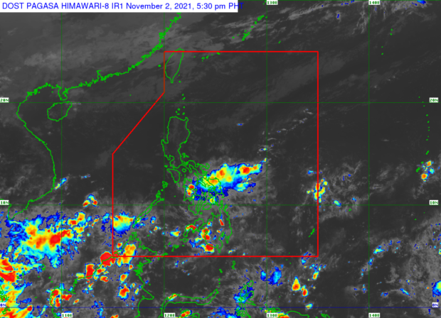

MANILA, Philippines — The low-pressure area (LPA) initially located in Butuan City, Agusan del Norte, may dissipate as it goes west toward Bohol province, the state weather service’s latest forecast on Tuesday afternoon indicated.

The Philippine Atmospheric, Geophysical, and Astronomical Services Administration (Pagasa) said the LPA was last spotted 45 kilometers southeast of Tagbilaran City, Bohol. Weather specialist Ariel Rojas said the LPA is not seen to develop into a typhoon as it may even disappear in the next 12 to 36 hours.
“Hindi inaasahan na magiging bagyo ang LPA na ito at posibleng in the next 12 to 36 hours ay malusaw din habang tumatawid patungo sa kanluran,” Rojas said.
(This LPA is not expected to become a typhoon and it is possible that in the next 12 to 36 hours it will dissolve while heading west.)
But since the LPA was moving west, Pagasa said Palawan is predicted to experience cloudy skies and heavy rain on Wednesday. The same weather conditions were also forecast over Bicol Region, but this will be due to a “shear line” or the point where the northeast monsoon and easterlies winds meet.
“May okasyon na malakas ang pagbuhos ng ulan in both areas, and posible ‘yan magdulot ng mga baha at pagguho ng lupa. Kaya ibayong pagiingat sa mga residente dito,” warned Rojas.
(There could be occasions of heavy rain in both areas, and it’s possible to cause floods and landslides. So, residents of these areas are advised to be extra careful.)
As for the rest of Luzon, including Metro Manila, Pagasa said generally fair weather may prevail in these areas on Wednesday although the chances of light rains still exist as it is the “signature” of the northeast monsoon, colloquially known as the “amihan season,” according to Rojas.
The Visayas, on the other hand, will continue to experience rain and cloudy skies on Wednesday due to the LPA and the shear line, while the entire Mindanao region will experience generally fair weather with chances of thunderstorms by Wednesday afternoon and evening.
Besides the LPA, no tropical cyclones are expected to form inside the PAR in the next two or three days, according to Pagasa.

Meanwhile, the state weather bureau said the temperature range in key cities/areas across the country on Wednesday would be as follows:
- Metro Manila: 24 to 33 degrees Celsius
- Baguio City: 15 to 25 degrees Celsius
- Laoag City: 24 to 32 degrees Celsius
- Tuguegarao: 22 to 33 degrees Celsius
- Legazpi City: 25 to 31 degrees Celsius
- Puerto Princesa City: 25 to 31 degrees Celsius
- Tagaytay: 21 to 28 degrees Celsius
- Kalayaan Islands: 27 to 28 degrees Celsius
- Iloilo City: 24 to 30 degrees Celsius
- Cebu: 25 to 31 degrees Celsius
- Tacloban City: 25 to 31 degrees Celsius
- Cagayan De Oro City: 24 to 32 degrees Celsius
- Zamboanga City: 24 to 34 degrees Celsius
- Davao City: 25 to 32 degrees Celsius
Pagasa then said no gale warning is being raised over the coasts of the country but moderate to rough sea conditions may be expected in the northern and western seaboards of Luzon, while the situation will be moderate over the rest of the country’s open seas.
Slight to moderate sea conditions could be expected within the inland seas in Visayas and Mindanao, Pagasa added.