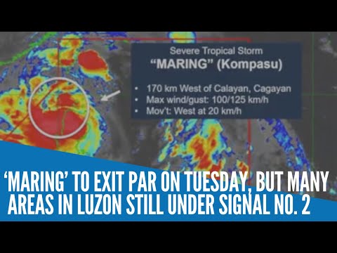
MANILA, Philippines — Severe tropical storm Maring is expected to exit the Philippine Area of Responsibility (PAR) on Tuesday but many areas in Northern Luzon are still under Tropical Cyclone Signal No. 2, the state weather bureau said.
Pagasa said the center of Maring is now estimated to be at 315 kilometers west of Calayan, Cagayan, and it is packing maximum sustained winds of 100 kilometers per hour (kph) near the center and gustiness of up to 125 kph.
Maring is moving westward at 20 kph and will continue to move westward over the West Philippine Sea throughout the forecast period.
“It is forecast to exit the Philippine Area of Responsibility (PAR) this morning,” Pagasa said in its advisory.
Meanwhile, the following areas are placed under TCWS No. 2 where damaging gale to storm-force winds are prevailing or expected within 24 hours:
- Batanes
- Cagayan including Babuyan Islands, the northern portion of Isabela (Palanan, Divilacan, Maconacon, Ilagan City, Tumauini, Cabagan, San Pablo, Santa Maria, Santo Tomas, Delfin Albano, Quirino, Gamu, Roxas, Mallig, Quezon)
- Apayao
- Kalinga
- Mountain Province
- Abra
- Ilocos Norte
- Ilocos Sur
These areas are under TCWS No. 1, where strong winds are now occurring or expected to happen within 36 hours:
- The rest of Isabela
- Nueva Vizcaya
- Quirino
- Ifugao
- Benguet
- La Union
- Pangasinan
- Aurora
- Nueva Ecija
- Tarlac
- Zambales
- Pampanga
- Bulacan, the northern portion of Bataan (Samal, Morong, Dinalupihan, Abucay, Orani, Hermosa)
- Northern portion of Quezon (General Nakar, Infanta) including Polillo Islands
The next tropical cyclone bulletin will be issued later this Tuesday at 5 p.m., according to Pagasa.


