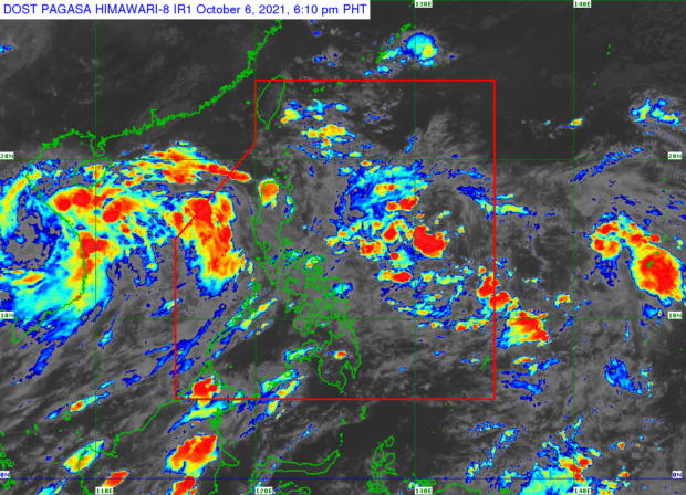
From the website of Pagasa
MANILA, Philippines — Tropical Depression Lannie has left the Philippine Area of Responsibility (PAR) on Wednesday morning but its trough would continue to bring rain over the western section of Luzon, including Metro Manila, on Thursday.
This was the forecast of the Philippine Atmospheric, Geophysical and Astronomical Services Administration (Pagasa) as it reported Lannie’s location to be at 710 kilometers (km) west of Subic, Zambales as of 3 p.m. Wednesday.
Pagasa weather specialist Joey Figuracion explained that the trough is the “extension” of Lannie’s “circulation.” He also said Lannie’s trough would cause scattered rain and lightning on Wednesday night over Metro Manila, Pangasinan, Bataan, Zambales, Tarlac, Pampanga, Cavite, Occidental Mindoro, Batangas, and Palawan.
“Bukas, ang Luzon ay apektado pa rin ng trough ng bagyo na nasa labas ng [PAR]. Generally, ‘yung kanlurang bahagi pa rin ng Luzon ang magkakaroon ng kalat-kalat na pagulan at thunderstorms,” Figuracion also said.
(Tomorrow, Luzon will still be affected by the trough of the typhoon that is already outside of PAR. Generally, the western part of Luzon will still have scattered rains and thunderstorms.)
“Samantala ‘yung nalalabing bahagi ng Luzon ay generally fair na ‘yung panahon. Kung may mga pag-ulan ay daglian lamang dahil ‘yan sa pamumuo ng thunderstorms,” he added.
(Meanwhile, the rest of Luzon will have generally fair weather. In case of rain, it would be brief because that’s due to the formation of thunderstorms.)
Pagasa also said generally fair weather would prevail across Visayas and Mindanao on Thursday although chances of rain due to localized thunderstorms were still likely.
On the other hand, the new low-pressure area being monitored by Pagasa has yet to enter PAR as it was located 1,310 kilometers east of Southern Luzon at 3 p.m. Wednesday.
“Maari po itong pumasok ngayong gabi o kaya naman madaling araw bukas, at maaari po ito maging bagyo sa Friday or Saturday bilang isang tropical depression,” Figuracion said.
(It may enter tonight or early tomorrow, and may transition into a typhoon on Friday or Saturday as a tropical depression.)
Once it becomes a typhoon within PAR, its local name would be “Maring,” the weather specialist said, adding that it is expected to move west-northwest towards Luzon.
But Figuracion said the latest readings indicate that the incoming typhoon has a “high uncertainty of landfall.”
Pagasa likewise released its temperature range predictions in key cities/areas of the country for Thursday as follows:
- Metro Manila: 25 to 31 degrees Celsius
- Baguio City: 16 to 22 degrees Celsius
- Laoag City: 25 to 30 degrees Celsius
- Tuguegarao: 24 to 32 degrees Celsius
- Legazpi City: 25 to 31 degrees Celsius
- Puerto Princesa City: 25 to 32 degrees Celsius
- Tagaytay: 22 to 29 degrees Celsius
- Kalayaan Islands: 25 to 30 degrees Celsius
- Iloilo City: 26 to 32 degrees Celsius
- Cebu: 24 to 32 degrees Celsius
- Tacloban City: 24 to 31 degrees Celsius
- Cagayan De Oro City: 24 to 32 degrees Celsius
- Zamboanga City: 24 to 33 degrees Celsius
- Davao City: 25 to 33 degrees Celsius
The state weather bureau said a gale warning remains up over the western seaboards of Palawan because rough to very rough sea conditions are expected in this area with waves possibly reaching up to 4.5 meters.
“Ipagpaliban na po muna ang paglalayag sa bahagi na iyan ng ating bansa dahil delikado po ang sitwasyon ng karagatan diyan,” said Figuracion.
(Refrain from sailing in this area of the country because the ocean’s situation there is dangerous.)


