
Share:


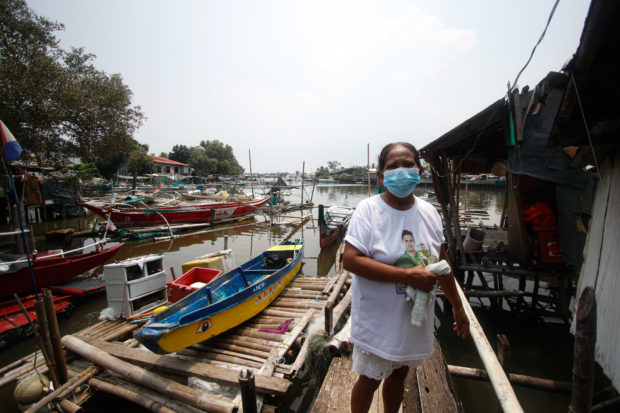
Odd-sized wooden stilts strain to keep Jocel Madrano’s house just over a meter above the gray polluted waters of Manila Bay. The shack, a patchwork of dilapidated plywood and partly anchored on a concrete seawall, is home to the 23-year-old mother of four.
On one Friday noon in July, Madrano was watching over her children and several of their cousins enjoying a television show, wondering what her family’s life would be like away from the sea.
She and her husband, who is four years her senior, earn barely enough to provide three meals a day for their family—he as a stevedore at the nearby port and she as a neighborhood manicurist.
This is not the life she wants for her children, the oldest, a boy just 6, and the youngest a 2-year-old toddler.
“We have thought of leaving,” said Madrano. “But where would we go?”
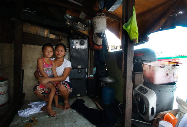
Jocel Madrano, 23, lives with her husband and four children in a shack built over Manila Bay, supported by wooden stilts. Despite their precarious living conditions, life goes on in this small community of around 100 families in Tondo, in the capital Manila. PHOTO BY AC DIMATATAC
But soon that difficult decision would have to be made. With stronger storms lashing their homes and the sea slowly rising, Madrano’s family and thousands of vulnerable communities along and near Metro Manila’s coasts may soon have to choose between either staying but risking the hunger of the sea, or leaving with no certainty or livelihood elsewhere.
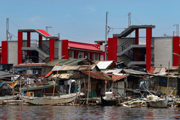
About 100 other families live in this ramshackle community on stilts literally on the edge of the seawall, almost out of sight from Radial Road 10, a major road running through Vitas, Tondo in the capital Manila.
Having lived all her life close to the water, Madrano knows it is dangerous for her children to have the sea right below the shanty’s rickety floorboards.
She knows it from experience, as a kid growing up beside the murky Estero de Vitas, one of the winding estuaries in Manila choking with garbage, and in the 12 years she has lived by the seawall.
She knows when to flee with her children to the safety of a basketball court across the road whenever strong typhoons and storm surges come. She knows that when the weather clears, her husband will have to reassemble remnants of their shack in a seemingly perpetual cycle of rebuilding against the odds.
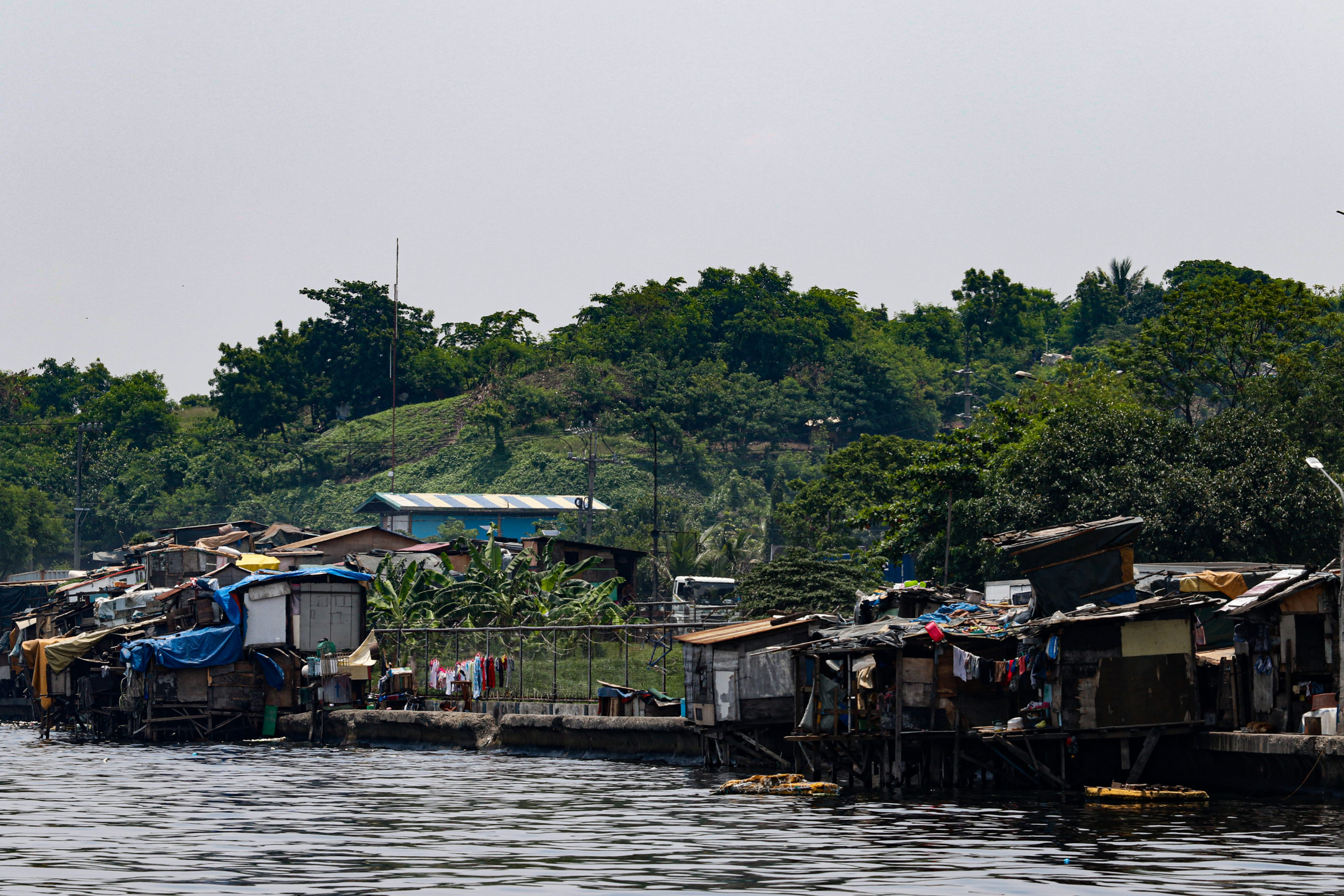
Almost out of sight from Radial Road 10 in Tondo, Manila, are rows of shanties, some of which are already on stilts and partly anchored on the seawall of Manila Bay. The green mound behind them is the infamous Smokey Mountain, which used to be a large garbage dump before it was closed in the 1990s. PHOTO BY AC DIMATATAC
“We have thought of leaving,
but where would we go?”
—Jocel Madrano, a young mother living on a stilt house over Manila Bay
Like the rest of the country, Madrano and her family have seen the fury of typhoons, which are expected to be more intense and frequent in the rapidly warming world.
But the rising sea that comes with global warming is almost an imperceptible, silent and creeping danger for the Philippines, an archipelago of 110 million people, more than half of whom live in coastal areas like them.
Scientists say sea levels rise as the warming climate melts the polar ice caps and the higher temperatures expand the oceans.
The UN Intergovernmental Panel on Climate Change reported in August this year that the average global rate of sea level rise increased from 1.9 millimeters per year between 1971 and 2006, to 3.7mm between 2006 and 2018.
“Human influence was very likely the driver of these increases,” said the report, pointing to greenhouse gas emissions from burning fossil fuels among the main culprits.
With climate change-induced sea level rise, seawater is already invading some islands in the Visayas, while seawater intrusion is a looming threat to Metro Manila, home to 13 million people. In the Manila Bay area, the sea is rising by 12.13 mm per year, about four times the global average, according to a study by the Coastal Sea Level Rise Philippines Project (CSLR-Phil), which used tide gauges and satellite measurements.
By the time Madrano’s eldest child turns 15 in 2030, the waters of Manila Bay would have risen nearly 11 centimeters.
Many settlements in the capital Manila are built close to Manila Bay and other waterways winding across the city. Graphics by: Maximillan Villanos, Elizalde Pusung
In another 20 years, coastal areas from Navotas City to Las Piñas City in Metro Manila, which stretch for about 28 kilometers, will be below the annual average flood level, according to projections by Climate Central, a nonprofit composed of scientists and journalists researching climate change. If no action is taken in the coming years—from the reduction in greenhouse gases to actual mitigation measures—more areas may be more susceptible to both rising seas and coastal flooding.
The rise in sea levels could be higher in some parts of Metro Manila, like Caloocan, Navotas, Malabon and Valenzuela, where the ground is sinking due to overextraction of groundwater, according to a study by geologists Kelvin Rodolfo and Fernando Siringan. These cities also buckle under the weight of a growing population and a construction boom.
Urbanization, whose key features are concrete structures and pavements that block water absorption by the ground, also contributes to the rising sea levels, says Rosalie Reyes, head of the CSLR-Phil project.
Initial results of the IM4 Manila Bay program, which studies the bay and its watershed, showed that road and building construction increased surface runoff, allowing large volumes of water to flow straight into the bay through rivers and canals, increasing its water load, Reyes said.
The impacts of climate change, from extreme weather events to sea level rise, will spare no one.
But communities living in precarious conditions and with low capacity to adapt will lose more, according to Ven Paolo Valenzuela, who has studied disaster risk reduction policies and climate change adaptation in the Philippines and in the Asia-Pacific.
“They have no permanence and no economic security, and as long as they do not have that, they will seek opportunities that expose themselves to risks,” he said.
After a disaster, those with no economic means just rebuild on site, re-exposing themselves to the same risks, just like Madrano’s husband, who patches up the family home with scraps of wood and tin sheets left behind by every strong storm that rips their shanty.
Around the world, poor families who remain in informal coastal settlements where they can continue earning a living will be plunged deeper into poverty after every calamity, Valenzuela said.
“They routinely go back to these places because this is where their livelihood is,” he said. “They are willing to risk themselves, to gain something today, and then risk [again] tomorrow.”
Graphics by: Maximillan Villanos, Elizalde Pusung
Across the Philippines, Filipinos grapple with the impacts of the climate crisis that turns seasonal storms into super typhoons, extends droughts and accelerates rising sea levels. Compounded by poverty, these extreme conditions trigger migration.
In Metro Manila, the narratives of indigent and informal settlers follow a common thread—leaving the hard life in their provinces to seek fortune in the big city. But most face the same challenges of poverty and displacement, albeit in an urban setting.
Years ago, Teresita Galo, 51, moved from storm-battered Samar province to work as a housekeeper in Metro Manila. At least two generations of her family now live in Navotas City.
They live in stilt houses near the mouth of Batasan and Tanza rivers that empties into Manila Bay. Unlike in Tondo, where wooden stilts support the shanties, the homes in Tanza Dos appear sturdier as the posts are made of concrete that jut out of the stagnant, garbage-strewn water above the high tide mark.
Navotas and neighboring Malabon City are low-lying areas in the northeastern part of Manila Bay.
People there live entire lifetimes often inundated by either the floods during the rainy season or the high tide that brings the sea into their homes.
Malabon adapted somewhat by pouring new layers of concrete on top of roads. The local government also advises those building new structures to raise them high above ground level, in anticipation of knee- to waist-deep floods.
Residents who have the means have raised their homes above the high water line, some transforming their first floors into basements.
Both Malabon and Navotas invested in pumping stations to prevent or minimize flooding, augmenting those set up by the Department of Public Works and Highways and the Metropolitan Manila Development Authority. The local authorities installed 59 of them in Navotas and 29 in Malabon.
With funding from the national government, Navotas is nearing the completion of a 3.7-kilometer dike to wall up its entire coastline.
While these mitigations have prevented major floods in Navotas and Malabon in recent years, these were mainly measures for the rainy season.
Sea level rise is still not explicitly incorporated in the two cities’ local climate change action plans (LCCAPs), despite the threat that it will exacerbate floods, cause coastal erosion and displace thousands of their constituents.
It is unclear whether Manila, the welcome mat for the bay’s rising water, has its own plans to respond to the same challenge. The city’s disaster risk reduction and management (DRRM) officer turned down repeated requests for an interview, saying that its LCCAP and DRRM plans have not been approved by the city council.
Under the Climate Change Act of 2009, all local governments in the country are tasked with crafting their LCCAPs, which detail how they would adapt and respond to climate change impacts. These plans should be backed by scientific studies and actual ground conditions.
The Department of the Interior and Local Government had directed all local governments to transmit their plans to the Climate Change Commission (CCC) by July.
CCC said that as of Sept. 1, it has received copies of the LCCAPs of only 702 out of 1,715 provincial, city and municipal governments across the country. In Metro Manila, only six out of its 16 cities and one municipality submitted their plans, namely the cities of Marikina, Pasig, Quezon, Caloocan, Makati and Malabon.
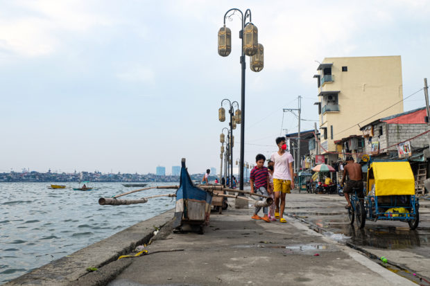
Metro Manila, home to 13 million people, already grapples with seasonal floods from typhoons. This situation, however, can be worsened by rising sea levels, which could inundate and displace its coastal communities. PHOTO BY AC DIMATATAC
The DRRM officers of Malabon and Navotas said they were aware of the threat of sea level rise, but for the moment they believe that their current responses to seasonal flooding would be able to deal with that problem.
The coastal dike, for instance, already defends Navotas from high tides and storm surges, said Vonne Villanueva, the city’s DRRM officer.
More pressing concerns, like the ongoing COVID-19 pandemic, can disrupt plans and shift funds away from climate change action, especially for an unseen and seemingly distant danger.
Malabon’s DRRM officer, Roderick Tongol, said their hazard maps show the low-lying and flood prone areas in the city, but the city government has not yet initiated its own studies to show how sea level rise could threaten its residents. Navotas does not have its own studies either.
Comprehensive studies can strain government resources since these would require not only manpower and know-how, but also funding. Villanueva said partnerships between city governments and scientific and technical experts, including those from the academic community, can help in this endeavor.
Unless there is “solid data” to support any proposed mitigation measure, it would be difficult for local leaders to muster the “political will” to act on that threat, says Tongol.
“Since the flooding situation in Malabon has improved from years ago, it’s harder to explain that [sea level rise] is happening,” he said.
For both cities, relocating communities away from coastal areas and riversides is a more immediate, encompassing response to keep people out of harm’s way.
Thousands have already been moved to government housing projects in the provinces of Rizal, Cavite and Bulacan. Others were offered in-city relocation.
In efforts to clear its waterways of informal settlers, Navotas City offered to relocate the residents both within and outside the city. Some, however, feel conflicted about leaving their homes, despite residing very close to or already over the water. PHOTO BY AC DIMATATAC
But Valenzuela, the expert on disaster risk reduction policies, cautions against relocation without socioeconomic preparation.
“The way we treat relocation, it’s just one hair shy of eviction,” he said. “When we talk about relocation and resettlement, we have to consider basic services. We have to consider why they are there in the first place.”
Like many relocation efforts across Metro Manila, these are often met with resistance. The urban poor resent being thrown to far-flung locations with little to no access to livelihood, transportation, water and electricity.
Despite their vulnerable situation, Galo and the other families in Tanza Dos have no plans to resettle in another place again.
Majority of the residents in Navotas are fishers, or make their living at its shipyards and fish port. Leaving would not only mean loss of homes, but also jobs and security.
“The sea is scary, but our livelihood is here,” said Ruel Guban, a fisherman and one of Galo’s neighbors. “If we get scared of what may happen, then our families would go hungry.”
Several residents in their community are also hesitant to move to the in-city relocation just a stone’s throw away from their shanties. The monthly rental fee of P300, they say, would be an additional burden on their families, amid the uncertainty of jobs and the unpredictability of catch from Manila Bay.
But Madrano, the young mother from Tondo, feels differently. She yearns for a house on solid ground, with concrete walls and floor, and where there is no filthy water below that her children can fall into.
“I dream of having a home of our own,” she said, “a home that I could leave behind to my children.”
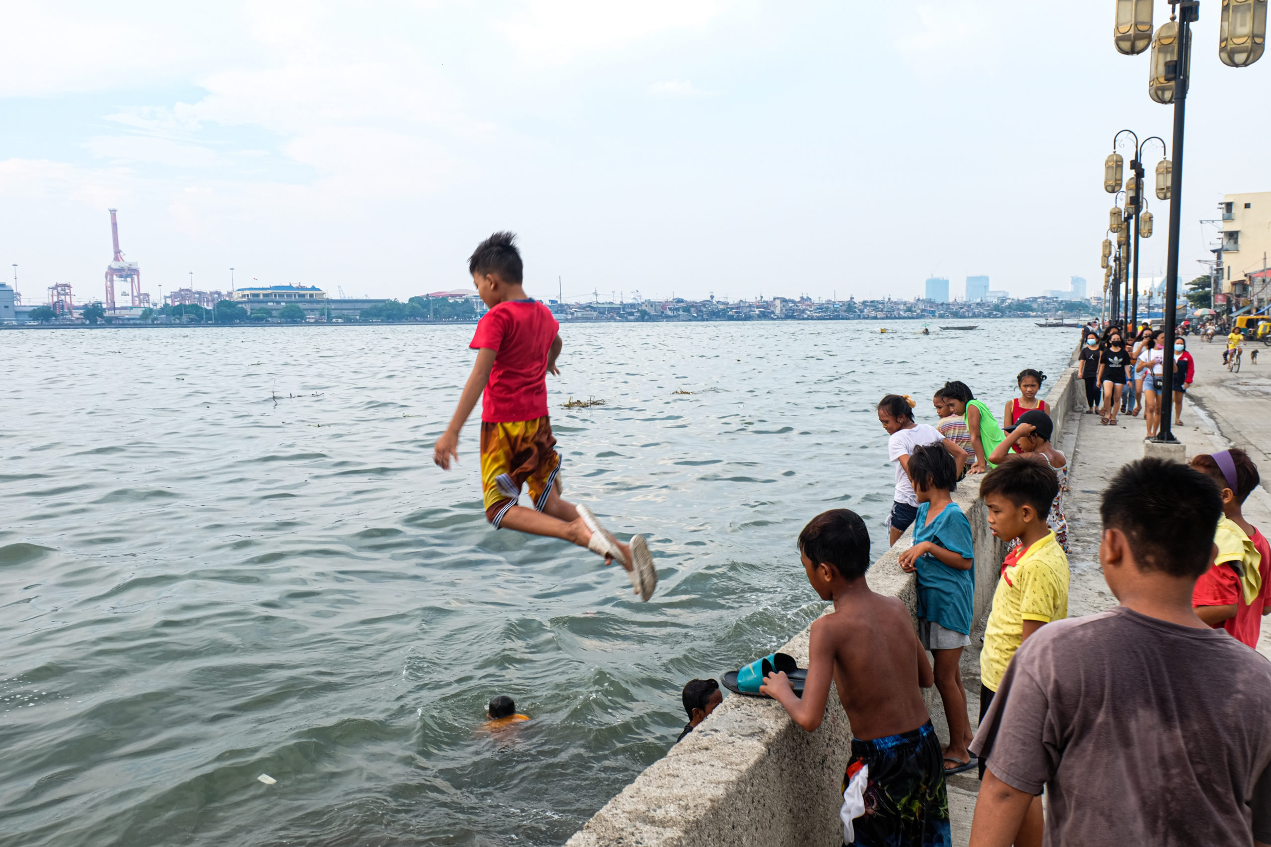
Children living near Manila Bay see no danger in living close to the sea. For many of them residing in packed communities, the water is their playground, their place for recreation. PHOTO BY AC DIMATATAC
Part 2: Long-term plans needed to protect Metro Manila’s most vulnerable from rising seas
This story was produced in collaboration with the Institute for Climate and Sustainable Cities, with the support of Internews’ Earth Journalism Network and Asian Center for Journalism.