Jolina weakens; heavy rainfall expected in NCR, other parts of Luzon under Signal No. 2
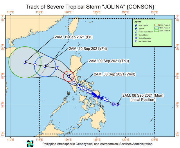
MANILA, Philippines — Typhoon Jolina has weakened to a severe tropical storm and is now moving over the Tayabas Bay-Verde Island area, while Tropical Cyclone Wind Signals (TCWS) No. 2 was raised over more areas in Luzon, the state weather service said on Wednesday.
The Philippine Atmospheric, Geophysical and Astronomical Services Administration (Pagasa), in its 5 am bulletin, said Jolina maintains a maximum sustained winds of 100 kilometer per hour (kph) near the center with gustiness of up to 150 kph.
“In the next 24 hours, heavy to intense with at times torrential rains will be experienced over Metro Manila, Romblon, Marinduque, Cavite, Laguna, Batangas, Rizal, Quezon, Camarines provinces, and Mindoro provinces,” Pagasa said.
“Moderate to heavy with at times intense rains are also likely over Aurora, Bataan, Bulacan, Nueva Ecija, Pampanga, Tarlac, Zambales, Albay, Sorsogon, northern Palawan, Aklan, Antique, Capiz, Iloilo, and Guimaras. Under these conditions, scattered to widespread flooding (including flash floods) and rain-induced landslides are highly likely,” it added.
Areas under TCWS 2 (damaging gale-force to storm-force winds are expected in the next 24 hours.)
- Metro Manila
- Northern portion of Romblon (Banton, Corcuera, Concepcion, Calatrava, San Andres, San Agustin, Romblon)
- Marinduque
- Northern and central portions of Oriental Mindoro (Bansud, Gloria, Pinamalayan, Pola, Socorro, Victoria, Puerto Galera, San Teodoro, Baco, City of Calapan, Naujan)
- Northern and central portions of Occidental Mindoro (Abra de Ilog, Paluan, Mamburao, Santa Cruz, Sablayan) including Lubang Islands,
- Central and southern portions of Quezon (Buenavista, Mulanay, San Narciso, San Francisco, San Andres, Catanauan, General Luna, Lopez, Macalelon, Sampaloc, Unisan, Pagbilao, Sariaya, Alabat, Pitogo, City of Tayabas, Padre Burgos, Lucban, Gumaca, Agdangan, Plaridel, San Antonio, Candelaria, Atimonan, Quezon, Tiaong, Mauban, Perez, Lucena City, Dolores, Real, Infanta),
- Batangas
- Cavite
- Laguna
- Rizal
- the southern portion of Bulacan (Pandi, Bulacan, Marilao, Calumpit, Norzagaray, Plaridel, Santa Maria, Balagtas, Bocaue, Bustos, City of Malolos, Angat, Obando, City of San Jose del Monte, Pulilan, City of Meycauayan, Hagonoy, Paombong, Guiguinto, San Rafael, Baliuag)
- Pampanga
- Bataan
- Zambales
- Tarlac
Areas under TCWS No. 1
Luzon
- La Union
- the southern portion of Benguet (Sablan, Tublay, Bokod, La Trinidad, Baguio City, Itogon, Tuba, Kapangan, Atok)
- the southern portion of Nueva Vizcaya (Alfonso Castaneda, Dupax del
- Norte, Dupax del Sur, Aritao, Santa Fe, Kayapa)
- the southern portion of Aurora (Baler, Maria Aurora, San Luis, Dingalan)
- Pangasinan
- Nueva Ecija
- the rest of Bulacan
- the rest of Quezon including Polillo Islands
- Camarines Norte
- the western portion of Camarines Sur (Del Gallego, Ragay, Lupi, Sipocot, Libmanan, Calabanga, Bombon, Pili, Naga City, Cabusao, Canaman, Gainza, Camaligan, Magarao, Pasacao, Pamplona, San Fernando, Milaor, Minalabac, Bula, Baao, Nabua, Balatan, Bato, Ocampo, Iriga City, Tinambac, Siruma)
- the western portion of Albay (Libon, Oas, City of Ligao, Pio Duran, Polangui)
- the northwestern portion of Masbate (Aroroy) including Burias Island
- the rest of Romblon the rest of Oriental Mindoro
- the rest of Occidental Mindoro
Visayas
Article continues after this advertisement- the northwestern portion of Antique (Caluya)
- the northern portion of Aklan (Makato, Numancia, Buruanga, Tangalan, Ibajay, Malay, Nabas)
Article continues after this advertisement
Warning: Rough sea conditions!
Jolina will bring rough to very rough sea conditions with 2.5 to 5.0 meters of waves over the seaboards of areas where TCWS #2 is in effect.
“Sea travel is risky for all types of seacrafts over these waters,” Pagasa warned.
“Mariners without the proper experience should immediately seek safe harbor.”
Moderate to rough sea condition with 1.2 to 2.8 m of waves will be experienced over the seaboards of areas where TCWS #1 is in effect, as well as the remaining seaboards of Visayas.
Jolina is set to move over the Tayabas Bay and make another landfall in the vicinity of eastern Batangas on Wednesday morning, but the possibility of landfall in the vicinity of northern Oriental Mindoro is likewise possible.
Jolina is expected to exit the Philippine Area of Responsibility on Friday morning.
gsg