


Source: Pagasa / DOST
MANILA, Philippines — Majority of the country will experience rain shower due to the effects of “habagat” or southwest monsoon enhanced by the presence of Severe Tropical Storm Fabian, said Philippine Atmospheric, Geophysical and Astronomical Services Administration (Pagasa) on Monday.

The other tropical depression spotted outside the Philippine Area of Responsibility (PAR) has also intensified into a tropical storm (international name: Cempaka) and is located 945 kilometers west of extreme northern Luzon.
Though moving away from the country, Pagasa said Cempaka is also contributing to the strengthening of the southwest monsoon.
“Kaya’t asahan ng mga kababayan natin ‘yung mga pag-ulan na dulot ng habagat mararanasan pa rin sa Ilocos Region, sa lalawigan ng Zambales at Bataan, dito sa Occidental Mindoro at sa Palawan ngayong gabi,” said Pagasa senior weather specialist Chris Perez.
(So our countrymen may expect to experience rain caused by the southwest monsoon in the Ilocos Region, in the provinces of Zambales and Bataan here in Occidental Mindoro and in Palawan tonight.)
“Magiging maulap naman [at] may mga pag-ulan at pulo-pulong pag-kidlat at pag-kulog dito sa Metro Manila, sa Cordillera Administrative Region, sa Calabarzon, sa Western Visayas, dito rin sa may bandang Cagayan, Batanes, Pampanga, Tarlac, at Bulacan ngayong gabi,” he added.
(Cloudy skies with rains, lightning and thunder will be experienced over Metro Manila, Cordillera Administrative Region, Calabarzon, Western Visayas, Cagayan, Batanes, Pampanga, Tarlac, and Bulacan tonight.)
Meanwhile, the rest of the country will experience slightly cloudy to cloudy weather with chances of scattered rain showers due to localized thunderstorms.
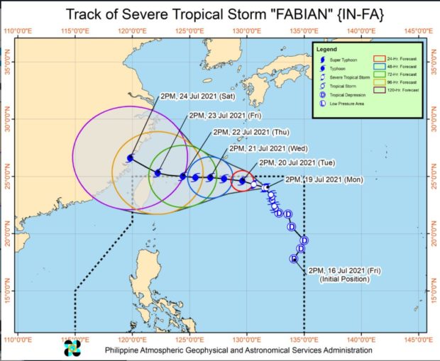
The same weather will prevail on Tuesday, according to Pagasa, as Fabian is expected to move north-northwestward and leave PAR by Thursday or Friday.
Fabian is still not expected to bring heavy rainfall in any part of the country as it continues to coast the borders of PAR.
Pagasa added that the hoisting of tropical cyclone wind signals over any land area remains less likely.
“However, any further southward shift in the orientation of the track forecast may result in the hoisting of TCWS #1 over Batanes and Babuyan Islands,” said Perez.
Forecast temperature range in key cities/areas:
- Metro Manila: 25 to 31 degrees Celsius
- Baguio City: 16 to 22 degrees Celsius
- Laoag City: 25 to 31 degrees Celsius
- Tuguegarao: 25 to 35 degrees Celsius
- Legazpi City: 25 to 32 degrees Celsius
- Puerto Princesa City: 24 to 30 degrees Celsius
- Tagaytay: 22 to 29 degrees Celsius
- Kalayaan Islands: 25 to 30 degrees Celsius
- Iloilo City: 25 to 31 degrees Celsius
- Cebu: 26 to 32 degrees Celsius
- Tacloban City: 25 to 33 degrees Celsius
- Cagayan De Oro City: 24 to 32 degrees Celsius
- Zamboanga City: 24 to 33 degrees Celsius
- Davao City: 25 to 33 degrees Celsius
No gale warning has been issued but rough seas are expected in the country’s western seaboard, while moderate to rough seas are expected in the eastern seaboard.
“Ibayong pag-iingat po sa mga kababayan nating papalaot dito lalo na ‘yung mga mangingisda at ‘yung may mga maliliit na sasakyang pandagat,” said Perez.
(We remind those who sail in these affected areas, especially fishermen and those with small vessels to be extra careful.)
RELATED STORY:
Fabian intensifies into severe tropical storm — Pagasa