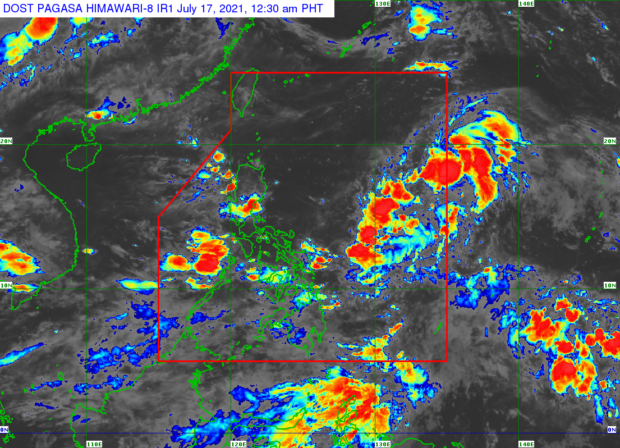
Source: Pagasa / DOST
MANILA, Philippines — Tropical depression Fabian is currently enhancing the southwest monsoon or habagat and is forecast to intensify into a tropical storm within the next hours, the Philippine Atmospheric, Geophysical and Astronomical Services Administration (Pagasa) said Saturday morning.
Based on Pagasa’s bulletin issued 5 a.m., Fabian is unlikely to bring heavy rainfall in the country throughout its forecast period. However, it enhances the southwest monsoon, which may bring monsoon rains over the Mimaropa region (Mindoro, Marinduque, Romblon, and Palawan) and the western portion of Visayas within 24 hours.
According to the state weather bureau, Fabian slightly intensified while moving toward the eastern border of the Philippine area of responsibility (PAR).
Its center was last located 1,365 kilometers east of extreme Northern Luzon. The weather disturbance was packing maximum sustained winds of 55 kilometers per hour (kph) near the center and gusts of up to 70 kph, and is now moving north-northeastward at 15 kph.
“Fabian is forecast to reach tropical storm category within 12 hours. Furthermore, this tropical cyclone will continue intensifying throughout the remainder of the forecast period and may reach typhoon category by Wednesday evening or Thursday morning,” said Pagasa.
Meanwhile, Pagasa noted that the hoisting of tropical cyclone wind signals in any part of the country remains unlikely. In the next 24 hours, the tropical depression is also less likely to cause sea conditions within coastal waters.
According to Pagasa, Fabian will remain far from the Philippine landmass throughout the forecast period.
“The tropical depression is forecast to move northward or north northwestward until tomorrow early morning. This may bring the center of Fabian outside the PAR for a brief period,” it added.
After re-entering PAR, the tropical cyclone will then move northwestward or west northwestward and may exit PAR through the northern boundary between Monday evening and Tuesday morning while moving toward the southern portion of the Ryukyu Islands.
“However, due to the uncertainty in model guidance at this portion of the track forecast, there remains a possibility that Fabian may still be inside the PAR beyond Monday,” Pagasa said.
Weather forecast
Meanwhile, Pagasa said in a separate bulletin that the southwest monsoon will bring cloudy skies with scattered rain showers and thunderstorms in Mimaropa, Bicol Region, Visayas, Zamboanga Peninsula, Zambales, Bataan, Tawi-Tawi, Sulu and Basilan.
Partly cloudy to cloudy skies with rain showers or thunderstorms may prevail in Metro Manila and the rest of the country due to the southwest monsoon or localized thunderstorms.
RELATED STORIES:
Tropical Depression Fabian maintains strength, landfall still unlikely — Pagasa | ‘Fabian’ to bring rain over West Luzon, Visayas