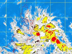
MANILA, Philippines — The low pressure area being monitored by the state weather bureau has drawn closer to the country.
In the Philippine Atmospheric, Geophysical and Astronomical Services Administration’s latest bulletin, the LPA was seen 400 kilometers east of Mindanao.
Pagasa warned (https://newsinfo.inquirer.net/145783/new-storm-brewing-off-mindanao) residents in affected areas to prepare for heavy rains in the next few days.
Meanwhile, Southern Luzon, Visayas and Mindanao will experience cloudy skies with scattered rainshowers and thunderstorms with widespread rains over Eastern Visayas and Eastern Mindanao which may trigger flashfloods and landslides . The rest of Luzon will have mostly cloudy skies with light rains.
Moderate to strong winds blowing from the East will prevail over Luzon and coming from the east to northeast over Visayas and Mindanao. The coastal waters throughout the achipelago will be moderate to rough, it added.
