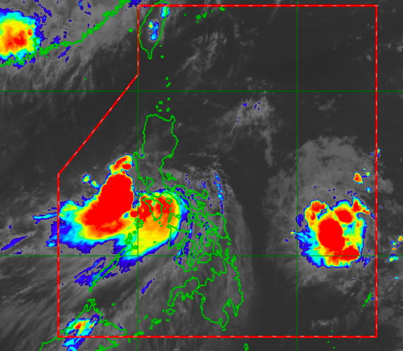
MANILA, Philippines—Tropical Storm Dante will bring moderate to heavy rainfall across much of Luzon, particularly in its western part, the Philippine Atmospheric, Geophysical, and Astronomical Services Administration (Pagasa) said on Wednesday.
Pagasa said that parts of the Ilocos Region and the western portion of Central Luzon might experience strong winds and rain showers on Thursday as Dante moves over the West Philippine Sea by the time it passes over Bataan and Zambales.
Meanwhile, areas in Bicol Region may have clearer skies, but isolated thunderstorms may occur from time to time.
Earlier, Pagasa said that Dante was last seen over the coastal waters of Calapan, Oriental Mindoro, packing maximum sustained winds of 65 kilometers per hour (kph) near the center and gustiness of up to 90 kph.
Due to this, recently high temperatures over Luzon will drop: Metro Manila would have something around 24 to 30 degrees Celsius, normally-hot Tuguegarao with 25 to 31 degrees, Laoag with 24 to 31 degrees, Baguio City with 16 to 23 degrees, Tagaytay with 21 to 28 degrees, Puerto Princesa with 25 to 32 degrees, and Legazpi with 26 to 32 degrees.
Better weather conditions may also be felt in huge parts of Visayas and Mindanao after initially feeling the effects of Tropical Storm Dante. Iloilo, Cebu, and Tacloban would have temperatures of 25 to 32 degrees Celsius, Zamboanga and Davao with 25 to 33 degrees, and Cagayan de Oro with 24 to 33 degrees.
Still, Pagasa warned areas in Visayas and Mindanao that even light and isolated thunderstorms can still cause flash floods for low-lying areas and landslides for those near mountain slopes, as mountains and river channels have received a huge amount of rainfall in the past days.
Pagasa’s observed rainfall measurement showed that most parts of Visayas and the northern and eastern section of Mindanao received high amounts of rainfall in just two days, as Dante cut across the regions by moving from east to west.
“By 8:00 p.m. ng May 31 hanggang June 1, 8:00 a.m., may naitala pong moderate na mga pag-ulan dito sa malaking bahagi ng Caraga, at sa ilang bahagi din ng Eastern Visayas, at may mga light rains naman sa may Zamboanga peninsula at sa Western Visayas,” weather specialist Ariel Rojas said.
(By 8:00 p.m. of May 31 up to June 1, 8:00 a.m., we tallied moderate rainfall in huge parts of Caraga Region, parts of Eastern Visayas, while Zamboanga peninsula and Western Visayas got light rains.)
“Samantala kahapon po, June 1 8:00 a.m. to 8:00 p.m., naitala po ang lagpas 90 millimeters na pag-ulan sa Maasin City station ng Pagasa, at nakita po natin sa social media ang mataas na mga pag-baha na na-observe dyan dahil sa malalakas na pag-ulan,” he added.
(But yesterday, June 1, from 8:00 a.m. to 8:00 p.m., we saw over 90 millimeters of rainfall in Pagasa’s Maasin City Station, and we saw over social media how communities near that area were flooded because of the strong rains.
Meanwhile, a low-pressure area (LPA) outside the Philippine area of responsibility (PAR) is still being monitored by Pagasa, although it is not expected to intensify to a tropical depression.
The LPA was last seen 1,250 kilometers east of Virac, Catanduanes, and may enter PAR on Thursday night. While not yet seen to intensify, the LPA may still bring rains in the coming days.
Pagasa advised people to continue monitoring their social media accounts for developments on Dante and other information, including about the new low-pressure area.
