‘Crising’ weakens into tropical depression after landfall; Signal No. 2 warning lifted – Pagasa
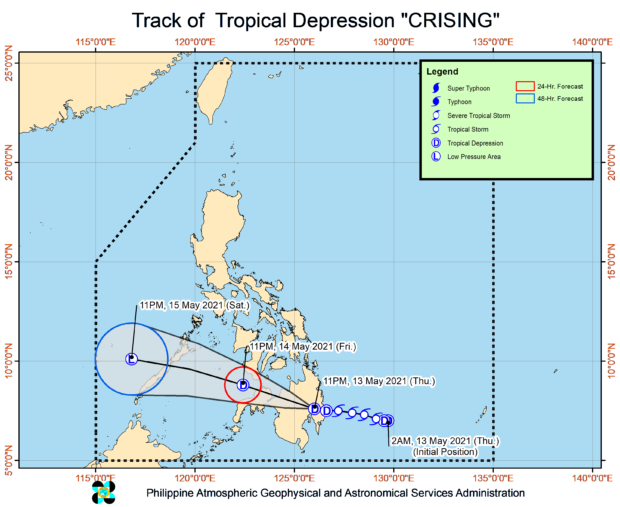
MANILA, Philippines — “Crising” has reverted to a tropical depression-category cyclone after it hit land in Mindanao, the Philippine Atmospheric, Geophysical and Astronomical Services Administration (Pagasa) said late Thursday night.
The state weather bureau said Crising made landfall around 8:20 p.m. Thursday, and was packing maximum sustained winds of 55 kilometers per hour (kph) near the center and gustiness of up to 90 kph.
By 10:00 p.m., Crising’s eye was last seen in the vicinity of New Bataan town in Davao de Oro. It is moving west at a speed of 20 kph.
As Crising weakened, all Tropical Cyclone Wind Signal No. 2 warnings have been lifted and most areas have been placed under Signal No. 1:
- southeastern portion of Negros (Dumaguete City, Valencia, Sibulan, Santa Catalina, Siaton, Zamboanguita, Dauin, Bacong)
- Siquijor
- southern portion of Surigao del Sur (Barobo, Tagbina, Hinatuan, Bislig City, Lingig)
- central and southern portions of Agusan del Sur (Esperanza, San Francisco, Talacogon, San Luis, Rosario, Bunawan, Trento, La Paz, Loreto, Veruela, Santa Josefa)
- Davao Oriental
- Davao de Oro
- Davao del Norte
- Davao City
- northern portion of Cotabato (Magpet, Arakan, Antipas, President Roxas, Matalam, Kidapawan City, Kabacan, Carmen, Banisilan, Alamada)
- northern portion of Maguindanao (Buldon, Barira, Matanog)
- Lanao del Norte
- Lanao del Sur
- Misamis Occidental
- Bukidnon
- central and western portions of Misamis Oriental (Claveria, Balingasag, Lagonglong, Jasaan, Villanueva, Tagoloan, Cagayan de Oro City, Opol, City of El Salvador, Alubijid, Laguindingan, Gitagum, Libertad, Initao, Naawan, Manticao, Lugait)
- northeastern portion of Zamboanga del Sur (Midsalip, Sominot, Dumingag, Molave, Mahayag, Josefina, Tambulig, Ramon Magsaysay, Aurora, Tukuran, Labangan)
- northeastern portion of Zamboanga del Norte (Sergio Osmeña Sr., Katipunan, Pres. Manuel A. Roxas, Jose Dalman, Manukan, Dipolog City, Polanco, Piñan, Mutia, Dapitan City, Sibutad, Rizal, La Libertad)
Pagasa said the above-mentioned areas under Signal No. 1 may feel wind gusts at a speed of 30-60 kph, which could bring very light or light damage to low-risk structures.
Article continues after this advertisementPagasa also warned that moderate to heavy rainfall may still persist until Friday night in Davao Oriental, Davao de Oro, Davao del Norte, Davao City, Cotabato, Maguindanao, Bukidnon, Lanao del Norte, Lanao del Sur, Misamis Occidental, Zamboanga del Sur, and the northern portion of Zamboanga del Norte.
Article continues after this advertisementThe weather service further said these conditions are still capable of causing flash floods and landslides, especially in high-risk areas or those living in low-lying areas or near mountain slopes.
The latest forecast track shows that Crising will continue to move west and exit Mindanao landmass by Friday night, at 50 kilometers west of Dipolog City in Zamboanga del Norte. It will then cross Palawan and by Saturday night, will be located 140 kilometers west-northwest of Puerto Princesa.
By this time, state meteorologists expect Crising to further weaken and regress to a low-pressure area. It is expected to leave the Philippine area of responsibility between Saturday night and Sunday morning.
