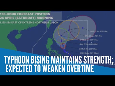
Typhoon Bising maintains strength, expected to weaken over time

MANILA, Philippines — Typhoon Bising maintained its strength as it moved north-northwestward over the Philippine Sea but is expected to “gradually weaken,” the state weather bureau said Monday.
In its 11 a.m. weather update, the Philippine Atmospheric, Geophysical, and Astronomical Services Administration (Pagasa) said Typhoon Bising will move generally northward or north-northwestward until Wednesday evening or Thursday morning.
Afterwards, the typhoon will move generally northeastward or east-northeastward away from the landmass of Luzon.
The typhoon is forecast to gradually weaken from its current intensity throughout the remainder of the forecast period.
Typhoon Bising was last tracked 235 km east-northeast of Virac, Catanduanes or 360 km east of Daet, Camarines Norte.
The typhoon is moving north-northwestward “slowly,” with maximum sustained winds of 195 kph near the center and gustiness of up to 240 kph.
Pagasa said “moderate to heavy with at times intense rains” should be expected in Bicol Region, Northern Samar, Samar, Eastern Samar, Biliran, and the northern portion of Leyte.
“Under these conditions and considering the antecedent rainfall over the aforementioned areas, flooding (including flashfloods) and rain-induced landslides are increasingly likely to occur especially in areas identified in hazard maps as highly or very highly susceptible to these hazards,” Pagasa said.
Meanwhile, Catanduanes, the eastern portion of Camarines Sur, the eastern portion of Albay and the eastern and central portions of Sorsogon in Luzon and Northern Samar, Samar, Eastern Samar, and Biliran remain under Tropical Cyclone Wind Signal No. 2
Winds of greater than 61 kph and up to 120 kph may be expected in at least 24 hours in these areas.
RELATED STORY
Signal No. 2 in 8 Luzon, Visayas areas as Typhoon Bising maintains strength