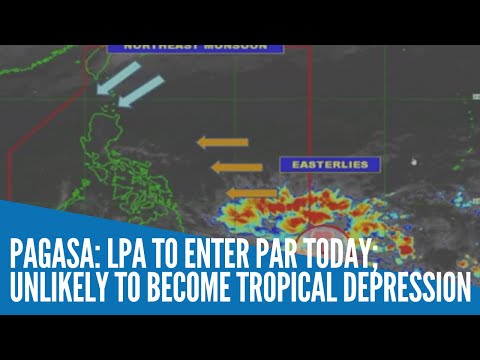
MANILA, Philippines — The low-pressure area (LPA) spotted east of Mindanao is expected to enter the Philippine area of responsibility (PAR) anytime on Tuesday, the state weather bureau said.
In its 5 a.m. live weather update, the Philippine Atmospheric, Geophysical, and Astronomical Services Administration (Pagasa) said that the LPA was last spotted at 1,130 kilometers east of Davao City.
This LPA, however, is not likely to intensify into a tropical depression, weather specialist Meno Mendoza said.
Just the same, the trough of the LPA is expected to bring cloudy skies with scattered rainshowers and thunderstorms over the Caraga and Davao Region.
Meanwhile, the northeast monsoon or amihan is affecting Northern Luzon, and will bring partly cloudy to cloudy skies with isolated light rains over Batanes and Babuyan Islands.
And Metro Manila and the rest of the country will have partly cloudy to cloudy skies with isolated rainshowers due to the easterlies, as well as localized thunderstorms.