Tropical Depression Auring slightly intensifies; seen to move towards Caraga
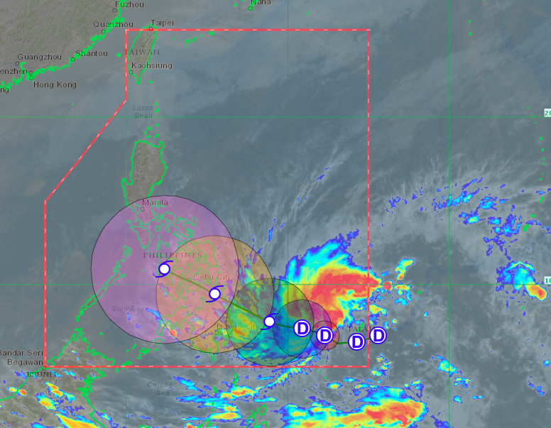
Tropical Depression Auring’s predicted path. Satellite image from Himawari IR1 via Pagasa
MANILA, Philippines — Tropical Depression Auring slightly intensified as of Wednesday afternoon, weather updates from the Philippine Atmospheric, Geophysical and Astronomical Services Administration (Pagasa) showed.
Latest reports said that Auring was last seen 700 kilometers east southeast of Hinatuan in Surigao del Sur, packing maximum sustained winds of 55 kilometers per hour (kph) near the center and gustiness of up to 70 kph.
Pagasa clarified that Auring’s has yet to affect any part of the country’s landmass directly, and rains experienced over Visayas and Mindanao are still brought by the tail end of a frontal system. However, state meteorologists assured the public that they would continue monitoring developments on the cyclone.
The latest forecast track showed that Auring’s movement slightly shifted north, as Pagasa expects it to stay over waters east of Mindanao until Saturday afternoon.
It may graze and make landfall over the northern part of the Caraga Region between Saturday night and Sunday morning before moving northwest towards Visayas’ inland seas, especially those near Central Visayas.
By Monday afternoon, it may be on the western side of Mindoro. However, Pagasa’s cone of uncertainty still shows a wide range of possible tracks, including Central Luzon and Metro Manila.
“Bahagyang umakyat ‘yong ating forecast track ni Auring o ‘yong kanyang babaybayin. Pero malaki pa rin po ang forecast error o ‘yong tinatawag nating cone of uncertainty ni Auring dahil malayo pa po ito,” weather specialist Joey Figuracion said.
(Auring’s forecast track made a slight upward nudge, which can affect its forecast track. But there is still a huge possible forecast error or the cone of uncertainty for Auring because it is still far from the country’s landmass.)
“At sa ating pagtaya ay maaari po itong mag-landfall ng Saturday ng gabi at umaga ng Sunday dy’an sa may Caraga Region,” he added.
(We expect it to make landfall between Saturday night and Sunday morning over the Caraga Region.)
Mindanao may start feeling the effects of Auring by Thursday, but it would only be because of its trough. Pagasa also reminded Metro Manila residents that a significant amount of rain may be experienced by the weekend even if Auring does not directly hit the National Capital Region.
But for Thursday, eastern parts of Luzon would still be affected by the northeast monsoon or Amihan, which would bring light rains and cold weather.
A new surge of the Amihan would mean the start of slightly lower temperatures again over Tuguegarao, which is at 21 to 30 degrees Celsius, Laoag and Metro Manila with 22 to 30 degrees, Baguio with 13 to 21 degrees, Tagaytay with 20 to 28 degrees, and Legazpi with 24 to 30 degrees.
Down south in Visayas and Mindanao, Tacloban would be a bit colder from 24 to 29 degrees Celsius compared to Iloilo and Cebu’s 25 to 30 degrees. Davao and Zamboanga would also be slightly colder from 24 to 31 degrees, while Cagayan de Oro would have something from 24 to 30 degrees.
Due to the northeast monsoon’s surge, a gale warning was hoisted over the waters over Northern Luzon, particularly Ilocos Norte, Batanes, and Cagayan including the Babuyan Islands. Fisherfolk using small boats in these areas are not allowed to set sail because gale-force winds may be experienced.
ac