


MANILA, Philippines — A big part of Luzon will still experience rain in the coming days due to combined effects of a new low-pressure area (LPA) and the tail end of a frontal system, state meteorologists said on Wednesday afternoon.
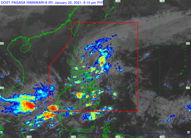
According to the Philippine Atmospheric, Geophysical, and Astronomical Services Administration (Pagasa), the LPA was last located 100 kilometers east of Baler, Aurora. The weather bureau, however, clarified that this LPA is different from the LPA spotted Tuesday, south of the Bicol Region.
Pagasa’s forecast showed that the LPA east of Aurora is not expected to become a tropical cyclone, but since it coupled with the tail end of a frontal system it may still bring moderate to heavy rains over Cagayan Valley, Aurora, and all the way up to Northern Quezon.
“Mag-ingat po sa posibleng banta ng baha doon sa mga malalapit sa ilog at saka iyong mga nasa mababang lugar, at possible din po iyong pagguho ng lupa naman sa mga mountainous areas,” weather specialist Benison Estareja said.
(Be cautious against possible flash floods especially those near rivers and those in low-lying areas, as landslides are also possible in mountainous areas.)
“Asahan din iyong mga kalat-kalat na pag-ulan, light to moderate rains sa mga susunod na oras dito po sa Metro Manila, gayundin sa Bulacan, Nueva Ecija, sa Cordillera Administrative Region, dito naman sa buong Mimaropa meron ding pag-ulan, at dito sa Bicol Region, sa natitirang bahagi pa ng Calarbarzon, at maging sa Eastern Visayas,” he added.
(Scattered light to moderate rains can also be expected in the following hours over Metro Manila, Bulacan, Nueva Ecija, the Cordillera Administrative Region, Mimaropa, Bicol Region, and the remaining parts of Calarbarzon, plus Eastern Visayas.)
The LPA is projected to move in a north-northwest pattern, which means it may traverse the provinces of Aurora, Isabela, and Cagayan until Thursday morning. It may dissipate after hitting land and mountainous areas near Cagayan Valley, Pagasa said.
Pagasa is also monitoring other cloud clusters that may become LPAs in the coming days, specifically those located northwest of Palawan and east of Bicol Region, according to Estareja.
As for other parts of Luzon and Visayas, Pagasa noted there might see generally fair weather albeit with occasional rains due to isolated thunderstorms.
Meanwhile, despite the persistent rain, temperatures are likely to increase slightly on Thursday with the temporary weakening of the northeast monsoon or amihan. Pagasa said Metro Manila’s climate will be between 24 and 30 degrees Celsius while Tuguegarao will have it at around 21 to 28 degrees Celsius; Laoag, 23 to 33 degrees Celsius; Baguio, 15 to 24 degrees Celsius; Tagaytay, 21 to 27 degrees Celsius; and Legazpi, 24 to 30 degrees Celsius.
Visayas and Mindanao, on the other hand, will experience scattered rains and yet temperatures in these regions will be around 23 to 33 degrees Celsius. Specifically, Iloilo and Cebu will feel it at 25 to 30 degrees Celsius; Tacloban, 23 to 31 degrees Celsius; Davao, 24 to 33 degrees Celsius; Zamboanga, 25 to 32 degrees Celsius; and Cagayan de Oro, 23 to 31 degrees Celsius.
Pagasa further advised fisherfolks in the northern seaboard of Luzon, western waters of Ilocos Region, and eastern coastline from Cagayan Valley to Quezon province, down to northern and eastern coasts of Camarines Norte, Camarines Sur, and Catanduanes against sailing as gale warnings are still up in these areas where waves may reach 2.8 meters to 4.5 meters high.