Pagasa: LPA starts dumping rain over Mindanao, parts of Visayas

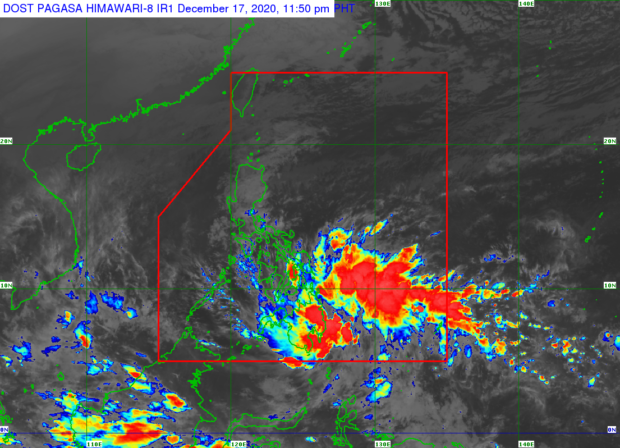
Weather satelltie image from Pagasa
MANILA, Philippines — A low-pressure area (LPA) began causing light to moderate rain over Mindanao and parts of Visayas on Thursday night, as state meteorologists maintained the possibility of it developing into a tropical depression.
Based on the Philippine Atmospheric, Geophysical and Astronomical Services Administration (Pagasa) weather updates, the LPA was 340 kilometers east southeast of Davao City, bringing rains over the eastern side of Mindanao.
Pagasa earlier predicted that the LPA would intensify into a tropical depression once it moves past Palawan en route to the West Philippine Sea. Now, it said the LPA is likely to become a tropical depression even before hitting Mindanao on Friday.
Pagasa said it is inclined to immediately raise Tropical Storm Warning Signal No. 1 in various areas of Mindanao and the Visayas once the LPA turns into a tropical depression, which by then will be named “Vicky.”
“Bagamat nasa gitna pa po ng karagatan ang sentro ng sirkulasyon, nakikita natin sa ating satellite animation na ‘yong kaulapan ng LPA ay nagdudulot na po ng pag-ulan sa malaking bahagi ng Mindanao at sa ilang bahagi po ng ka-Bisayaan,” weather specialist Ariel Rojas said.
“Posibleng paglabas niya dyan sa may Sulu Sea ay mag-develop bilang isang bagyo […] Pero hindi po natin inaalis ang posibilidad na ang LPA ay maging isang bagyo bago tumama sa kalupaan ng Mindanao,” he added.
The LPA is expected to make a northwestern nudge once it strikes Southern Mindanao, moving towards the Zamboanga peninsula and then towards Palawan, according to the state weather bureau. As it moves over the waters of the Sulu Sea, it may intensify as it leaves the Philippine area of responsibility, Pagasa added.
Pagasa warned residents that rain is expected to intensify as the LPA moves closer to land — whether it becomes a tropical cyclone or not — and cause flash floods in Mindanao.
The state weather bureau also said that sea travel may be disrupted, adding that water from Mindanao’s highlands may cause rivers to overflow, which can aggravate flooding.