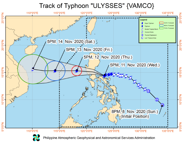
MANILA, Philippines — Quezon province has started feeling the furor of Typhoon Ulysses (international name: Vamco), as it approaches Polilio Islands, the state weather bureau said.
Strong winds and torrential rains carried by Ulysses’ eyewall and inner bands now prevail in some areas of Quezon, according to the latest severe weather bulletin of the Philippine Atmospheric, Geophysical and Astronomical Services Administration (Pagasa) released on Wednesday night.
Pagasa also said that a similar situation is now seen over the northern portion of Camarines Norte, but Aurora and Quezon will endure such conditions until Thursday morning.
Heavy to intense rains with at times torrential rainfall will also affect other areas of Camarines Norte, Camarines Sur, Metro Manila, Calabarzon, Aurora, Bulacan, Pampanga, and Bataan from Wednesday night to Thursday morning, it added.
Moderate to heavy with at times intense rains may likewise dominate the Cordillera Administrative Region, mainland Cagayan Valley, Catanduanes, Marinduque, the northern portion of Mindoro Provinces, and the rest of Central Luzon during the same period.
As of late Wednesday night, Ulysses packs maximum sustained winds of 140 kilometers per hour (kph) near the center and gustiness of up to 195 kph as it was last seen 65 kilometers north of Daet, Camarines Norte, moving at a speed of 15 kph, according to Pagasa.
It is still expected to make landfall over the Polillo Islands between 10:00 p.m. Wednesday and 12:00 a.m. Thursday and then proceed over the northern portion of mainland Quezon between 1:00 a.m. and 3:00 a.m. Thursday.
Here are the areas under Tropical Cyclone Wind Signal No. 3:
- southern portion of Quirino (Maddela, Nagtipunan)
- southern portion of Nueva Vizcaya (Alfonso Castaneda, Dupax Del Norte, Dupax Del Sur)
- Pangasinan
- Central Luzon (Nueva Ecija, Aurora, Tarlac, Zambales, Bataan, Pampanga, Bulacan)
- Metro Manila
- Calabarzon except some parts of Quezon province (Rizal, Cavite, Laguna, Batangas)
- northern and central portions of Quezon (General Nakar, Infanta, Real, Mauban, Sampaloc, Lucban, Tayabas City, Sariaya, Candelaria, Dolores, Tiaong, San Antonio, Lucena City, Pagbilao, Atimonan, Padre Burgos, Unisan, Agdangan, Gumaca, Plaridel, Pitogo, Macalelon, Lopez, General Luna, Catanauan, Buenavista, Guinayangan, Tagkawayan, Calauag, Quezon, Alabat, Perez) including Polillo Islands
- Catanduanes
- Camarines Norte
- northern portion of Camarines Sur (Del Gallego, Ragay, Lupi, Sipocot, Cabusao, Bombon, Calabanga, Tinambac, Siruma, Goa, Lagonoy, San Jose, Garchitorena, Presentacion, Caramoan)
Signal No. 2:
- the rest of Quirino
- the rest of Nueva Vizcaya
- southern portion of Benguet (Bokod, Itogon, Tublay, La Trinidad, Sablan, Baguio City, Tuba)
- southern portion of La Union (Burgos, Naguilian, Bauang, Caba, Aringay, Tubao, Pugo, Santo Tomas, Rosario, Agoo)
- the rest of Quezon
- Marinduque
- northern portion of Occidental Mindoro (Paluan, Abra de Ilog) including Lubang Island
- northern portion of Oriental Mindoro (Pola, Victoria, Naujan, Baco, Calapan City, San Teodoro, Puerto Galera)
- the rest of Camarines Sur, Albay, Sorsogon, and Burias and Ticao Islands
Signal No. 1
- Isabela
- Kalinga
- Mountain Province
- Ifugao
- the rest of Benguet
- Abra
- Ilocos Sur
- the rest of La Union
- the rest of Occidental Mindoro
- the rest of Oriental Mindoro
- Romblon
- the rest of Masbate
- Northern Samar
- northern portion of Samar (Santo Nino, Almagro, Tagapul-An, Tarangnan, Calbayog City, Santa Margarita, Gandara, Pagsanghan, San Jorge, San Jose de Buan, Matuguinao)
- northern portion of Eastern Samar (Maslog, Dolores, Oras, San Policarpo, Arteche, Jipapad)
Pagasa said areas under Signal No. 3 may sustain heavy damage especially for high-risk structures, old and dilapidated houses, and those made of light materials.
Widespread disruption of electrical power and communication services may also be expected in these areas, it added.