(Updated: 12:30 p.m., Nov. 11)
MANILA, Philippines — Tropical Cyclone Wind Signal (TCWS) No. 3 was hoisted over Metro Manila and other Luzon provinces as severe tropical storm Ulysses (international name: Vamco) intensified to a typhoon on Wednesday.
In its 11 a.m. severe weather bulletin, Philippine Atmospheric, Geophysical and Astronomical Services Administration (Pagasa) said TCWS No. 3, where winds of greater than 121 kilometers per hour (kph) up to 170 kph may be expected in at least 18 hours, is raised over:
- Metro Manila
- Southern portion of Aurora (Dipaculao, Baler, Maria Aurora, San Luis, Dingalan)
- Southern portion of Nueva Ecija (Bongabon, Gabaldon, General Tinio, Laur, Palayan City, Cabanatuan City, Santa Rosa, Peñaranda, Gapan City, San Leonardo, Jaen, San Antonio, San Isidro, Cabiao)
- Eastern portion of Pampanga (Candaba, Arayat, Santa Ana, Mexico, San Luis, San Simon, San Fernando City, Santo Tomas, Apalit, Minalin, Bacolor, Santa Rita, Guagua, Macabebe, Masantol, Sasmuan, Lubao)
- Bulacan
- Cavite
- Laguna
- Rizal
- Northern and central portions of Quezon (General Nakar, Infanta, Real, Mauban, Sampaloc, Lucban, Tayabas City, Sariaya, Candelaria, Dolores, Tiaong, San Antonio, Lucena City, Pagbilao, Atimonan, Padre Burgos, Unisan, Agdangan, Gumaca, Plaridel, Pitogo, Macalelon, Lopez, General Luna, Catanauan, Buenavista, Guinayangan, Tagkawayan, Calauag, Quezon, Alabat, Perez) including Polillo Islands
- Catanduanes
- Camarines Norte
- Northern portion of Camarines Sur (Del Gallego, Ragay, Lupi, Sipocot, Cabusao, Bombon, Calabanga, Tinambac, Siruma, Goa, Lagonoy, San Jose, Garchitorena, Presentacion, Caramoan)
Meanwhile, TCWS No. 2, where winds of greater than 61 kph and up to 120 kph may be expected in at least 24 hours, is hoisted over:
- The central and southern portions of Quirino (Maddela, Cabarroguis, Aglipay, Nagtipunan)
- Central and southern portions of Nueva Vizcaya (Kasibu, Bambang, Kayapa, Dupax Del Norte, Dupax Del Sur, Aritao, Santa Fe, Alfonso Castaneda), the southern portion of Benguet (Bokod, Itogon, Tublay, La Trinidad, Sablan, Baguio City, Tuba)
- Southern portion of La Union (Burgos, Naguilian, Bauang, Caba, Aringay, Tubao, Pugo, Santo Tomas, Rosario, Agoo)
- Pangasinan
- Zambales
- Bataan
- Tarlac
- Rest of Pampanga
- Rest of Nueva Ecija
- Rest of Aurora
- Batangas
- Rest of Quezon
- Marinduque
- Northern portion of Occidental Mindoro (Paluan, Abra de Ilog) including Lubang Island, the northern portion of Oriental Mindoro (Pola, Victoria, Naujan, Baco, Calapan City, San Teodoro, Puerto Galera)
- Rest of Camarines Sur
- Albay
- Sorsogon
- Burias and Ticao Islands
And TCWS No. 1, where winds of 30 to 60 kph may be expected in at least 36 hours, is raised over:
- Isabela
- Rest of Quirino
- Rest of Nueva Vizcaya
- Kalinga
- Mountain Province
- Ifugao
- Rest of Benguet
- Abra
- Ilocos Sur
- Rest of La Union
- Rest of Occidental Mindoro
- Rest of Oriental Mindoro
- Romblon
- Rest of Masbate
- Northern Samar
- Northern portion of Samar (Santo Nino, Almagro, Tagapul-An, Tarangnan, Calbayog City, Santa Margarita, Gandara, Pagsanghan, San Jorge, San Jose de Buan, Matuguinao)
- Northern portion of Eastern Samar (Maslog, Dolores, Oras, San Policarpo, Arteche, Jipapad)
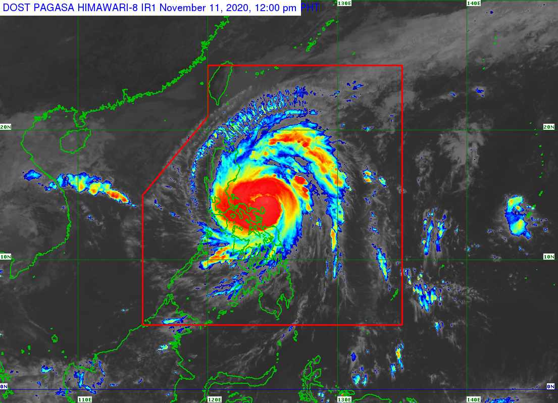
Based on Pagasa’s latest data, Ulysses intensified to a typhoon at 8 a.m. on Wednesday, and was last spotted 100 kilometers north of Virac, Catanduanes.
Ulysses also packed maximum sustained winds of 125 kph near the center, and gustiness of up to 155 kph.
The typhoon was also spotted moving west-northwestward at 20 kph.
State meteorologists said that Ulysses is forecast to move generally westward and pass over the seas north of Catanduanes between Wednesday morning and afternoon, then north of Camarines provinces between Wednesday afternoon and evening.
“Due to the orientation of the track forecast, these provinces may fall within the inner rainbands or eyewall region of this typhoon during the passage,” Pagasa said.
Pagasa added that Ulysses is forecast to make landfall over Polillo Islands and mainland Quezon between Wednesday night and early Thursday morning.
Because of Ulysses, heavy to intense with at times torrential rains are currently being experienced over Camarines Norte, Camarines Sur, and Catanduanes. Meanwhile, moderate to heavy with at times intense rains are currently hovering over Albay, Sorsogon, Quezon including Polillo Islands, and Burias and Ticao Islands.
Currently, light to moderate with at times heavy rains are being experienced over Metro Manila and the rest of Luzon and Visayas.
But between Wednesday night and early Thursday morning, heavy to intense with at times torrential rains are expected over Metro Manila, Camarines Norte, Camarines Sur, Calabarzon (Cavite, Laguna Batangas Rizal, Quezon), Aurora, Bulacan, Pampanga, and Bataan.
Moderate to heavy with at times intense rains, meanwhile, are expected over Cordillera Administrative Region, mainland Cagayan Valley, Catanduanes, Marinduque, the northern portion of Mindoro provinces, and the rest of Central Luzon between Wednesday night and early Thursday morning.
The state bureau also warned that Ulysses may cause a storm surge as high as three meters over the coastal areas of Quezon including Polillo Islands, Camarines Norte, Catanduanes, and the northern and eastern coastal areas of Camarines Sur.
Meanwhile, a storm surge as high as two meters may occur over the coastal areas of Metro Manila, La Union, Pangasinan, Isabela, Zambales, Aurora, Bataan, Pampanga, Bulacan, Cavite, Batangas, northern portions of Mindoro Provinces including Lubang Island, Marinduque, Romblon, Masbate including Ticao and Burias Islands, Albay, and Sorsogon, and the remaining coastal areas of Camarines Sur.
“These storm surges, which may be accompanied by swells and/or breaking waves near the coast, can cause life-threatening and damaging coastal inundation,” Pagasa warned.