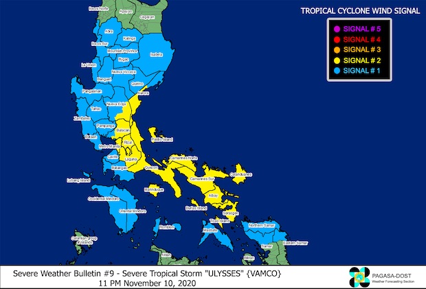
Image from PAGASA
MANILA, Philippines — Severe Tropical Storm Ulysses has slightly changed its course, heading for Southern Luzon, where it’s expected to hit Polillo Islands and Quezon province around Wednesday evening, possibly as a typhoon.
This was the latest bulletin issued on Tuesday by the Philippine Atmospheric, Geophysical and Astronomical Services Administration (Pagasa).
The previous bulletin predicted a landfall for Ulysses over the Bicol Region, which was recently ravaged by Super Typhoon Rolly.
Still, Pagasa said Ulysses would make a close approach towards Catanduanes on Wednesday morning, then near Camarines Sur and Camarines Norte by afternoon.
As of this writing, Ulysses still had maximum sustained winds of 95 kph near the center with gustiness reaching up to 115 kph.
It had moved closer to land, at around 425 km east of Daet, Camarines Norte.
It was still moving north at 30 kph.
Once it hits Quezon province, it’s expected to move through the rest of Southern Luzon, possibly directly crossing Metro Manila before going out through Manila Bay by Thursday.
It may then leave the Philippine area of responsibility by Friday.
Metro Manila was put under Tropical Cyclone Wind Signal No. 2, along with the following areas:
• the central and southern portions of Aurora — Dipaculao, Maria Aurora, Baler, San Luis, Dingalan
• the southeastern portion of Nueva Ecija — Bongabon, Laur, General Tinio, Gapan City, Peñaranda, Gabaldon
• the northern and eastern portions of Bulacan — Meycauayan City, Obando, Marilao, Bocaue, Pandi, Bustos, San Rafael, San Ildefonso, San Miguel, Angat, Santa Maria, San Jose del Monte City, Norzagaray, Doña Remedios Trinidad
• Rizal
• Laguna
• Quezon, including Polillo Islands
• Marinduque
• Bicol Region, except Masbate — Camarines Norte, Camarines Sur, Catanduanes, Albay Sorsogon, Ticao Island, and Burias Island
The following areas were put under Signal No. 1:
• Isabela
• Quirino
• Nueva Vizcaya
• Cordillera Administrative Region (except Apayao) — Kalinga, Mountain Province, Ifugao, Benguet, Abra
• Ilocos Region (except Ilocos Norte) — Ilocos Sur, La Union Pangasinan
• the rest of Aurora
• the rest of Nueva Ecija
• Tarlac
• Zambales
• Bataan
• Pampanga
• the rest of Bulacan
• Cavite
• Batangas
• Occidental Mindoro, including Lubang Island
• Oriental Mindoro
• Romblon
• the rest of Masbate
• Northern Samar
• the northern portion of Samar — Santo Nino, Almagro, Tagapul-An, Tarangnan, Calbayog City, Santa Margarita, Gandara, Pagsanghan, San Jorge, San Jose de Buan, Matuguinao
• the northern portion of Eastern Samar — Maslog, Dolores, Oras, San Policarpo, Arteche, Jipapad
Pagasa may still place some areas under Signal No. 3 since Ulysses could still intensify into a typhoon.
Strong winds would be felt over areas under wind signal warnings as Ulysses passes over them.
Those under Signal No. 2 may experience gale-force to storm-force winds, while those under Signal No. 1 may feel strong breeze to near gale conditions.
Moderate to heavy rains with at times intense rains may fall over Catanduanes, Camarines Sur, Albay, Sorsogon, and Northern Samar.
On Wednesday, light to moderate with at times heavy rains may fall over Aurora, Quezon (including Polillo Islands), Marinduque, and the rest of Bicol Region and Eastern Visayas
[atm]