Signal No. 1 raised over Bicol, Eastern Visayas towns due to Ulysses
MANILA, Philippines — Tropical Cyclone Wind Signal No. 1 was raised over some areas in the Bicol Region and Eastern Visayas last Monday night as Tropical Storm Ulysses, internationally known as Vamco, maintained its strength as it stayed over the country’s western waters.
Ulysses last located at 485 km east of Borongan City in Eastern Samar, moving slightly faster at 20 kph. Its maximum sustained winds were at 65 kph, with gusts reaching up to 80 kph, according to the Philippine Atmospheric, Geophysical and Astronomical Administration (Pagasa).
It’s expected to intensify as a severe tropical storm in the next 24 hours as it moves near the Bicol Region.
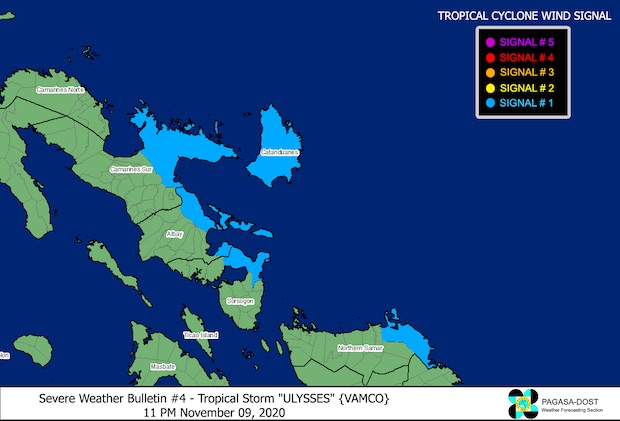
Following are the areas under Signal No. 1, where winds blowing at 30 kph to 60 kph are expected in the next 36 hours:
• the eastern portion of Camarines Sur (Siruma, Tinambac, Goa, Tigaon, Sagnay, San Jose, Lagonoy, Garchitorena, Presentacion, Caramoan)
Article continues after this advertisement• the eastern portion of Albay (Tiwi, Malinao, Tabaco City, Malilipot, Santo Domingo, Bacacay, Rapu-Rapu, Manito)
Article continues after this advertisement• Catanduanes
• the northeastern portion of Sorsogon (Sorsogon City, Gubat, Prieto Diaz)
• the eastern portion of Northern Samar (Laoang, Palapag, Mapanas, Gamay, Lapinig)
Some of these areas — particularly Camarines Sur, Albay, and Catanduanes — are still recovering from the extensive damage caused by Super Typhoon Rolly, which hit Bicol Region and Southern Luzon last Nov. 1.
Pagasa’s forecast track remained unchanged, predicting that Ulysses would move closer to the Bicol Region by Tuesday night to just 350 km east-northeast of Virac, Catanduanes.
Before making landfall over Bicol Region between Wednesday evening to Thursday morning, Ulysses may intensify as a typhoon as it moves closer to just 90 km northeast of Daet, Camarines Norte.
It can still cross over Metro Manila before leaving the Luzon landmass through the western part of Central Luzon, remaining a typhoon as it exits the Philippine area of responsibility (PAR), possibly on Friday night.
Meanwhile, its forecast track still has a wide range, which means that it may veer south or north.
On Tuesday, light to moderate rains and at times heavy rains will fall over Cagayan, including the Babuyan Islands, the eastern portion of Isabela, and Apayao due to the tail-end of a cold front.
Similar conditions are predicted over Aurora, Quezon, Bicol Region, Eastern Visayas, Caraga, and Davao Region.
But starting Wednesday, Bicol and Eastern Visayas would feel stronger rains and winds as the cyclone nears land.
As of now, gale warnings have been raised over the whole Northern Luzon seaboard and the Kalayaan Islands amid the northeast monsoon surge.
Gale warnings were also placed at the seaboards of Aurora, northern Quezon, Camarines Norte, the northern part of Camarines Sur, the eastern part of Albay, Sorsogon, Eastern Samar, and the northern and eastern portions of Catanduanes and Northern Samar.
Small boats are not allowed to set sail in these areas as waves may reach heights of 2.5 meters to 5.0 meters, which places seafarers at high risk.
[atm]