Pagasa: Rainy Monday as Ulysses nears landmass, Tonyo exits PAR
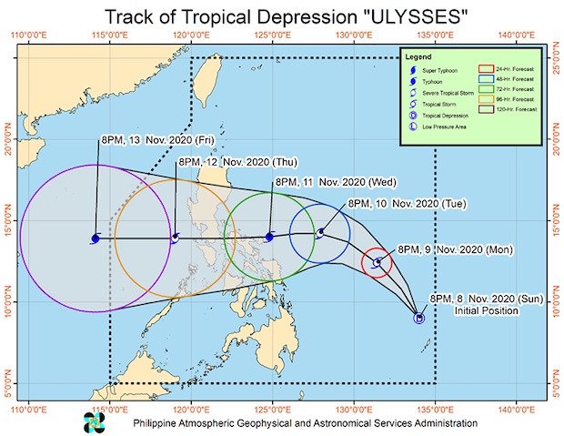
MANILA, Philippines — Tropical Depression Ulysses will bring scattered rain showers and thunderstorms to many parts pf the country, particularly the Bicol region, Eastern Visayas and Caraga region in Mindanao on Monday even as erstwhile Tropical Depression Tonyo has intensified into a tropical storm outside the Philippine Area of Responsibility (PAR).
“Today, ‘Tonyo’ is forecast to bring moderate to heavy rains over Kalayaan Islands, while the prevailing easterlies enhanced by Tonyo and Ulysses will bring moderate to heavy rains over Babuyan Islands, mainland Cagayan Valley, Cordillera Administrative Region, Ilocos Norte, Aurora, and the northern portion of Quezon including Polillo Islands,” the Philippine Atmospheric, Geophysical and Astronomical Services Administration (Pagasa) said.
“Light to moderate with at times heavy rains will be experienced over Metro Manila, Bicol Region, Eastern Visayas, and the rest of Ilocos Region, Central Luzon, and Calabarzon,” it added.
Tonyo and Ulysses’ track
Tonyo intensified into a tropical storm at 2 a.m. and exited PAR at 4 a.m., according to Pagasa’s 5 a.m. severe weather bulletin.
Article continues after this advertisementPagasa reported that the center of Tonyo was last spotted 710 kilometers west of Calapan City, Oriental Mindoro, while Ulysses was last spotted 800 km east of Surigao City, Surigao Del Norte.
Article continues after this advertisementPagasa said Ulysses has maximum sustained winds of 45 kilometers per hour near the center and gustiness of up to 55 kph. It is moving northwest at 15 kph.
Flood, landslide warnings
No tropical cyclone wind signal is in effect in any part of the country, but Pagasa warned that flash floods and rain-induced landslides are possible.
Gale-force winds are expected in Batanes, Babuyan Islands, Ilocos Norte, Apayao, and the northern portion of mainland Cagayan due to the northeast monsoon enhanced by Tonyo, according to Pagasa.
RELATED STORIES:
TD Ulysses may become a typhoon before possible Bicol landfall Wednesday
LPA first spotted east of Mindanao now a tropical depression named Ulysses

