Pagasa: Center of severe tropical storm Siony crosses Misanga Island in Batanes
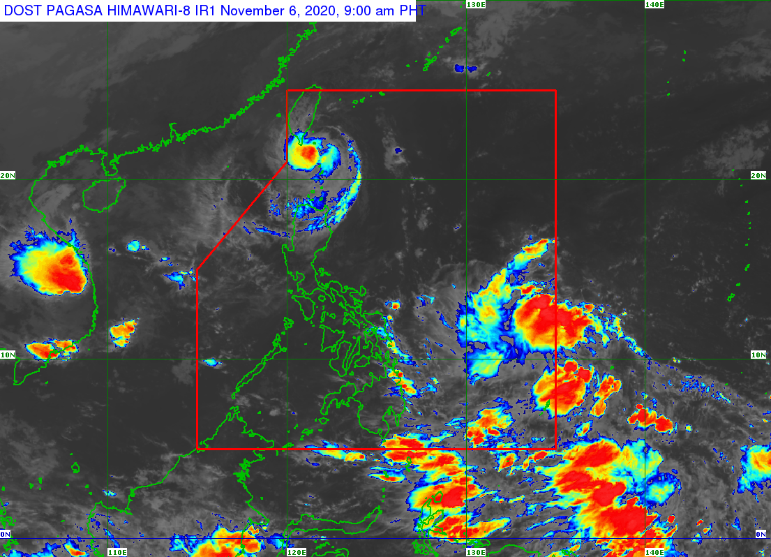
MANILA, Philippines — The center of severe tropical storm Siony crossed the island of Misanga in Itbayat, Batanes at around 7:50 a.m. Friday, according to the Philippine Atmospheric, Geophysical and Astronomical Services Administration (Pagasa).
“The center of Siony crossed the island of Misanga in Itbayat, Batanes at around 7:50 a.m. today. On the forecast track, this storm will continue moving westward to west-northwestward and pass over the sea off the southern coast of Taiwan within 12 hours,” Pagasa said in its severe weather bulletin issued at 8 a.m.
At 7 a.m., the center of the severe tropical storm was spotted 30 kilometers east-northeast of Itbayat, Batanes. It is moving westward at 20 kilometers per hour and has maximum sustained winds of 95 kph near the center and gustiness of up to 115 kph.
Siony is forecast to exit the Philippine Area of Responsibility (PAR) this Friday night. Afterward, it will turn southwestward Saturday morning over the sea to the southwest of Taiwan and move over the West Philippine Sea towards the Paracel Islands area, according to Pagasa.
The weather disturbance is forecast to either maintain its current strength or slightly intensify to 100 kph within the next 24 hours.
Article continues after this advertisementBeyond this 24-hour period, the storm is forecast to significantly weaken due to increasingly unfavorable conditions associated with a surge of the northeasterlies over the West Philippine Sea. It may be downgraded to a low-pressure area on Monday.
Article continues after this advertisementTropical Cyclone Wind Signal No. 2 remains raised in Batanes and Babuyan Islands based on the latest severe weather bulletin from Pagasa.
Meanwhile, TCWS No. 1 is raised in the following areas in Luzon:
– northern portion of mainland Cagayan (Santa Ana, Gonzaga, Lal-Lo, Allacapan, Santa Teresita, Buguey, Camalaniugan, Aparri, Ballesteros, Abulug, Pamplona, Sanchez-Mira, Claveria, Santa Praxedes)
– northern portion of Apayao (Santa Marcela, Luna, Calanasan)
– northern portion of Ilocos Norte (Adams, Pagudpud, Bangui, Dumalneg, Burgos, Vintar, Pasuquin, Bacarra)
According to the weather bureau, areas under TCWS No. 2 are currently experiencing “damaging gale-to-storm-force winds,” while those under TCWS No.1 are currently experiencing “strong breeze to near gale conditions.”
“Today, the passage of “SIONY” will bring moderate to heavy rains over areas under TCWS #2 and light to moderate with at times heavy rains over areas under TCWS #1,” Pagasa added.
Pagasa warned that flooding and rain-induced landslides may occur during heavy or prolonged rainfall especially in areas identified as highly or very highly susceptible to these hazards.
Meanwhile, the low-pressure area (LPA) outside PAR was last spotted 1,200 km east of Mindanao.
Pagasa said the LPA is forecast to move generally west-northwestward or northwestward and may enter PAR this Friday afternoon or evening.
Currently, the LPA is heading towards the direction of Eastern Visayas and may likely reach the area Saturday afternoon or evening.
Pagasa said this weather disturbance may develop into a tropical depression within the next 48 hours and will be given the local name “Tonyo.”
RELATED STORIES
Siony may either make landfall or move near extreme Northern Luzon
Expect a rainy Friday due to TS Siony, ITCZ – Pagasa