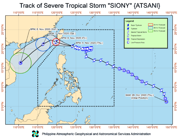
Source: Pagasa / DOST
MANILA, Philippines — Severe Tropical Storm Siony is expected to cross over the Batanes Group of Islands within the next six hours, the Philippine Atmospheric, Geophysical and Astronomical Services Administration (Pagasa) said on Thursday night.
According to Pagasa’s severe weather bulletin as of 11:00 p.m., Siony was last seen 170 kilometers east of Basco, Batanes, and is still moving west northwestward at a speed of 20 kilometers per hour.
It was able to maintain its strength, still with maximum sustained winds of 100 kph near the center, and gusts of up to 125 kph.
Pagasa is still keeping the possibility of Siony making landfall open; if not, it would graze the extreme northern Luzon islands. After which, it is expected to exit the Philippine area of responsibility by Friday night.
State meteorologists also said there is still a possibility that Siony intensifies as a typhoon, but they also expect it to weaken afterwards as cold winds from the northeasterly surface windflow would make conditions unfavorable for storms.
As of now, Tropical Cyclone Wind Signal No. 2 is still raised over Batanes and the Babuyan Islands, which means that wind speeds of 61 kph to 120 kph may be felt in the next 24 hours.
Signal No. 1 meanwhile persists in the following areas:
- Cagayan (Santa Ana, Gonzaga, Lal-Lo, Allacapan, Santa Teresita, Buguey, Camalaniugan, Aparri, Ballesteros, Abulug, Pamplona, Sanchez-Mira, Claveria, Santa Praxedes)
- northern portion of Apayao (Santa Marcela, Luna, Calanasan)
- northern portion of Ilocos Norte (Adams, Pagudpud, Bangui, Dumalneg, Burgos, Vintar, Pasuquin, Bacarra)
Areas under Signal No. 1 and 2 will experience light to moderate rains with at times heavy showers as Siony nears these areas.
Siony’s trough and the intertropical convergence zone (ITCZ) are also seen to bring scattered light to moderate rains, with at times heavy shower over a huge part of Central Luzon, Calabarzon, Mimaropa,Bicol Region which was recently devastated by Super Typhoon Rolly, as well as portions of Visayas and Mindanao.
Pagasa advised residents in the above-mentioned areas to stay tuned for updates from the weather bureau, and to coordinate with local government agencies especially those who have endured the past weather disturbance as there is a higher risk of landslides in these areas.