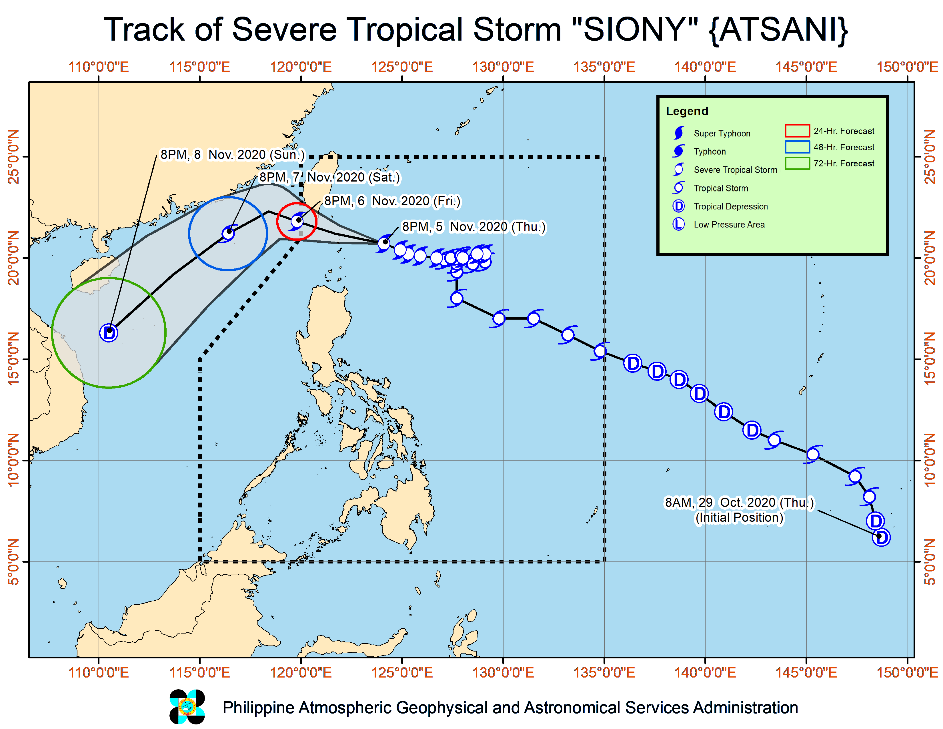
Disaster response teams were sent on Thursday to northern Luzon as severe Tropical Storm “Siony” (international name: Atsani) approached Batanes province and Babuyan Islands.
Maj. Gen. Arnulfo Marcelo Burgos Jr., commander of the Army’s Northern Luzon Command, said the military had mobilized soldiers in the Ilocos, Cagayan Valley and Cordillera regions to help in possible evacuations and relief operations.
Siony slightly intensified on Thursday afternoon, carrying winds of 100 kilometers per hour near the center and gusts of up to 125 kph, according to the Philippine Atmospheric, Geophysical and Astronomical Services Administration (Pagasa).
After slowing down earlier this week, it began to move westward, heading toward Luzon Strait, and may reach a peak intensity of 120 kph by Friday morning as it passes over or near the vicinity of Batanes or Babuyan Islands, where it could be categorized as a typhoon, Pagasa said.
Warning signals
Batanes and the Babuyan Islands was placed under Storm Signal No. 2 on Thursday in anticipation of the landfall or close approach of Siony on Friday.
Pagasa raised Storm Signal No. 1 over several other areas in the northern areas of Cagayan, Apayao and Ilocos Norte provinces.
Residents under storm warnings should brace for strong wind to near gale conditions as Siony moves closer to land, Pagasa said.
Its trough, or extension, may also bring scattered light to moderate, with at times heavy, rain showers over most parts of Central Luzon, southern Luzon, Bicol region, Visayas and Mindanao.
More rescue groups
Batanes Gov. Marilou Cayco said the provincial government had prepared heavy equipment, food packs and nonfood items, and mobilized more local rescue groups.
She asked residents to secure their houses and put wind shutters in anticipation of strong winds.
In Itbayan town, additional rescue groups were on standby in danger zones, according to Nilda Salengua Garcia, municipal disaster risk reduction and management officer.
As of 4 p.m. on Thursday, Siony’s center was estimated at 340 km east of Basco town, Batanes, moving at 20 kph. Pagasa said the storm might leave Philippine territory on Friday afternoon and gradually weaken after its exit toward the West Philippine Sea.
The weather service is also monitoring another low pressure area east of the Visayas that remained outside of the country’s territory.
Forecasters said it might enter Philippine territory by Friday afternoon and evening, and intensify into a tropical depression by the weekend. It was seen moving northwestward, heading toward Eastern Visayas and the eastern part of southern Luzon.