
Photo from Pagasa Facebook page
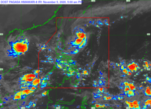
MANILA, Philippines — Tropical Cyclone Wind Signal (TCWS) No. 2 was raised over Batanes and the eastern part of the Babuyan Islands (Balintang Island, Didicas Island and Camiguin Islands including their adjoining islets) as Severe Tropical Storm Siony moved west-southwest toward the Luzon Strait on Thursday morning, state meteorologists said.
Pagasa said winds from 61 kph to 120 kph will be experienced in affected areas.
In its severe weather bulletin issued at 5 a.m., the Philippine Atmospheric, Geophysical, and Astronomical Services Administration (Pagasa) said Siony was last spotted at 595 kilometers (kms) east of Basco, Batanes at 4 a.m.
The weather disturbance is packing maximum sustained winds of 95 kilometers per hour (kph) near the center and gustiness of up to 115 kph, while moving west southwest at 10 kph.
“‘SIONY’ is forecast to reach typhoon category with a peak intensity of 120 km/h by tomorrow morning as it passes near or over the Batanes-Babuyan Islands area. After exiting the PAR, ‘SIONY’ will gradually weaken due to increasingly unfavorable conditions over the West Philippine Sea associated with a northeasterly surge,” the state weather bureau said.
TCWS Number 1 is up over the rest of Babuyan Islands, northern portion of mainland Cagayan (Santa Ana, Gonzaga, Lal-Lo, Allacapan, Santa Teresita, Buguey, Camalaniugan, Aparri, Ballesteros, Abulug, Pamplona, Sanchez-Mira, Claveria, Santa Praxedes), northern portion of Apayao (Santa Marcela, Luna, Calanasan) the northern portion of Ilocos Norte (Adams, Pagudpud, Bangui, Dumalneg, Burgos, Vintar, Pasuquin, Bacarra).