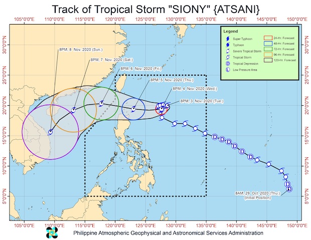
MANILA, Philippines — Tropical Storm Siony, internationally known as Atsani, started to intensify on Tuesday night as it hovered over the Philippine Sea, giving rise to the possibility that it may make landfall as a typhoon, according to the latest bulleting of the Philippine Atmospheric, Geophysical and Astronomical Services Administration (Pagasa).
Siony was packing maximum sustained winds of 85 kph with a gustiness reaching up to 105 kph.
Tropical Cyclone Wind Signal No. 1 may be raised over provinces in Cagayan Valley on Wednesday, Pagasa said.
The peak intensity of the storm may reach 100 kph to 110 kph before it nears extreme Northern Luzon.
Siony was last spotted 665 km east of Basco, Batanes, and had started moving slower northward at 10 kph.
For the next 24 hours, it would make a looping turn and eventually move westward.
This means that it would spend more time above water, allowing it further intensify.
After looping, it may move near Batanes or the Babuyan Group of Islands, possibly making landfall between Thursday night and Friday morning.
At the moment, however, Pagasa gave the storm a wide cone of probability, meaning that there was still a chance of it moving north, towards the southern tip of Taiwan, or moving south toward the northern portions of Ilocos Norte and Cagayan.
It may leave the Philippine area of responsibility by Friday afternoon or evening.
As of this writing, Siony still had no direct effect on the country’s weather, but it was seen to intensify the northeasterly surface wind flow, bringing strong winds over Northern Luzon.
Pagasa maintained gale warnings over the whole northern seaboards of Luzon and over the waters of the Ilocos Region, Cagayan, and Isabela. The waters in those areas may vary from rough to very rough — in which case, small boats would not be allowed to set sail there.
[atm]