Rolly nears PAR western border but will intensify northeasterlies with Siony
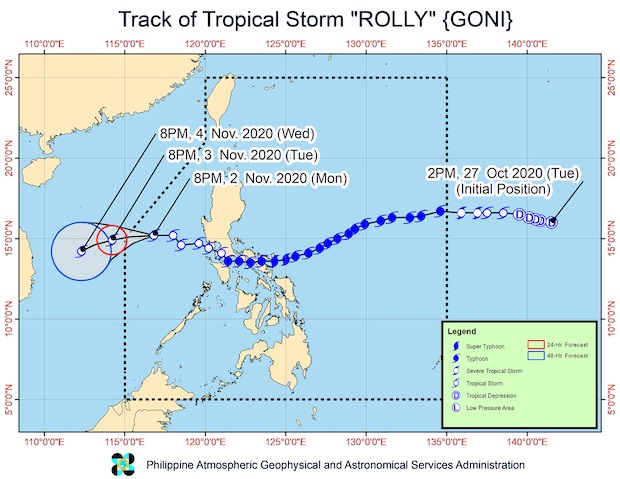
MANILA, Philippines — Tropical Storm Rolly came closer to the western border of the Philippine area of responsibility on Monday night, according to the latest bulletin Philippine Atmospheric, Geophysical and Astronomical Services (Pagasa).
Rolly was located at 365 kilometers west of Iba town in Zambales, moving west at a speed of 20 kilometers per hour (kph). While it was still packing maximum sustained winds of 65 kph with a gust reaching up 80 kph, it was expected to weaken as a tropical depression over the West Philippine Sea.
Rolly no longer had a direct effect in the country, but it would combine with Tropical Storm Siony to intensify the northeasterly surface wind, which was expected to bring strong winds over Northern Luzon.
“The northeasterlies enhanced by Tropical Storms Rolly and Siony will bring strong to near gale conditions with higher gusts over Batanes, Babuyan Islands, and the northern portions of Cagayan and Ilocos Norte,” Pagasa said.
This would cause rough to very rough seas over the entire seaboards of Northern Luzon and the western seaboard of Central Luzon, prompting Pagasa to issue a gale warning.
Article continues after this advertisementAccording to earlier forecasts, Siony was moving erratically. Pagasa would keep a close eye on it as its cone of probability was wide, meaning it had a wide range of possible track — extending from extreme Northern Luzon down to Central Luzon.
Article continues after this advertisementSiony is expected to stay almost stationary — moving north then shifting to the east by Tuesday, turning south on Wednesday, and completing a loop by moving southeast before Thursday.
However, from there, the tropical storm may lurk north toward the extreme Northern Luzon, or as far down south toward Central Luzon.
As of Monday afternoon, Siony had maximum sustained winds of 65 kph with a gustiness reaching up to 80 kph.
“The movement of Tropical Storm Siony would be erratic. It will stay in the middle of the Philippine Sea for the next two days and then it may possibly make a loop due to two high pressure areas pushing it away,” weather specialist Ariel Rojas said earlier in Filipino.
[atm]