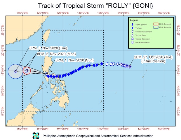
MANILA, Philippines — Tropical Storm Rolly further weakened early on Monday as it continued to move over the West Philippine Sea off the coast of Bataan, according to the Philippine Atmospheric, Geophysical, and Astronomical Services Administration (Pagasa).
According to the 2 a.m. bulletin of Pagasa, Rolly was located 155 kilometers west of Sangley Point in Cavite or 95 kilometers west southwest of Subic Bay.
It had maximum sustained winds of 75 kph near the center with a gustiness reaching up to 90 kph as it moved west-northwest at 20 kph.
Storm signals were taken down except for the following areas still under Tropical Cyclone Wind Signal No. 1:
• the northwestern portion of Occidental Mindoro (Paluan, Mamburao, Abra de Ilog) including Lubang Island
• the western portion of Batangas (Tingloy, Mabini, Bauan, San Luis, Taal, Agoncillo, San Nicolas, Santa Teresita, Talisay, Laurel, Lemery, Calaca, Balayan, Calatagan, Tuy, Lian, Nasugbu)
• the extreme western portion of Laguna (San Pedro City, Biñan City)
• Cavite
• Metro Manila
• the western portion of Bulacan (San Jose del Monte City, Santa Maria, Pandi, Bustos, Baliuag, Marilao, Meycauayan City, Obando, Bocaue, Bulacan, Balagtas, Guiguinto, Pulilan, Plaridel, Malolos City, Paombong, Hagonoy, Calumpit)
• the western portion of Pampanga (San Luis, Mexico, Masantol, Sasmuan, Floridablanca, Lubao, Porac, Guagua, Santa Rita, Bacolor, Angeles City, Santo Tomas, San Fernando City, San Simon, Macabebe, Minalin, Apalit)
• Bataan
• the southern portion of Zambales (San Marcelino, San Felipe, San Narciso, San Antonio, Castillejos, Subic, Olongapo City)
Rolly is expected to exit the Philippine area of responsibility (PAR) on Tuesday morning.
According to Pagasa, it was unlikely for Rolly to remain as a tropical storm and will most likely weaken into a low pressure area.
[atm]