
Image from Pagasa
MANILA, Philippines — Though it has slightly weakened on Sunday evening, Tropical Storm Siony may still intensify to severe tropical storm category on Tuesday, according to the Philippine Atmospheric, Geophysical, and Astronomical Services Administration (Pagasa).
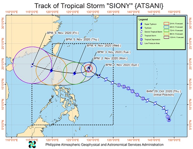
In its 11 p.m. bulletin on Sunday, the state weather bureau said Siony was located 990 kilometers east of Northern Luzon as of 10 p.m.
It had maximum sustained winds of 65 kph near the center and gustiness of up to 80 kph as it moved west-northwest at 30 kph.
According to Pagasa, it would keep that movement before it slows down, almost becoming stationary, on Monday evening until Tuesday evening. Then it will continue moving west-southwest or west toward extreme Northern Luzon.
“Due to the projected erratic movement of this system in the next 48 hours, there is a high degree of uncertainty in the forecast track,” Pagasa added.
No tropical cyclone wind signals have been raised yet for Siony, but Pagasa said it might intensify to a severe tropical storm during the period when it would be almost stationary on Tuesday.
“‘SIONY’ remains less likely to directly affect the weather and coastal water conditions in the country over the next 2 to 3 days,” Pagasa said. “However, the public and disaster managers, especially those situated in Northern Luzon, are advised to continue monitoring for updates on this tropical cyclone.”
Tropical Storm Siony entered the Philippine area of responsibility (PAR) as Typhoon Rolly ravaged several provinces in the country.
[atm]