

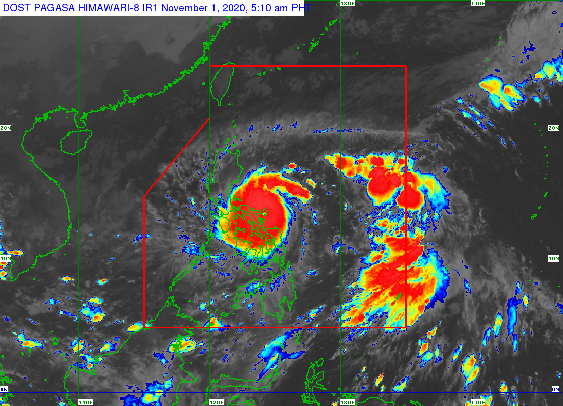
MANILA, Philippines – Super Typhoon Rolly (international name: Goni) made landfall in Bato, Catanduanes Sunday morning and brought “catastrophic violent winds and intense to torrential rainfall” to the area, the state weather bureau reported.
The Philippine Atmospheric, Geophysical and Astronomical Services Administration (Pagasa), said in its 5 a.m. severe weather bulletin that Super Typhoon Rolly slammed the vicinity of the Catanduanes municipality at 4:50 a.m., packing maximum sustained winds of 225 kilometers per hour (kph) near the center and gustiness of up to 280 kph . while moving west southwest at 25 kph.
“After traversing the southern portion of Catanduanes, the center of the typhoon will cross Lagonoy Gulf and make landfall over the southern portion of Camarines Sur or the northern portion of Albay this morning.,” Pagasa saod.
“Afterwards, the center will cross the Camarines Provinces before heading towards Calabarzon this afternoon. “Rolly” is forecast to exit the mainland Luzon landmass and emerge over the Philippine Sea tomorrow early morning,” added Pagasa.
Signal Number 5!
Tropical Cyclone Wind Signal number 5 is still up over Catanduanes, Albay, and the eastern portion of Camarines Sur (Caramoan, Presentacion, Garchitorena, Lagonoy, Tinambac, Calabanga, Siruma, Tigaon, Bombon, Magarao, Camaligan, Gainza, Canaman, Milaor, Naga City, Minalabac, Balatan, Bula, Pili, Ocampo, Goa, San Jose, Sagnay, Buhi, Iriga City, Baao, Nabua, Bato)
Pagasa warned that very strong winds of more than 220 kph may be expected in the affected areas for at least 12 hours.
Pagasa likewise warmed of possible storm surges, flash floods and landslides and stressed that low-lying and coastal areas must be cleared.
Rough seas
The weather bureau warned operators and crew of vessels not to venture out to sea due to rough sea conditions spawned by the super typhoon.
“Today, rough to phenomenal seas (2.5 to 16.0 m) will be experienced over the seaboard of areas where TCWS is in effect and rough to very rough seas (2.5 to 5.0 m) over the remaining seaboards of Northern Luzon and the eastern seaboards of Eastern Visayas (that are not under TCWS) and Caraga. Sea travel is risky for all types of seacrafts over these waters, especially those under TCWS,” warned Pagasa.
Areas under TCWS No. 4
(Winds of greater than 171 km/h up to 220 km/h may be expected for at least 12 hours.)
Camarines Norte
rest of Camarines Sur,
northern portion of Sorsogon (Donsol, Pilar, Castilla, Sorsogon City, Prieto Diaz, Gubat, Barcelona, Juban, Casiguran, Magallanes), Burias Island, the central and southern portions of Quezon (Atimonan, Padre Burgos, Agdangan, Plaridel, Unisan, Gumaca, Pitogo, Macalelon, Catanauan, General Luna, Mulanay, San Francisco, San Andres, San Narciso, Buenavista, Lopez, Guinayangan, Tagkawayan, Calauag, Quezon, Alabat, Perez), Marinduque, and the northern portion of Romblon (Concepcion, Corcuera, Banton)
Areas under TCWS No. 3
(Winds of greater than 121 km/h up to 170 km/h may be expected for at least 18 hours.)
rest of Sorsogon
northern portion of Masbate (Mobo, Masbate City, Milagros, Uson, Baleno, Aroroy, Mandaon) including Ticao Island
rest of Quezon including Polillo Island
Laguna
Batangas
Cavite
Rizal
Metro Manila
Bulacan
Pampanga
Bataan
southern portion of Zambales (San Marcelino, San Felipe, Olongapo City, Subic, Castillejos, San Antonio, San Narciso, Botolan, Cabangan)
central portion of Romblon (Calatrava, San Andres, San Agustin, Romblon, Magdiwang, San Fernando, Cajidiocan)
northern portion of Occidental Mindoro (Sablayan, Mamburao, Santa Cruz, Abra de Ilog, Paluan) including Lubang Island
northern portion of Oriental Mindoro (Bongabong, Gloria, Bansud, Pinamalayan, Socorro, Pola, Victoria, Naujan, Calapan City, Baco, San Teodoro, Puerto Galera)
Northern Samar
Areas under TCWS No. 2
(Winds of greater than 61 km/h and up to 120 km/h may be expected for at least 24 hours.)
Aurora
Nueva Vizcaya
Quirino
Benguet
La Union
Pangasinan
rest of Zambales
Tarlac
Nueva Ecija
rest of Oriental Mindoro
rest of Occidental Mindoro
rest of Romblon
rest of Masbate
northern portion of Samar (Catbalogan City, Jiabong, Motiong, Paranas, Hinabangan, San Sebastian, Tarangnan, Pagsanghan, San Jorge, San Jose de Buan, Matuguinao, Gandara, Santa Margarita, Calbayog City, Santo Nino, Almagro, Tagapul-An),
northern portion of Eastern Samar (San Julian, Sulat, Taft, Can-Avid, Dolores, Maslog, Oras, San Policarpo, Arteche, Jipapad),
extreme northern portion of Antique (Pandan, Libertad, Caluya)
northwestern portion of Aklan (Buruanga, Malay, Nabas, Ibajay)
Areas under TCWs No. 1
(Winds of 30-60 km/h may be expected for at least 36 hours or intermittent rains may be expected within 36 hours.)
Mainland Cagayan
Isabela
Apayao
Kalinga
Mountain Province
Ifugao
Abra
Ilocos Norte
Ilocos Sur
Calamian Islands
The rest of the northern portion of Antique (Sebaste, Culasi, Tibiao, Barbaza, Laua-An)
rest of Aklan
Capiz
northern portion of Iloilo (Lemery, Sara, Concepcion, San Dionisio, Batad, Estancia, Balasan, Carles),
northern portion of Cebu (San Remigio, Bogo City, Medellin, Daanbantayan) including Bantayan Islands
Biliran
rest of Samar
rest of Eastern Samar
northern portion of Leyte (San Isidro, Tabango, Villaba, Matag-Ob, Palompon, Ormoc City, Pastrana, Palo, Calubian, Leyte, Kananga, Capoocan, Carigara, Jaro, Tunga, Barugo, Alangalang, Santa Fe, Tacloban City, Babatngon, San Miguel)