
Image from PAGASA
MANILA, Philippines — Typhoon Rolly (international name: Goni), the strongest typhoon in the world so far in 2020, intensified further to a super typhoon early Sunday, according to the Philippine Atmospheric, Geophysical and Astronomical Services Administration (Pagasa).
Because of this PAGASA warned that Tropical Cyclone Wind Signal (TCWS) No. 5 will be raised over Catanduanes, Eastern Camarines Sur, and Albay.
“Catastrophic wind damage is expected,” Pagasa said in a tweet.
Under Pagasa’s public storm warning signal, TCWS No. 5 means that winds of more than 220 kilometers per hour (kph) is expected in at least 12 hours, and a storm surge of more than 3 meters is possible at coastal areas.
Currently, Catanduanes, Camarines Sur, and the northern portion of Albay and the eastern portion of Quezon are under TCWS No. 4.
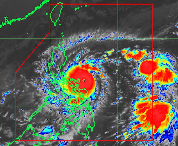
At 2:00 AM today, Typhoon #RollyPH intensified into a Super Typhoon. TCWS #5 will be raised over Catanduanes, Eastern Camarines Sur, and Albay. Catastrophic wind damage is expected. pic.twitter.com/pj2uwT5hZe
— PAGASA-DOST (@dost_pagasa) October 31, 2020
Meanwhile, Signal No. 3 is raised over:
the rest of Albay
Burias and Ticao Islands
Sorsogon
the rest of Quezon including Polillo Islands
Laguna
Rizal
Cavite
Batangas
Metro Manila
the southern portion of Bulacan (Norzagaray, Santa Maria, Balagtas, Bulacan, San Jose del Monte City, Bocaue, Marilao, Meycauayan City, Obando)
Marinduque
the northern portion of Occidental Mindoro (Abra de Ilog)
the northern portion of Oriental Mindoro (Gloria, Pinamalayan, Socorro, Pola, Victoria, Naujan, Calapan City, Baco, San Teodoro, Puerto Galera)
the northern portion of Romblon (Concepcion, Banton, Corcuera)
Northern Samar
Signal No. 2 is hoisted over:
the rest of Masbate
the rest of Romblon
the rest of Oriental Mindoro
the rest of Occidental Mindoro including Lubang Island
the rest of Bulacan
Pampanga
Bataan
Zambales
Tarlac
Nueva Ecija
the central and southern portion of Aurora (Dipaculao, Maria Aurora, Baler, San Luis, Dingalan)
the southern portion of Quirino (Nagtipunan)
the southern portion of Nueva Vizcaya (Alfonso Castaneda, Dupax Del Norte, Dupax Del Sur)
Pangasinan
the northern portion of Samar (Catbalogan City, Jiabong, Motiong, Paranas, Hinabangan, San Sebastian, Tarangnan, Pagsanghan, San Jorge, San Jose de Buan, Matuguinao, Gandara, Santa Margarita, Calbayog City, Santo Nino, Almagro, Tagapul-An)
the northern portion of Eastern Samar (San Julian, Sulat, Taft, Can-Avid, Dolores, Maslog, Oras, San Policarpo, Arteche, Jipapad)
the extreme northern portion of Antique (Pandan, Libertad, Caluya)
the northwestern portion of Aklan (Buruanga, Malay, Nabas, Ibajay)
And Signal No. 1 is raised over:
the southern portion of Cagayan (Peñablanca, Iguig, Rizal, Piat, Tuao, Solana, Tuguegarao City, Enrile)
Isabela
the rest of Quirino
the rest of Nueva Vizcaya
the southern portion of Apayao (Conner)
Kalinga
Abra
Mountain Province
Ifugao
Benguet
the southern portion of Ilocos Norte (Nueva Era, Dingras, Sarrat, San Nicolas, Laoag City, Paoay, Currimao, Badoc, Pinili, Batac City, Banna, Marcos)
Ilocos Sur
La Union
the rest of Aurora
Calamian Islands
the rest of the northern portion of Antique (Sebaste, Culasi)
the rest of Aklan
the northern portion of Capiz (Jamindan, Mambusao, Sapi-An, Ivisan, Roxas City, Panay, Pilar, Sigma, Dao, Panitan, Pontevedra, President Roxas)
the northern portion of Iloilo (Carles, Balasan, Estancia, Batad)
Biliran
the northern portion of Leyte (Leyte, Tabango, San Isidro, Calubian, Capoocan, Carigara, Tunga, Barugo, San Miguel, Babatngon, Tacloban City)
the rest of Samar
the rest of Eastern Samar
In its 2 a.m. severe weather bulletin, Pagasa warned that violent winds and intense to torrential rainfall will be experienced over Catanduanes, Camarines Norte, Camarines Sur, Albay, and the southern portion of Quezon.
“This a particularly dangerous situation for these areas,” Pagasa said.
The eye of Rolly is forecast to make landfall at its current peak intensity over Catanduanes early Sunday morning and over Camarines Sur Sunday morning.
“Afterwards, the center will cross the Camarines provinces before heading towards mainland Quezon [Sunday] afternoon,” Pagasa added.
Rolly was last spotted 110 kilometers east northeast of Virac, Catanduanes.
Moving west-southwestward at 25 kph,it was packing maximum sustained winds of 215 kph near the center with a gustiness reaching up to 265 kph.
Rolly will bring heavy to intense with at times torrential rains over Bicol Region, Cavite, Laguna, Batangas, Rizal, Quezon province, Metro Manila, Marinduque, Romblon, Mindoro Provinces, Bataan, Bulacan, Aurora, Northern Samar, Samar, Eastern Samar, Biliran, and the eastern portions of mainland Cagayan and Isabela.
Moderate to heavy rains with at times intense rains will fall over the Cordillera Administrative Region, Leyte, and the rest of mainland Cagayan Valley and Central Luzon.
It will bring light to moderate with at times heavy rains over Caraga, Northern Mindanao, Zamboanga Peninsula, and the rest of Luzon and Visayas.
Meanwhile, Pagasa is also monitoring Tropical Depression Atsani, last spotted at 1,385 kilometers east of Southern Luzon.
The tropical depression has maximum sustained winds of 55 kph near the center with a gustiness reaching up to 70 kph. It was moving west-northwest at 20 kph.
Atsani is expected to enter the Philippine area of responsibility Sunday afternoon. It will be given the local name Siony when it enters PAR.
Atsani remains less likely to affect any portion of the country over the next two to three days, Pagasa said. However, it likely to reintensify into a tropical storm in the next 12 to 24 hours.
[atm]