Typhoon Quinta update: Signal No. 3 in parts of Batangas, Mindoro
MANILA, Philippines — Tropical Cyclone Warning Signal (TCWS) No. 3 remained hoisted over three areas in Luzon as Typhoon Quinta (international name: Molave) made landfall in Pola, Oriental Mindoro Monday morning, the Philippine Atmospheric, Geophysical and Astronomical Services Administration (Pagasa) said.
In its latest severe weather bulletin, Pagasa said only the following areas are under Signal No. 3:
- The southern portion of Batangas (Lian, Tuy, San Juan, Rosario, Padre Garcia, Lipa City, Cuenca, San Jose, Ibaan, Taysan, Lobo, Batangas City, Mabini, Tingloy, San Pascual, Bauan, Alitagtag, San Luis, Taal, Santa Teresita, Calatagan, Balayan, Calaca, Lemery, Agoncillo, San Nicolas, Mataas Na Kahoy)
- the northern and central portion of Oriental Mindoro (Oriental Mindoro (Mansalay, Roxas, Bongabong, Bansud, Gloria, Pinamalayan, Pola, Socorro, Victoria, Naujan, Calapan City, Baco, San Teodoro, Puerto Galera)
- northern and central portion of Occidental Mindoro (San Jose, Rizal, Calintaan, Sablayan, Santa Cruz, Mamburao, Paluan, Abra de Ilog) including Lubang Island
Areas under Signal No. 3 are expected to have “destructive typhoon-force winds”, while “damaging gale to storm-force winds” will be experienced in areas under Signal No. 3, the weather bureau said.
Meanwhile, Signal No. 2 is up over the following areas:
- Quezon
- Rizal
- Laguna
- the rest of Batangas
- Cavite
- Metro Manila
- the southern portion of Bulacan (Norzagaray, Angat, San Rafael, Baliuag, Pulilan, Calumpit, Hagonoy, Paombong, Malolos City, Plaridel, Bustos, San Jose del Monte City, Santa Maria, Pandi, Guiguinto, Balagtas, Bulacan, Bocaue, Meycauayan City, Obando, Marilao)
- the southern portion of Pampanga (Lubao, Sasmuan, Macabebe, Masantol, Minalin, Apalit)
- Bataan
- Marinduque
- the northern portion of Romblon (Concepcion, Banton, Corcuera, Romblon, San Agustin, Calatrava, San Andres, Odiongan, Santa Maria)
- the rest of Oriental Mindoro
- the rest of Occidental Mindoro
- Calamian Islands
- extreme northern portion of Antique (Caluya)
Pagasa said the following areas are under Signal No. 1:
- Camarines Norte
- the western portion of Camarines Sur (Siruma, Tinambac, Calabanga, Naga City, Pili, Bula, Balatan, Minalabac, Milaor, Bombon, Magarao, Canaman, Camaligan, Gainza, San Fernando, Pasacao, Pamplona, Cabusao, Libmanan, Sipocot, Lupi, Ragay, Del Gallego)
- Burias Island
- the rest of Romblon
- the northern portion of Palawan (El Nido, Taytay) including Cuyo Islands
- the southern portion of Aurora (Dingalan, San Luis)
- the southern portion of Nueva Ecija (Gabaldon, Laur, Palayan City, General Tinio, Cabanatuan City, Aliaga, Zaragoza, Jaen, San Antonio, Santa Rosa, Peñaranda, Gapan City, San Leonardo, San Isidro, Cabiao), the southern portion of Tarlac (La Paz, Tarlac City, San Jose, Concepcion, Capas, Bamban)
- the rest of Bulacan
- the rest of Pampanga
- the central and southern portion of Zambales (Iba, Botolan, Cabangan, San Felipe, San Narciso, San Antonio, San Marcelino, Castillejos, Subic, Olongapo City)
- Aklan
- the rest of the northern portion of Antique (Laua-An, Barbaza, Tibiao, Culasi, Sebaste, Pandan, Libertad)
Pagasa said that areas under Signal No. 1 will have “strong breeze to near gale conditions.”
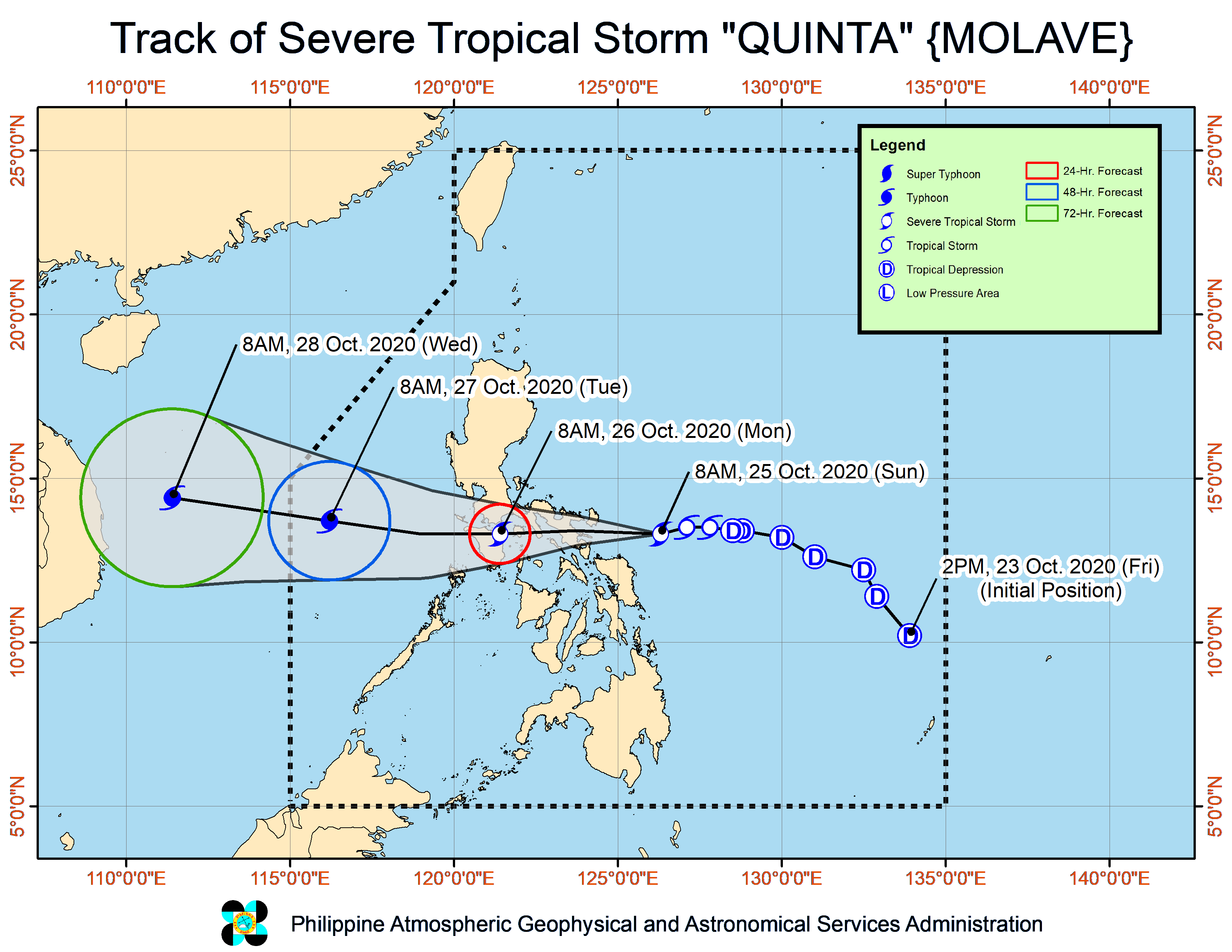
Typhoon Quinta’s track
“Quinta” was last spotted in the vicinity of Mamburao, Occidental Mindoro, with maximum sustained winds of 125 kilometers per hour and gustiness of up to 180 kph.
It is moving west at 25 kph.
Pagasa said “Quinta” is forecast to remain a typhoon but may re-intensify over the West Philippine Sea.
It is forecast to exit the Philippine area of responsibility on Tuesday morning.
The weather bureau said the typhoon will bring moderate to heavy with at times intense rains over Occidental Mindoro, Oriental Mindoro, Romblon, Marinduque, northern Palawan including Calamian and Cuyo Islands, Calabarzon, Aurora, Isabela, Aklan, Capiz, and Antique.
Moderate to heavy rains will likewise prevail over Cagayan, Apayao, Kalinga, Abra, Ilocos Norte, and Ilocos Sur due to the tail-end of a frontal system.
The two weather systems will also bring light to moderate to at times heavy rains over Metro Manila, Zamboanga Peninsula, Bangsamoro, Northern Mindanao, Caraga region and the rest of Luzon and Visayas.
Pagasa warned that flooding (including flash floods) and rain-induced landslides may occur during heavy or prolonged rainfall.
Due to the northeasterly surge, the Ilocos region, Batanes, Cagayan, Apayao, and northern Zambales will experience strong breeze to gale conditions, Pagasa said.
Storm surge warning
The weather bureau warned of a possible storm surge of up to three meters over the coastal areas of Camarines Norte, and the northern coastal areas of Quezon including Polillo Islands and Camarines Sur.
A storm surge of up to 2 meters may also be experienced over the coastal areas of Batangas, Marinduque, Occidental Mindoro, Oriental Mindoro, Romblon, and the remaining coastal areas of Quezon and Camarines Sur.
Rough seas
Pagasa said rough to high seas will be experienced over the seaboards of areas under TCWS.
The remaining seaboards of Luzon and the western, northern, and eastern seaboards of Visayas will likewise have rough to very rough seas.
“Sea travel is risky for all types of sea vessels over these waters,” the weather bureau said.
Moderate to rough seas, Pagasa said, will be experienced over the other seaboards of the country.
“Mariners of small seacrafts are advised to take precautionary measures when venturing out to sea. Inexperienced mariners should avoid navigating in these conditions,” it added.