Slower ‘Pepito‘ may exit PAR on Thursday afternoon
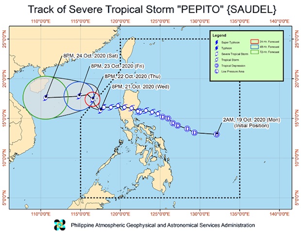
Image from PAGASA
MANILA, Philippines — Severe Tropical Storm Pepito slightly slowed down as it maintained its strength, which means that it may leave the Philippine area of responsibility (PAR) between morning and afternoon of Thursday.
Pepito was last located 305 kilometers west of Dagupan City in Pangasinan and was moving southwest at 10 kph, according to the Wednesday night severe weather bulletin of the Philippine Atmospheric, Geophysical and Astronomical Services Administration (Pagasa).
It was still packing maximum sustained winds of 95 kph, with gustiness reaching up to 115 kph.
Pagasa predicted that Pepito might make a northwest turn on Thursday morning.
It will then intensify on leaving PAR and may even become a typhoon before hitting either the southern portion of China or central Vietnam.
Article continues after this advertisementDespite moving away from the landmass of Luzon, Pepito may still bring light to moderate and at times heavy rains over Batanes, Babuyan Islands, Pangasinan, Zambales, Bataan, northern Aurora, Occidental Mindoro, Palawan, Western Visayas, Zamboanga Peninsula, and the Sulu Archipelago.
Article continues after this advertisementA gale warning remains raised over the entire seaboards of Northern and Central Luzon, the eastern seaboard of northern Quezon including Polillo Islands, and the western seaboards of Batangas, Occidental Mindoro (including Lubang Island), and Palawan (including Calamian and Kalayaan Islands).
Fisherfolk and seafarers using small boats are not allowed to set sail in those areas due to rough to very rough seas with waves possibly reaching between 2.8 meters to 5.5 meters.
Meanwhile, a low pressure area (LPA) being monitored by Pagasa moved closer at 1,780 km east of Mindanao.
The LPA might enter PAR by Friday and develop into a tropical depression over the weekend.
[atm]