


MANILA, Philippines — Tropical Depression Ofel maintained its strength as it continues to move closer to the Eastern Samar-Northern Samar area on Tuesday night, the state weather bureau reported.
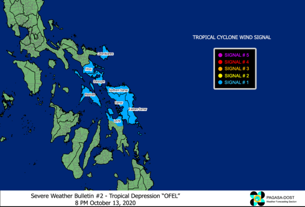
In its 8 p.m. severe weather bulletin, the Philippine Atmospheric, Geophysical, and Astronomical Services Administration (Pagasa) included more areas under Tropical Cyclone Wind Signal (TCWS) No. 1. These are:
- Catanduanes
- Albay
- Sorsogon
- Masbate including Ticao and Burias Islands
- Northern Samar
- Eastern Samar
- Samar
- Biliran
- the northern portion of Leyte (Tabango, Leyte, San Isidro, Calubian, Capoocan, Carigara, Jaro, Pastrana, Dagami, Tabontabon, Tanauan, Palo, Santa Fe, Alangalang, Tacloban City, Babatngon, San Miguel, Barugo, Tunga)
Residents in these areas are likely to experience winds of 30 to 60 kilometers per hour (kph) or intermittent rains within 36 hours, according to Pagasa.
Pagasa also said TCWS No. 1 may also be raised over Camarines Sur, Romblon, and the southern portion of Quezon in the next bulletin, which will be issued at 11 p.m. Tuesday.
Moderate to rough seas will likewise be experienced over the seaboards of Luzon and Eastern Visayas, it added.
Thus, small seacrafts were advised to take precautionary measures while venturing out to sea.
At 7:00 p.m. Tuesday, Ofel was spotted some 95 kilometers East of Guiuan, Eastern Samar with maximum sustained winds of 45 kph near the center and gustiness of up to 55 kph. It is moving westward slowly.
Ofel will make landfall over Eastern Samar-Northern Samar area on Wednesday morning, then over Sorsogon by Wednesday afternoon, Pagasa noted.