Hot, humid weather in PH to persist; storm outside PAR won’t affect climate
MANILA, Philippines — The hot and humid weather in many parts of the country will continue while the tropical storm spotted east of Luzon would not have any impact on the country’s climate.
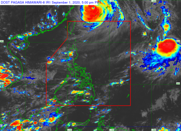
This was according to the state weather bureau’s forecast released on Tuesday afternoon, which showed the still-unnamed weather disturbance outside of the Philippine area of responsibility (PAR).
The Philippine Atmospheric, Geophysical, and Astronomical Services Administration (Pagasa) said the tropical storm was last spotted 2,355 kilometers east of extreme northern Luzon, packing maximum sustained winds of 65 kilometers per hour (kph) and gustiness of up to 80 kph.
While it is moving in a south-southwest pattern at a speed of 10kph, Pagasa does not see it making an impact as it will only graze a part of the PAR in case it enters the region.
Pagasa’s prediction for September is that two to three tropical cyclones will enter the PAR.
Article continues after this advertisement“Base po sa ating pag-aanalisa, ito po ay mababa ang tsansa na pumasok sa ating area of responsibility sapagkat bagamat ito ay kumikilos patimog kanluran, eventually ito po ay liliko patungong hilagang kanluran,” weather specialist Ariel Rojas said.
Article continues after this advertisement(Based on our analysis, the storm has a low chance of entering our area of responsibility because even if it moves in a southwestern pattern, it would eventually turn towards the northwest.)
“And in the event na pumasok ito sa ating area of responsibility, dadaplis lamang po ‘yan sa northeastern corner ng PAR, malayo po sa ating kalupaan at wala pong magiging direktang epekto sa ating panahon,” he added.
(And in the event that it enters our area of responsibility, it would only graze the northeastern corner of the PAR, far from the country’s landmass which means it would not have a direct effect on the weather.)
However, despite the humid weather, Pagasa said isolated rain showers are still possible especially by Wednesday afternoon and night. Temperatures in Metro Manila will also range from 25 to 32 degrees Celsius while Legazpi and Puerto Princesa will have 26 to 32 degrees Celsius, and Laoag, 25 to 31 degrees Celsius.
Iloilo will experience temperatures from 26 to 32 degrees Celsius while it may vary between 26 and 33 degrees Celsius in Cebu and Tacloban. For Mindanao cities, warmer temperatures may also be expected, as Pagasa said Davao and Zamboanga will feel 25 to 34 degrees Celsius-climate.
Meanwhile, gale warning is still up over the seas of Batanes since sea conditions may remain moderate to rough on Wednesday due to Typhoon Maysak, formerly known as Julian, which just left the PAR on Monday night.
As of the latest Pagasa weather bulletin, Maysak has maximum sustained winds of 175 kph and gustiness of up to 215 kph, with satellite imagery showing cloud bands on its tail reaching the extreme Northern Luzon area.
On the other hand, the rest of the country’s coastlines will have a slight to moderate sea situation.